Leigh Woods National Nature Reserve, Stokeleigh Camp and the Avon Gorge
Through the lush woodland of a nature reserve on the edge of a dramatic gorge
Google Maps Open Source Maps| Statistics and Files | ||
|---|---|---|
| Start: Leigh Woods | Distance: 3.2 miles (5.2 km) | Climbing: 178 metres |
| Grid Ref: ST 55517 73013 | Time: 2 hours | Rating: Easy |
| GPX Route File | Google Earth File | About the Avon Gorge |
| Statistics | |
|---|---|
| Start: Leigh Woods | Distance: 3.2 miles (5.2 km) |
| Climbing: 178 metres | Grid Ref: ST 55517 73013 |
| Time: 2 hours | Rating: Easy |
| GPX Route File | Google Earth File |
Ordnance Survey Explorer Map (1:25,000)
The Walk: This is a walk through the Leigh Woods National Nature Reserve and along the banks of the River Avon, set in a dramatic limestone gorge. It plunges straight into the broad leaved woodland where oak is the dominant species, but where ash, birch, lime, beech and sycamore are also found. The woodland is so all enveloping that it is difficult to believe that the heart of the city of Bristol is nearby.
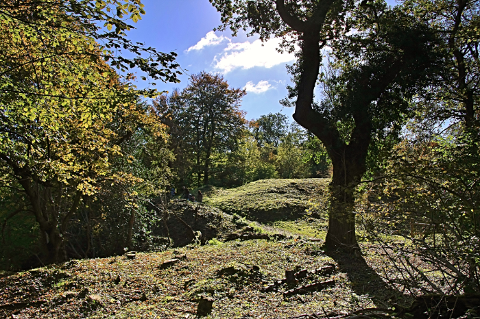 Stokeleigh Camp in Leigh Woods
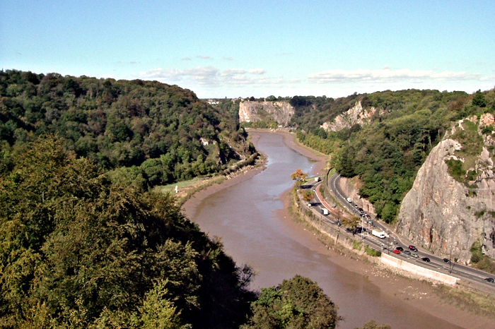 Leigh Woods, Avon Gorge and Portway
A short walk from the starting point leads to a clearing and the warden's cottage. Beyond here lies the massive ramparts of Stokeleigh Camp. This is an iron age fort built in the third century BC and occupied for about 200 years. The steep bank of the Avon gorge provides ample protection against attack from one side and the landward side is protected by a horseshoe of ditches and ramparts, the innermost one being the most impressive, rising to a height of 30 feet (9 metres). The path cuts through the middle of the fort and turns towards the rim of the gorge to arrive at a splendid viewpoint above the River Avon. To the right is the famous Clifton Suspension Bridge, designed by Isambard Kingdom Brunel. The opposite bank of the river is notable for a great series of limestone cliffs, above which can be seen the round tower of a camera obscura building. Here you stand in a dark room and watch a moving image of the world outside.
The walk continues around the rim of the gorge, where the woods thin out slightly and there are more views of the buildings of Clifton across the river. The route then goes downhill on a narrow path, which is very steep in places, leading the the riverside path, the River Avon Trail. This runs alongside the Avon for over 27 miles from Pill near the Bristol Channel to the Dundas Aqueduct on the Kennet and Avon Canal. Looking back one can see the warehouses clustered around the entrance to Bristol Docks.
An arch to the left of the walk carries the railway line to Portishead, now virtually disused. Those who wonder how they crossed the line without noticing it can be assured it was not an oversight: the path goes over the top of a short tunnel. The path turns uphill and back into the woods, where the railway crosses the deep valley of a high arched bridge. This is an altogether denser section of woodland, with a mixture of broad leaved trees and conifers. There is a good deal of wildlife: birds and squirrels are common, and badger setts can be seen. At Oakwood Lodge, the path takes to the broad driveway before turning back to run close to the fields of a local farm for the return to the start.
Acknowledgment: Text derived from the Out and Out Series; Discovering the Countryside on Foot. Pictures courtesy of Wikipedia.


