Minions, the Hurlers, Stowe's Hill and the Cheesewring
Across open moorland to see ancient sites and stones
Google Maps Open Source Maps| Statistics and Files | ||
|---|---|---|
| Start: Minions | Distance: 3.4 miles (5.4 km) | Climbing: 142 metres |
| Grid Ref: SX 26076 71160 | Time: 2 hours | Rating: Moderate |
| GPX Route File | Google Earth File | About Minions |
| Statistics | |
|---|---|
| Start: Minions | Distance: 3.4 miles (5.4 km) |
| Climbing: 142 metres | Grid Ref: SX 26076 71160 |
| Time: 2 hours | Rating: Moderate |
| GPX Route File | Google Earth File |
Ordnance Survey Explorer Map (1:25,000)
The Walk: Bodmin Moor is the site of many mysterious stone circles and strange rock formations. As the walk crosses the open moorland, intriguing evidence of man's past involvement with the area unfolds. At first this materialises in the form of the prehistoric stone circle, the Hurlers. Later, the mining and quarrying relics of relatively recent times provide the interest. The highlight of the walk comes with the ascent to the ancient hillfort of Stowe's Hill. Here you can see the famous Cheesewring and enjoy a stunning view across the Moor.
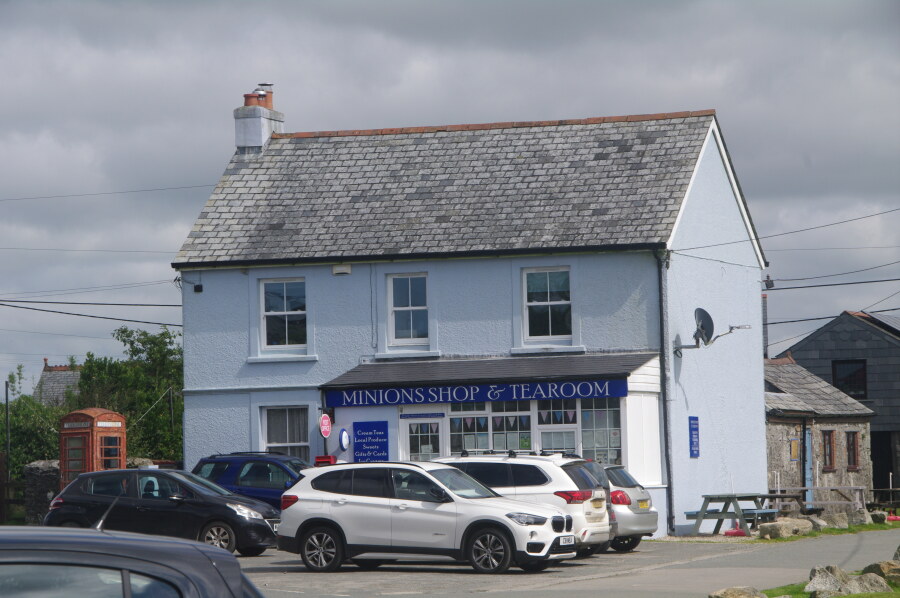 Minions Tearoom
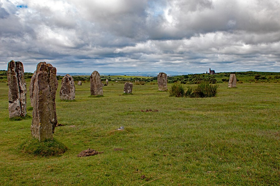 The Hurlers Stone Circle
Minions, on the south-east fringe of Bodmin Moor, was built as a mining township when the nearby Phoenix United Mine blossomed between 1842 and 1898. In its heyday around 500 people worked directly for the mining company and the mine produced an astonishing 83,000 tonnes of copper and 16,000 tonnes of tin. Minions is at an altitude of around 1,000 feet and it provides an excellent access point to the high moor.
The Hurlers comprise three stone circles, but only two stones remain standing in the southern-most circle. The standing stones are perfectly sturdy, and are designated Ancient Monument status. After visiting the Hurlers, the path leads on northwards across open moorland, directly towards Stowe's Hill.
Before the fenced edge of the granite quarry is reached, a mound can be seen over to the right. This is Rillaton Barrow and in a stone cist, or tomb, on its eastern end, the Rillaton Cup was found. This was made from solid gold and dated from circa 1500 BC. It now rests in the British Museum. Before reaching Stowe's Hill, you pass a mineshaft guarded by a rickety fence. Keep well clear of it for your own safety.
If you make a detour right, to the ground above the southwest corner of the quarry, you will find the curious Daniel Gumb's Cave. This mystic and 'mountain philosopher' who died in 1776, long before quarrying activities started, built a home for himself and his sizable family amid the natural granite blocks. The original cave was beneath a 30 foot long granite slab, but what you see now is a reconstruction built around 1870, when the quarry was extended. Gumb was an eccentric stone cutter who taught himself mathematics. And plainly visible in the roof stone is his carving of Pythagoras's Theorem. Nearby is a section of a doorpost with 'D Gumb 1735' carved into it.
An ascent of 100 feet takes you up Stowe's Hill to the Cheesewring. This weird, inversely tapered granite pillar, 25 feet in height and made up of stone rings, one on top of the other, seems to defy the natural laws of gravity. It was once thought to have a supernatural origin, and was reputedly worshipped by the ancient Druids. In fact, it is a natural formation resulting from the erosion of the softer surrounding rocks. The name Cheesewring comes from its similarity to a cider press where a large weight squeezes the juice from the 'cheese' or pulped apples.
During quarrying operations precaution was taken to protect the Cheesewring from toppling when blasting. A stone support was built to underpin the main stem. But if you look carefully, you will see the support does not actually touch the rock. In fact, such has been the importance of the Cheesewring that in 1864 an agreement between the Duchy of Cornwall and the quarry masters defined the limits of granite extraction, beyond which it was forbidden to quarry. This line was marked by a fleur-de-lis skilfully carved in the rock and this mark can still be seen today right on the edge of the quarry behind the Cheesewring. It is not necessary for you to go beyond the boundary fence to see it.
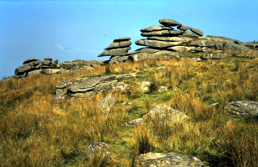 Approaching the Cheesewring
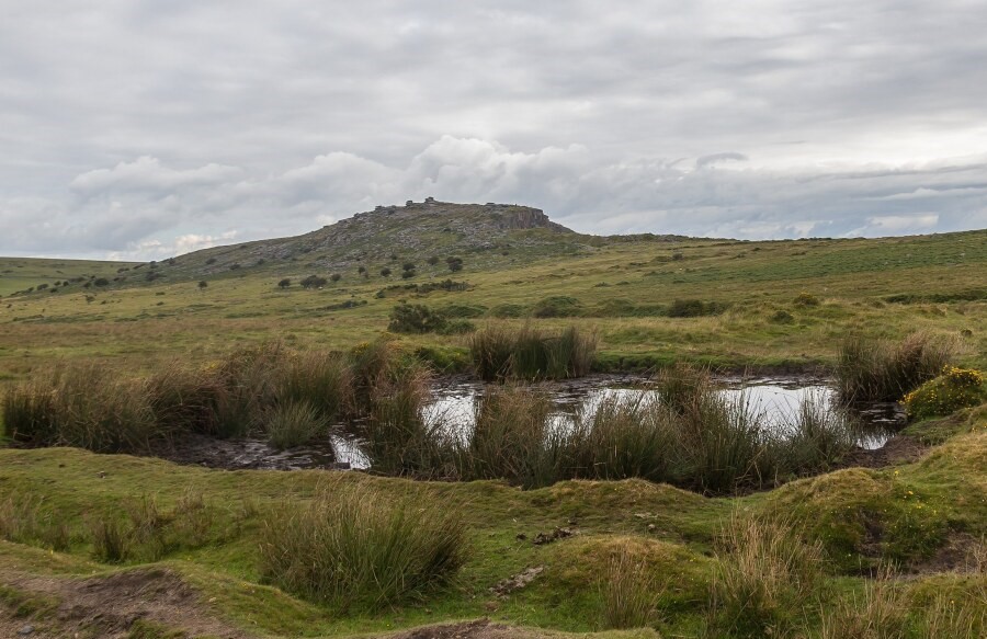 Stowe's Hill
Progressing from the giant Cheesewring to the summit of Stowe's Hill, at 1,249 feet high, you scramble over the remains of a rubble stone wall which formed 'Stowe's Pound', the ruined defences of an ancient hillfort thought to date from the Bronze Age. There are two circular wall defences on the top of the hill, the first smaller one surrounded the actual summit and the adjoining larger circle protected the rest of the hill. The fine views over the lonely surrounding moors are exceptional and on a clear day it is possible to see as far as Exmoor almost 50 miles away to the north-east. You can see past the radio mast of Caradon Hill to High Willhays on Dartmoor, and to the south Plymouth can be seen.
Before descending the east flank of the hill, skirting the fenced area of the quarry, first walk north along the flat crest of the hill. There are many more fascinating rock formations and markings to be found, and the northern extremity of the hill overlooks Witheybrook Marsh and ancient field systems.
The quarry is now derelict, but at its peak in the late 1860's it employed over 100 men and boys. The beautiful silvery grey granite was sought for its fine architectural qualities. Delivered to Looe by rail, it was then shipped to London and overseas. Westminster Bridge, Tower Bridge and the Thames Embankment in London are all made from this striking Cornish granite. From here, the quarry track, formerly the railway, leads easily back to Minions.
The two birds of prey most likely to be seen here are the Kestrel and the Merlin. On the ground, Rabbits are common, and with luck you may see a Weasel running like lightning across the track. At dusk, which is the most atmospheric time to visit the Hurlers, look out for the elusive Red Fox. And in the darkening sky at twilight, the tiny Pippistrell Bat can sometimes be seen.
Acknowledgments: Text derived from the Out and Out Series; Discovering the Countryside on Foot. Pictures courtesy of Wikipedia.


