Ebbor Gorge, Fair Lady Well, North Hill and Priddy
A varied walk through a deep wooded gorge to the mysterious sites of Neolithic Man
Google Maps Open Source Maps| Statistics and Files | ||
|---|---|---|
| Start: Car Park | Distance: 7.7 miles (12.3 km) | Climbing: 283 metres |
| Grid Ref: ST 52079 48462 | Time: 4 hours | Rating: Moderate |
| GPX Route File | Google Earth File | About Ebbor Gorge |
| Statistics | |
|---|---|
| Start: Car Park | Distance: 7.7 miles (12.3 km) |
| Climbing: 283 metres | Grid Ref: ST 52079 48462 |
| Time: 4 hours | Rating: Moderate |
| GPX Route File | Google Earth File |
Ordnance Survey Explorer Map (1:25,000)
The Walk: The walk incorporates the best of Mendip scenery, as well as sites of great historic interest. It includes a deep wooded limestone gorge, a rough upland plateau, prehistoric sites dating back for thousands of years, and the crumbling remains of the once important lead mines. The walk begins with a steep descent, eased by steps cut in the path through woodland to the foot of Ebbor Gorge. The valley, carved out by an ancient river, is marked by high limestone cliffs that rear up on both sides of the footpath. The many small caves and rock shelters were once home to animals such as wolves and bears, long since extinct in Britain. and were used by Neolithic man as long ago as 3000 BC. Today, the gorge offers a splendid walkway hemmed in by trees and overhanging limestone crags that gradually close in to form a narrow passage through the rocks. The way out at the far end of the gorge is a rock path through a narrow defile where the crags seem almost to close in overhead.
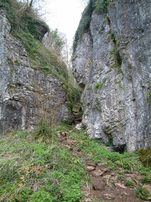 Approaching Ebbor Gorge
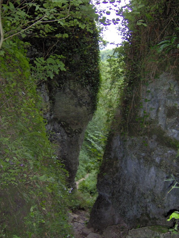 A squeeze in Ebbor Gorge
Having climbed out of the gorge, the path leads on to the edge of the woodland and out on to an area of rough grassland dotted with gorse bushes. From the top of the hill there are magnificent views out across the flat plain to the Somerset Levels, interrupted by the shapely cone of Glastonbury Tor. An area of disturbed ground near the top of the hill is evidence of former mining activity. Beyond Higher Pitts Farm the walk continues beside the limestone walls, which are a characteristic feature of the area. Here on the plateau, the meadows are rich and lush with a mixture of grasses and clover.
The route briefly joins the main road before turning off along a footpath with an area of rough, disturbed ground. To the right is the site of the old St Cuthbert's Lead Works. Lead was mined in the Mendips as long ago as Roman times, but the works were abandoned as the ores ran out. Then in the 19th century, a new technology was introduced that enabled substantial quantities of the metal to be recovered from the previously unproductive spoil heaps.
The remains of these works, which only closed in 1908, can be seen on the other side of the little valley. Furnaces were set up and the waste gases were fed down a series of flues, in which the lead condensed. To recover it, workers had to crawl the length of the flues, scraping the lead deposits off the walls. It was a dangerously unhealthy occupation. Remains of flue systems and surface buildings can still be seen, together with heaps of slag from the furnaces.
The walk itself, past the mining site, runs through pine trees, heather and gorse to a small pond called Fair Lady Well. The well has perhaps a prehistoric origin, being close to the disused lead mines and other prehistoric remains. It is mentioned in as a boundary mark in the 13th Century, and appears to have become Fair Lady Well some time later. There appears to be some old stone work surrounding the spoon shaped well, reinforcing its importance in olden times.
The path now heads uphill through an area of rough tussocky grass, bracken and gorse. Lead Pollution ensures that these lower slopes remain wild, but nearer the top of the hill, the fields can be grazed so this area is springy, close-cropped turf. Here is a spectacular Bronze Age barrow cemetery.
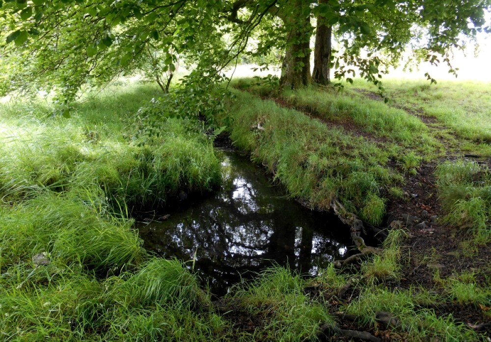 Fair Lady Well
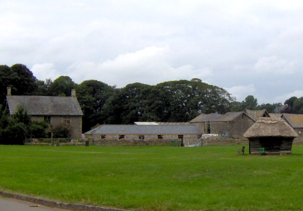 The village of Priddy
The people who lived in this area in a period from roughly 2000 - 500 BC are best known for their practise of burying their dead under great circular mounds, or barrows. There is a magnificent set here, some of which are simple mounds, while others are more elaborate. The path passes through the barrows, and beyond the roadway, affords a glimpse of an even older prehistoric site. The 'Priddy Rings' are not easy to distinguish, but they can be discerned as big, dark circles in the fields. This is a Neolithic site, constructed between 4000 - 2000 BC, and is comparable to the more familiar stone circles of the ancient world. They are presumed to have religious significance, but this is uncertain.
Turning away from the prehistoric sites, the path leads back through the fields to the road down to the village of Priddy. This is a quiet country lane with high banks on either side. Priddy itself is an attractive, small community, centred on an extensive green. A sheep fair is held here every year and the hurdles are stored in a little shelter. Just outside the village, the route leaves the road for a walk across fields to the outskirts of the woodlands above Ebbor Gorge.
The final section of the walk runs through the National Nature Reserve. Where the first part of the walk kept to the bottom of the gorge, this section skirts the rim of the gorge. Having taken the steep path down to the bottom of the valley and climbed up the other side, a signpost indicates a side turning off the route to Cliff Top View. This leads out to a superb vantage point on top of the limestone crags. The way then descends again and climbs back up to the car park.
Acknowledgments: Text derived from the Out and Out Series; Discovering the Countryside on Foot. Pictures courtesy of Wikipedia.


