Haytor Vale and Haytor Rocks
Through the panoramic vistas of Dartmoor to a unique stone railway
Google Maps Open Source Maps| Statistics and Files | ||
|---|---|---|
| Start: Haytor Vale | Distance: 4.8 miles (7.8 km) | Climbing: 233 metres |
| Grid Ref: SX 76539 77163 | Time: 2 hours | Rating: Easy |
| GPX Route File | Google Earth File | About Haytor |
| Statistics | |
|---|---|
| Start: Haytor Vale | Distance: 4.8 miles (7.8 km) |
| Climbing: 233 metres | Grid Ref: SX 76539 77163 |
| Time: 2 hours | Rating: Easy |
| GPX Route File | Google Earth File |
Ordnance Survey Explorer Map (1:25,000)
The Walk: The Rock Inn in Haytor Vale was originally built in 1825 as a hostelry for workers at the nearby quarry. Today it is a popular country inn, in an attractive village on the eastern edge of Dartmoor. From the start, the walk goes gradually uphill between stone walls and hedgerows, but soon opens out to a wide expansive moorland. He it joins the route of the old Haytor Granite Tramway.
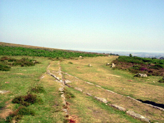 Haytor Tramway
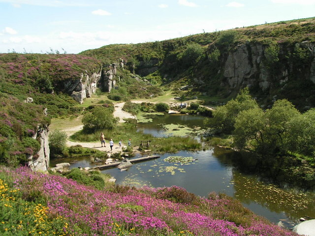 Haytor Quarry
The tramway was built in 1820 to join the quarries around the valley of the River Teign to a canal in the valley. Horses pulled wagons along the track, unique because of its stone rails. Tramways like this one were common, but most of them used iron rails. Iron, however, was an expensive commodity at the time in Devon, and there was no shortage of hard wearing granite. So this primitive railway used stone instead.
The tramway runs through a lovely section of moorland with little to break the silence, bar the sound of the wind and the call of the skylarks. Only a jumble of boulders mark the quarries that the tramway served. Stone from here ended up in some of London's best known buildings, including the National Gallery and the British Museum.
Where the tramway divides near the quarries are the 'stone points'. At the junction a hole was drilled in the rock. A metal plate was bolted here to move the trucks from one set of rails to the other.
From the tramway there are magnificent views over Dartmoor. A slope smothered in heather and gorse leads up to a spiky summit, bristling with shattered rocks. The tramway itself dips into a shallow cutting, before petering out at the edge of a quarry system. But by scrambling up the rocks to the left, you can see the remains of yet more stone rails, part of a branch line from the quarry itself.
 Approaching Haytor
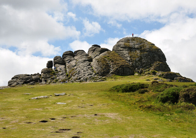 Haytor Rocks
Two massive rock outcrops make up Hay Tor itself. These tors are a distinctive feature of the moor. Some seventy five million years ago, smooth granite domes lay exposed above the softer sedimentary rocks. Then around 600,000 years ago, the area suffered the arctic conditions of the Ice Age. The alternate freezing and thawing attacked the rock, opened up cracks and producing the pattern of broken towers on the moorlands rock summits.
Hay Tor with its two separate outcrops is among the most spectacular on Dartmoor. From the tor there are splendid views to the south, right across to the South Devon coast and the sea. Beyond here the character of the walk changes once more. The crowds that flock to the tor thin out and you can enjoy a quiet walk on a track that curves right round the low hill opposite. Here you look out on the field at the edge of the moor with narrow lanes snaking away through high hedgerows.
Acknowledgments: Text derived from the Out and Out Series; Discovering the Countryside on Foot. Pictures courtesy of Wikipedia.


