Hinton Charterhouse, Midford, Combe Hay and Wellow
Explore an unusual system of disused railways and canals
Google Maps Open Source Maps| Statistics and Files | ||
|---|---|---|
| Start: Hinton Charterhouse | Distance: 9.5 miles (15.2 km) | Climbing: 403 metres |
| Grid Ref: ST 77669 58274 | Time: 4-5 hours | Rating: Moderate |
| GPX Route File | Google Earth File | Hinton Charterhouse |
| Statistics | |
|---|---|
| Start: Hinton Charterhouse | Distance: 9.5 miles (15.2 km) |
| Climbing: 403 metres | Grid Ref: ST 77669 58274 |
| Time: 4-5 hours | Rating: Moderate |
| GPX Route File | Google Earth File |
Ordnance Survey Explorer Map (1:25,000)
The Walk: Despite the industrial nature of this walk, it begins in the village of Hinton Charterhouse and immediately leads to a magnificent stately home and a medieval priory. Hinton House was built in 17O1. It presents a handsomely classical frontage to the world with pedimented windows and a porch with Ionic columns, the whole effect completed by the balustrade that runs along the walls. The park is grassland dotted with mature trees.
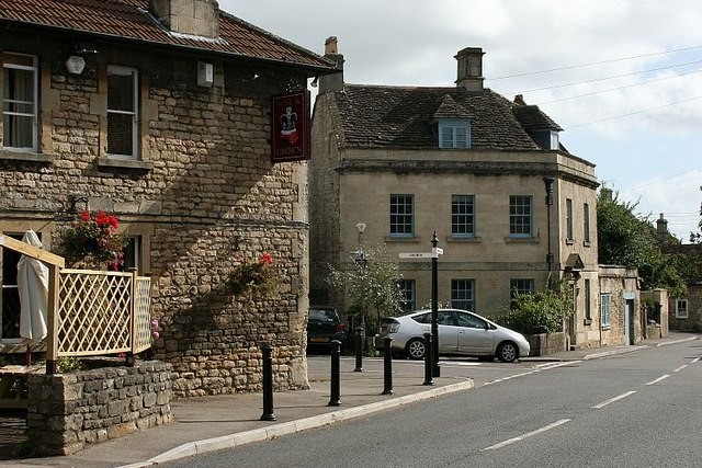 Hinton Charterhouse
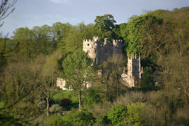 Midford Castle
Across the road are the remains of Hinton Priory. This was the Charter house that gave the village its name. Founded in 1232, the same year as Lacock Abbey, it is one of the oldest Carthusian houses in England. The main building is a tower with a gable roof and is built in a simple style with buttresses and lancet windows.
This was the chapter house where priory meetings were held and there was a library on the top floor. There are also remains of the refractory and excavation has shown that there was originally a cloister, around which were grouped 14 small houses or cells.
During Henry VIII's dissolution of the monasteries, the old Gate House was incorporated into a new dwelling. The splendid house that you can see today received its last major alterations late in the 16th century.
The walk continues across grassy fields to the small settlement of Pipehouse. After that, you join a track that begins as a broad avenue flanked by oak trees, but gradually closes in until it becomes a very steep gully running between high banks. The building to the right, looking like an overgrown Olympic torch, is a water tower. At the higher points of the hill there are views over to the right of the 18th century house Midford Castle, while down in the valley on the left is a curious building with a pyramidal roof. This is a malt house. The roof covers the kiln where barley is heated. At the end of the path is the village of Midford with an old water mill beside the stream. The scene up ahead is dominated by what looks like one big railway viaduct.
When you reach it, you discover there is not one viaduct, but two. The second threads its way under the arches of the first. The road itself crosses the brook on an old stone bridge. After the Hope and Anchor pub up on the main road, a footpath now runs down to the towpath of the derelict Somerset Coal Canal.
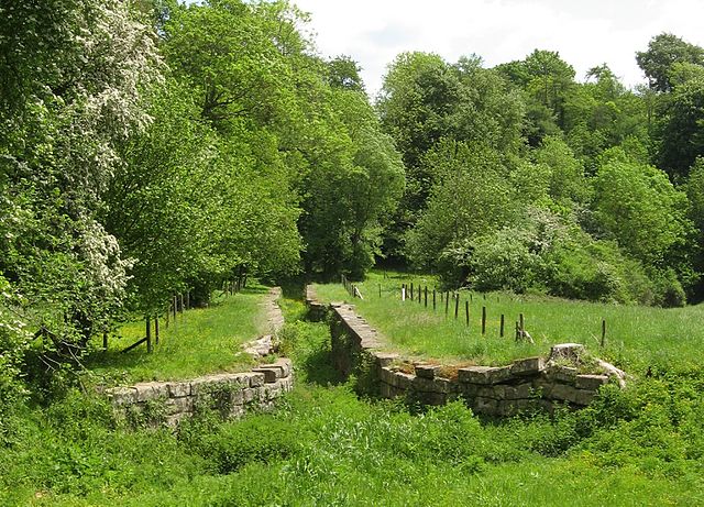 Coombe Hay Locks, Somerset Coal Canal
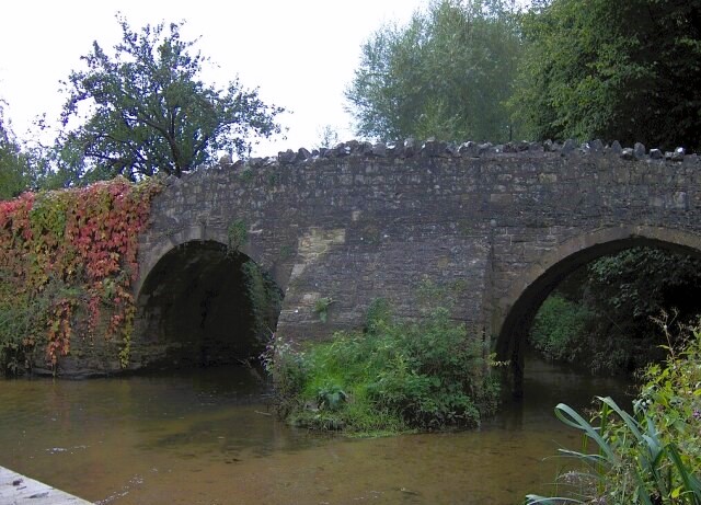 Wellow Bridge
The canal runs along the bottom of the valley, mimicking the winding path of the Cam Brook. This is a particularly attractive section of the walk, with green fields on the valley floor and oak woodland rising up the bank beyond the canal. On the left, you can see what appears to be a ruined stone bridge over the brook. This is an aqueduct that carried a branch of the canal down to Radstock. As you climb up the valley, the canal begins to climb through a series of locks. At first, well spaced, then coming closer together. The canal swings away through woodland, dominated by massive beech trees, then suddenly does a complete U-turn in Engine Wood to head up towards Coombe Hay. The footpath takes a more direct route, so it comes as a surprise after climbing the hill to find yourself back beside the canal again.
Coombe Hay is an attractive village of mellow stone houses. Old Rectory enjoys a fine position with wide views over the surrounding rolling countryside. Beyond the church, you leave the road for a path past the 18th century Coombe Hay Manor. In the grounds you can see an obelisk and in the distance, a little rotunda beside an ornamental lake. The path climbs up the hill on the opposite side of Cam Brook with yet more splendid views out over a wide stretch of country all the way to the outskirts of Bath.
The footpath gives way to roadway. But this is a quiet country lane running between high edges. The views are still magnificent and you can see other similar lanes bordered by hedges, looking from a distance like long furry caterpillars. This section of the walk leads to the southernmost point of the walk when reaching the village of Wellow. The highlight here is the magnificent medieval packhorse bridge which spans Wellow Brook.
On leaving Wellow the roadway walking gives way again to a footpath over fields leading to the hamlet of Twinhoe. Afterwards, the way drops down to yet another peaceful valley with a gently meandering stream. Beyond the stream is an area of coppiced woodland. These are managed woods in which shoots from the stump are grown up as poles, which are then harvested and a new set of shoots begin to grow again.
A tiny tributary stream has cut a deep cleft in the hillside up which the path climbs back to Hinton Charterhouse. The village is notable for its old stone houses and makes a fitting finale to the walk.
Acknowledgments: Text derived from the Out and Out Series; Discovering the Countryside on Foot. Pictures courtesy of Wikipedia.


