Somerset Levels: Westonzoyland and Middlezoy
A walk through the flat wetlands of the Somerset Levels
Google Maps Open Source Maps| Statistics and Files | ||
|---|---|---|
| Start: Westonzoyland | Distance: 6.8 miles (11.0 km) | Climbing: 35 metres |
| Grid Ref: ST 35187 34770 | Time: 3 hours | Rating: Easy |
| GPX Route File | Google Earth File | Somerset Levels |
| Statistics | |
|---|---|
| Start: Westonzoyland | Distance: 6.8 miles (11.0 km) |
| Climbing: 35 metres | Grid Ref: ST 35187 34770 |
| Time: 3 hours | Rating: Easy |
| GPX Route File | Google Earth File |
Ordnance Survey Explorer Map (1:25,000)
The Walk: The walk begins at the village of Westonzoyland, close to the site of The Battle of Sedgemoor. In 1685 the Duke of Monmouth landed at Lyme Regis with a small army to claim the British throne. He advanced towards London. Collecting supporters as he went. His bid for power ended here.
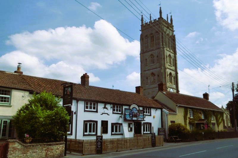 Sedgemoor Inn, Westonzoyland
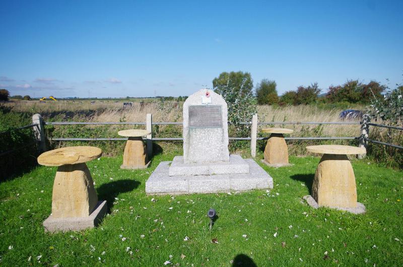 Battle of Sedgemoor Memorial
Next to Westonzoyland Church is the Sedgemoor Inn, where an elaborate painted sign above the door tells the story of the rebellion and its aftermath. Monmouth's supporters were rounded up and tried at the infamous 'Bloody Assizes', presided over by Judge Jeffreys. He executed some 150 to 200 of the rebels and had hundreds of others sold into slavery in the colonies.
Immediately after the battle, 500 of the rebels were held in the church itself. Five died of their wounds and 22 were subsequently hanged. Nothing in his beautiful church now serves as a reminder of those times, except perhaps the massive studded main door. Inside, the principal feature is the beautifully carved roof of the nave. Although the church is a Norman Foundation, most of what you see today dates from the 14th and 15th centuries.
The walk begins in the village, but soon turns off onto what was one of the main drove roads across the levels. At first the track runs between hedges and trees, then opens out into the typical wetland scenery of the region.
Left to its own devices, this area of wetland would be marshes that would regularly disappear under flood water. But the land has been steadily reclaimed since medieval times, and the most obvious features are the drainage ditches that divide up the land into a neat checkerboard of square fields. They all serve another function, acting as moats to keep the cattle that graze the meadows, so that this is a very open landscape where hedges are seldom needed.
The area may be very open, but this is a rich habitat. The ditches are lined with waving lines of reeds and sedges and flashes of colour from yellow water irises and willow. In summer the meadows are a colourful sight. The area itself is home to a large population of dragonfly and waterfowl populate the wider waterways. The geography of the area has dictated the siting of the villages and farms. Where the land rises gently to a long ridge you may see the stumpy tower of Middlezoy Church.
As you climb up the ridge, the longer grasses of the meadows give way to a short coarser grass. Trees thrive and the land is ploughed for crop growing. Dropping down the other side of the ridge brings you to the village of Middlezoy which is worth a look around before returning to the wetlands and walking alongside another system of ditches. These are in general wider than those met on the first part of the walk and the pattern of artificial channels is particularly clear as they turn at perfect right angles to form field boundaries.
From the footpath between Middlezoy and Henleys Farm, there is a clear view across to the shapely Hill of Burrow Mump topped by a ruined church. It is a prominent landmark and a site of historical interest. In 878 the Danes overwhelmed the English forces led by the Wessex King, Alfred the Great. Alfred retreated to the Somerset marshes and started the slow rebuilding of his forces. He used Burrow Mump as a lookout post to warn of Danish attacks until he was ready to lead his armed forces out of their retreat. By 880 he was again in control of the whole of the Kingdom of Wessex. Later the Normans came and built a castle here which was later still replaced by a church. Work was then begun on a second church, the one you can now see, in the 18th century, but unfortunately it was never completed.
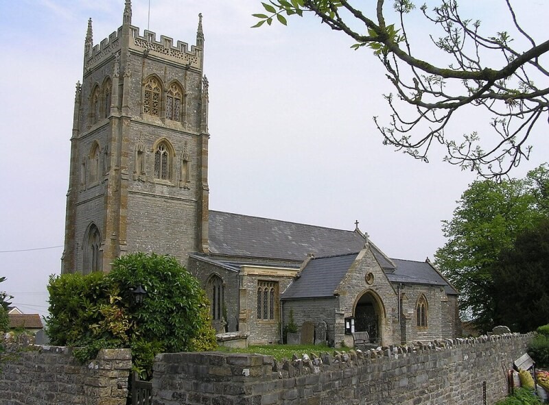 Middlezoy Church
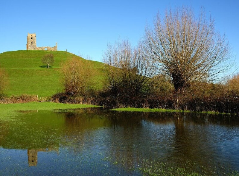 Burrow Mump
The path arrives at another patch of higher ground with a farm and orchard before joining the road that runs parallel to the River Parrett. A little way further along, it crosses a broad ditch beside which a tall brick chimney marks a prominent landmark. This belongs to Westonzoyland Pumping Station.
Keeping the levels drained of water has always been a problem. In 1830 a steam engine was brought to the task, but the first version proved inadequate and a new one was installed in 1861. This engine powered an enormous centrifugal pump that drained some 2,000 acres, lifting the water out in to the ditch so that it could eventually flow down to the River Parrett and into the sea.
Beyond the pumping station, the road turns right back towards Westonzoyland. An obvious and impressive feature is the high bank to the left of the road. Long before the arrival of the steam engine, the best means of controlling floodwaters were such high banks accompanied by draining ditches. The earliest date back to medieval times and old houses have been built on top of the banks.
This country lane also supplies willows for one of the traditional rural industries of the Somerset Levels, the growing and treating of willows for basket making. The site is marked by patches of cultivated willows and the simple sheds where they were treated. The obvious signs are the bundles of willows stacked waiting for treatment or ready to be sent on their way, and the boiler with its stubby brick chimney. The site can be found on the right hand side of the road at the point where the first of the houses appears on top of the flood bank. From here, it is only a short walk back to the village of Westonzoyland.
The walk has been over what some would regard as almost tame countryside. But the ditches, the high banks and pumping stations serve as a reminder that this is an area that was once conquered by man after centuries of struggle. Even now, flooding is by no means unknown, and the efforts to prevent it, as well as to claim yet more land for agriculture, means that it faces an uncertain future. At present, there is a balance between farmland and wetland habitats where wildlife thrive and the Somerset Levels have a unique atmosphere that many grow to love.
Acknowledgments: Text derived from the Out and Out Series; Discovering the Countryside on Foot. Pictures courtesy of Wikipedia.


