Old Sarum, Little Durnford and River Avon
A walk around an ancient fortress and along the beautiful Avon
Google Maps Open Source Maps| Statistics and Files | ||
|---|---|---|
| Start: Old Sarum | Distance: 4.7 miles (7.6 km) | Climbing: 121 metres |
| Grid Ref: SU 14031 32585 | Time: 2 hours | Rating: Easy |
| GPX Route File | Google Earth File | About Old Sarum |
| Statistics | |
|---|---|
| Start: Old Sarum | Distance: 4.7 miles (7.6 km) |
| Climbing: 121 metres | Grid Ref: SU 14031 32585 |
| Time: 2 hours | Rating: Easy |
| GPX Route File | Google Earth File |
Ordnance Survey Explorer Map (1:25,000)
The Walk: Once a fortress of the ancient Britons, the Romans called it Sorviodunum, the Saxons Searisbyng and the Normans Sarisberie. But a bitter feud between the clergy and the military at the beginning of the 13th century proved a decisive turning point in the history of this ancient place. Sited on a hilltop, the multiple earthworks covers 56 acres and impart a strong sense of vanished glory. The remains of the Norman keep are today neatly labelled by the owners, English Heritage. From the castle walls the foundations of the Norman cathedral can be seen. William the Conqueror had paid off and demobilised his victorious army here, and his nephew Bishop Osmond completed the first cathedral.
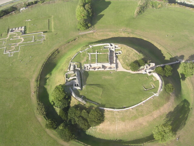 Overhead view of Old Sarum
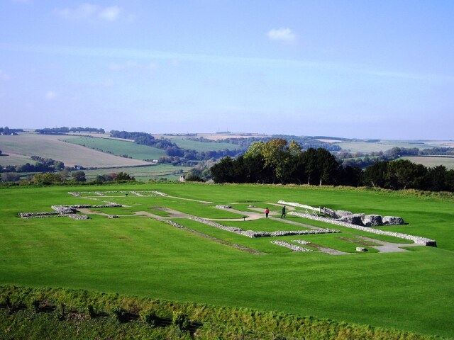 Old Sarum
In 1220, Bishop Richard Poore decided to move from Old Sarum. His clergy had been locked out of the city after returning from a procession, and this was the final straw in a long running dispute. Old Sarum already had a shortage of water and now stands deserted while its thriving successor, the city of Salisbury, flourishes below.
Old Sarum became one of the 'rotten boroughs' of the 18th century, returning two MPS from an electorate of just ten people. One of them was William Pitt the Elder.
The surrounding downs were once covered with beech woods - until ancient man began felling them. Though the downs are mostly grassland now, the beech is still the most common tree. The grasslands support a wide range of flowering plants, including white and purple violets and lords and ladies, and a wealth of insects, including many butterflies and grasshoppers. Also to be found are Wiltshire snails which were a famous local delicacy served with garlic butter.
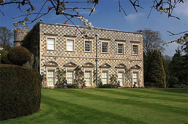 Little Durnford Manor
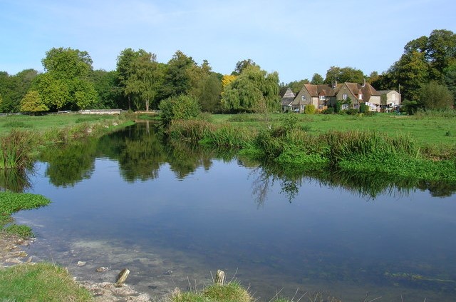 River Avon
Rain soaking through the chalk emerges as springs and creates the pure chalk streams and rivers famous in this area for trout. Swans and wagtails can also be seen by the water side.
Until recent times, March and April were difficult months for shepherds to feed their sheep. Winter hay had run out and the spring pasture was not ready. The solution was to create water meadows. These can be found in many counties, but Wiltshire has particularly fine examples. A system of trenches and drains were dug, leading off, then back to a main river. The meadows were irrigated by running water onto them.
Half way on the walk, you pass Little Durnford Manor. It is a Grade I-listed country house in Durnford, Wiltshire, England, about 3 miles (4.8 km) northeast of the city of Salisbury. The current house was built in the late 17th century and remodelled for Edward Younge, a friend of Lord Pembroke, around 1720–1740.
Back at the start of the walk, near Old Sarum, there are magnificent views looking south over the city of Salisbury. While you look think about the hustle and bustle going on down in the metropolis and imagine that this type of frenetic activity once took place within the confines of Old Sarum.
Acknowledgments: Text derived from the Out and Out Series; Discovering the Countryside on Foot. Pictures courtesy of Wikipedia.


