Portesham, Black Down, Bronkham Hill and Corton Hill
Across the Dorset Downs overlooking the English Channel
Google Maps Open Source Maps| Statistics and Files | ||
|---|---|---|
| Start: Portesham | Distance: 6.7 miles (10.7 km) | Climbing: 344 metres |
| Grid Ref: SY 60240 85761 | Time: 3 hours | Rating: Moderate |
| GPX Route File | Google Earth File | About Portesham |
| Statistics | |
|---|---|
| Start: Portesham | Distance: 6.7 miles (10.7 km) |
| Climbing: 344 metres | Grid Ref: SY 60240 85761 |
| Time: 3 hours | Rating: Moderate |
| GPX Route File | Google Earth File |
Ordnance Survey Explorer Map (1:25,000)
The Walk: A magnificent viewpoint over the western approaches to the English Channel from Black Down is the outstanding feature of this walk. The route also includes two long ridge walks along some of the highest of Dorset's seaward downlands, with more splendid views. It starts from Portesham village, the boyhood home of Sir Thomas Masterman Hardy, captain of Nelson's flagship HMS Victory, who eventually became a vice-admiral. The route climbs to a monument erected in his memory. Much of the walk is through an area of Special Scientific Interest, particularly rich in plant and bird life. Evidence of early man dating from Neolithic times can be seen on the hillsides.
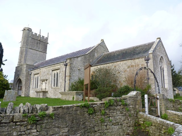 Portesham Church
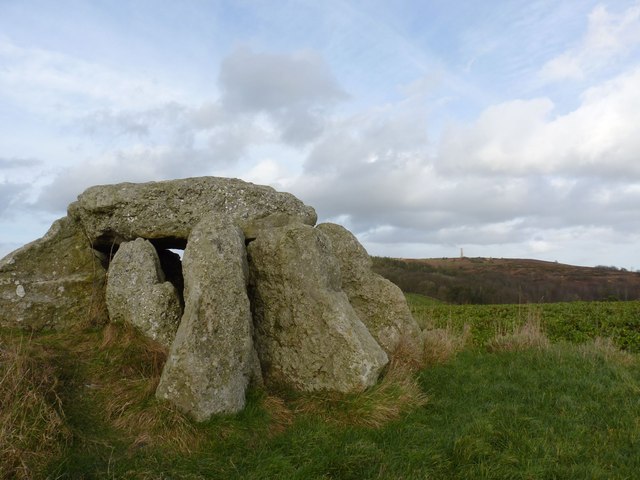 Hell Stone Burial Chamber
Portesham is a pleasant village tucked in a hollow among the steep Dorset Downs, with a clear stream overhung with ferns running beside its main street. Most of the houses are built of local stone. There is no view of the sea from here, but in a south-westerly gale you can hear the roar of The breakers on Chesil Beach, just three miles to the South.
The church has many interesting features, including the Norman font, a beautiful 15th century screen, and a Jacobian pulpit. During the Civil War, fierce fighting took place in this area, and several musket balls have been removed from the south door, which dates from the 15th century, and retains its original lock and key. Portesham House was Thomas Masterman Hardy's boyhood home. It is a simple, two storey stone built house with a stone slab roof.
Dating back to Neolithic times, to about 3,000 BC, the Hell Stone is a chambered long barrow, or burial chamber. The nine upright stones supporting a large single flat rock were restored in 1866, possibly incorrectly, but there are traces of a barrow mound at least 88 feet long and 40 feet wide, with a maximum height of five feet associated with the stones. Frederick Treves, a Dorset historian, writes that the door opens towards the sea and the sun at its height, and that for many years, the tomb was a welcome shelter for shepherds.
The woods with their pollarded oaks, beech and hazels, together with the downloads above, have been designated a site of Special Scientific Interest. Beneath the trees, many kinds of wild flowers flourish. The bluebells form a brilliant scented carpet in May. Roe Deer can be seen among the trees. The Downs formed the western extremity of the acid Bagshot beds and are studded with heathland plants, including ling and bell heather, wavy hairgrass, bristle bent, wood surge, broad buckler ferns, mosses and lichens. Butterflies include the silver studded blue and the green hairstreak. Apart from birds of prey, buzzards and hawks, stonechats scolding from the top of gorse bushes, goldcrests and linnets may be seen.
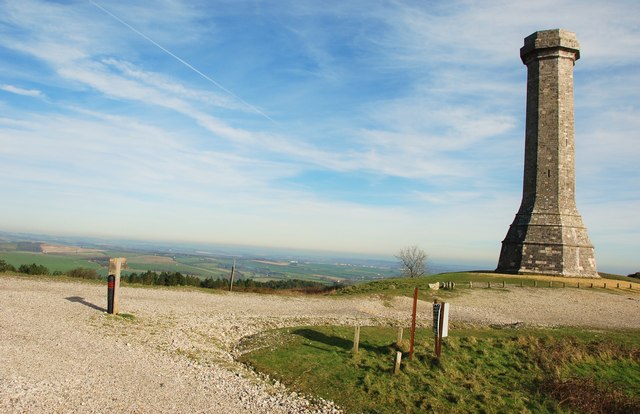 Hardy Monument on Black Down
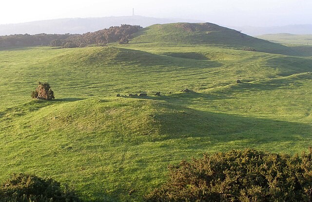 Tumuli on Bronkham Hill
The monument to Admiral Hardy has been compared to a factory chimney or a telephone receiver placed on end. A plaque reveals that it was erected by public subscription in 1844. However, there are wide views from this hilltop over the English Channel, and it seems appropriate that a great sailor should be remembered here. The novelist Thomas Hardy, who claimed the Admiral as an ancestor, could see the memorial from his bedroom window in the cottage where he was born at higher Bockhampton. He featured the Admiral in his only historical novel, The Trumpet Major.
Black Down is one of the original Beacon Hills that were used across the country as an early warning system. A great fire was lit here in 1588 to herald the approach of the Spanish Armada. during the threat of invasion by Napoleon, the Beacon keepers lived in a small hut beside their beacon, waiting to light it should danger threaten. A modern beacon was placed here in 1988.
The view from Black Down, over 700 feet above sea level, is spectacular. It commands the whole of the western approaches from Start Point in the west to Weymouth in the east. Long waves of rolling Downs stretch on either side. The route which follows one of these, Bronkham Hill, reveals more splendid views, with here and there a glimpse of The Fleet, the narrow inlet sea trapped behind the Chesil Bank.
Bronze and Iron Age men buried their dead in great numbers along the length of Bronkham Hill. The seaward ridge may have been of special significance to them. Towards the end of the walk, there are remnants of a Tudor Manor set among gardens.
Acknowledgments: Text derived from the Out and Out Series; Discovering the Countryside on Foot. Pictures courtesy of Wikipedia.


