Lundy Island
An exploration of the wildlife haven that is Lundy Island
Google Maps Open Source Maps| Statistics and Files | ||
|---|---|---|
| Start: Lundy Jetty | Distance: 7.7 miles (12.4 km) | Climbing: 405 metres |
| Grid Ref: SS 14519 43704 | Time: 3-4 hours | Rating: Moderate |
| GPX Route File | Google Earth File | About Lundy |
| Statistics | |
|---|---|
| Start: Lundy Jetty | Distance: 7.7 miles (12.4 km) |
| Climbing: 405 metres | Grid Ref: SS 14519 43704 |
| Time: 3-4 hours | Rating: Moderate |
| GPX Route File | Google Earth File |
Ordnance Survey Explorer Map (1:25,000)
The Walk: The BBC's national shipping forecast may have made Lundy a household name, but few will know anything else about this remarkable island. Viewed from Pembroke or from the North Devon coast, the island appears to float in the Bristol Channel like a huge whale. On closer inspection, it is found to be a granite mass three miles long and half a mile wide, which rises precipitously 400 feet from the surrounding and exceptionally clear sea. Topped by green fields it now sports a small working community and is famous for its bird life and flora. It also holds many relics bearing testimony to its rich and colourful history.
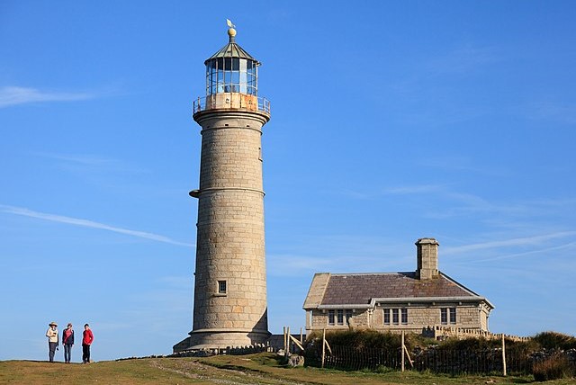 Lundy Old Lighthouse
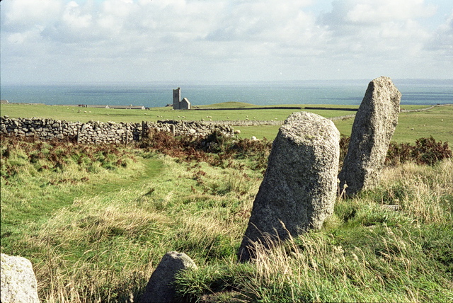 Beacon Hill, Lundy
The trip on the MS Oldenburg is an adventure in itself. Landing is like taking a pleasure step back in time. There are no cars on the island, and the Landmark Trust restoration charity that administers Lundy on behalf of the National Trust has done a remarkable job in preserving a small working community whose granite buildings comprise a small village, church and farm. There are fine views to the North Devon Coast some 11 miles distant while to the west 4,000 miles of ocean separate Lundy from land. Space and tranquility pervade the place. All of these elements, combined with the outstanding natural history of the island, make for a fascinating walk.
Leaving the disembarkation point, the stony track passes a cave and battered cannon. The cannon is thought to have been thrown down from above by a party of French privateers during the reign of William III. Further up, on either side, can be seen a species of plant endemic to the island, the Lundy cabbage. This has long straggly stalks, which bear small yellow flowers from mid June to mid August.
Visitors are welcome to enter St Helena's Church but are requested to close the door behind them to keep out the sheep. The church was built in 1896 by the Reverend Hudson Heaven, who then owned the island, and it became known as 'the Kingdom of Heaven'.
The castle dates from 1244 and was built by Henry III in an attempt to control the island following a century of rule by the notorious de Marisco family. During the reign of King John (1167-1216), William de Marisco used the island as a base for his piratical activities.
Further along the route is a view of Benjamin's Chair, a grassy platform named after a ship that was wrecked in the bay below. Shortly after this, you may spot a mound, the remains of an ancient burial chamber called Kistvaen, rising from the bracken and gorse. Rocket Paul Pond appears beyond Rocket Paul, where practice rockets carrying life lines used to be fired. A few breadcrumbs thrown into the pond result in frenzied feeding by the mirror carp lurking within its depths. In summer, large patches of basil and thyme may be seen around here. Look out for yarrow, with its white flowers and fern like leaves.
The next feature on the walk is the great rift hole of the Devil's Limekiln, the steep granite walls of which plunge 300 feet. Following this, there is a fine view of the western coast and a bay where Lundy's most famous wreck occurred; that of the battleship HMS Montagu, which foundered here in May 1906 during thick fog.
The cemetery reveals some of the islands past and was the site of the original St Elans Chapel; the foundations can still be seen close to the wall of the lighthouse compound. Four ancient memorial stones inscribed in Latin now stand against the west wall, attributable to the Christian community that survived here after the collapse of Roman rule in Britain.
The Old Light was completed in 1819 by Trinity House at a height of 567 feet above sea level. It was the highest in Britain, alas too high, for it was often in cloud when all was clear at sea level. Hence the construction of Lundy's other two working lighthouses (the North and South Lights). The Battery is positioned further along, beneath the Westside Path. It was built as a signal station in 1863 and is reached by descending a steep path marked by a small stone cairn. At the base of the path are two roofless granite houses where the gun crew lived. Below, granite steps descend through a rock cut into the firing platform where two George III cannons and the domed shell of the gunhouse still remain. When the weather was foggy a blank ground was fired every ten minutes.
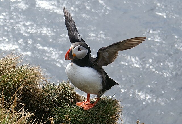 Puffin on Lundy Island
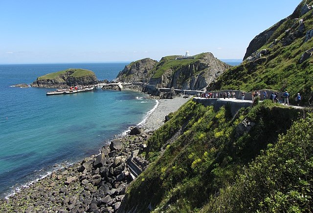 The Landing Beach
The finest coastal scenery and bird life on the island lies along the Westside Path. Here is the curious rift, some 80 feet deep, known as the Earthquake. This feature was reputedly created by tremors from the Lisbon earthquake of 1755. Three types of heath constitute much of the wild foliage at this point. Common heather, or ling, with small pink flowers; Bell heather with purple flowers and cross-leaved heath with bell like pink flowers. Punchbowl Valley follows and is so named because of the hollowed out saucer shaped stone found near the bed of the stream.
Jenny's Cove marks one of the best areas to view the sea birds that breed here from March to August. Look out for puffins, razorbills and guillemots. Kittywakes, fulmars and many other types of gull are seen all year round.
Just before the Halfway Wall is a pinnacle like formation of granite called the Cheeses. From this point it is the natural history of the coast and cliffs that becomes the major attraction. The carpets of sea pink are quite outstanding during May and June. The Threequarter Wall is followed by a splendid view of the impressive 400 foot granite slab of Devil's Slide. Wild goats inhabit these cliffs, while dolphins and grey seals frequent the waters below. The North Light marks the northern end of the walk.
On the East Coast, Sika deer, introduced in the 1920's, live in the dense rhododendron thickets, generally appearing only at dawn or dusk. The brown Soay sheep are more prominent, as are the Lundy ponies - now an officially recognised herd. These are a handsome dun colour and originally a cross between New Forest and Welsh Mountain ponies. Lundy is on the western migratory route for birds and in spring and autumn unusual species may be spotted. In spring many warblers arrive, while in autumn breeding birds from North America, such as the blackpoll warbler and American robin have also been recorded.
On the track to the main street of the village are cottages and farm buildings, and the working brewery. In front of the Marisco Tavern lies a long granite stone said to have been the lid of a grave that contained giant human bones. Two enormous skeletons were unearthed in 1851; of a man estimated at eight and a half feet, and one of a woman at seven and three quarter feet. The age of the bonds was never established, and they were reburied in the cemetery near the old lighthouse.
Acknowledgments: Text derived from the Out and Out Series; Discovering the Countryside on Foot. Pictures courtesy of Wikipedia.


