Bodinnick, Penleath Point, Pont Pill Creek and Lanteglos-by-Fowey
From a novelist's village to fabulous views over the Fowey Estuary
Google Maps Open Source Maps| Statistics and Files | ||
|---|---|---|
| Start: Bodinnick | Distance: 4.6 miles (7.4 km) | Climbing: 335 metres |
| Grid Ref: SX 12970 52423 | Time: 2-3 hours | Rating: Hard |
| GPX Route File | Google Earth File | About Fowey |
| Statistics | |
|---|---|
| Start: Bodinnick | Distance: 4.6 miles (7.4 km) |
| Climbing: 335 metres | Grid Ref: SX 12970 52423 |
| Time: 2-3 hours | Rating: Hard |
| GPX Route File | Google Earth File |
Ordnance Survey Explorer Map (1:25,000)
The Walk: The charming village of Bodinnick overlooks the estuary of the River Fowey, and the view to its south-west is commanded by the town of Fowey on the opposite bank. Drowned by land-tilt long ago, the river valley forms a natural deep-water, sheltered harbour that is home to countless yachts and part of an important seafaring highway. Cornish china clay has left this harbour for destinations all over the world for centuries.
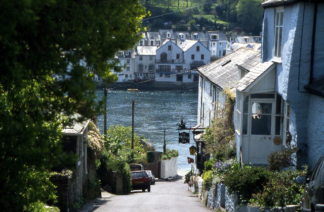 The view to Fowey from Bodinnick
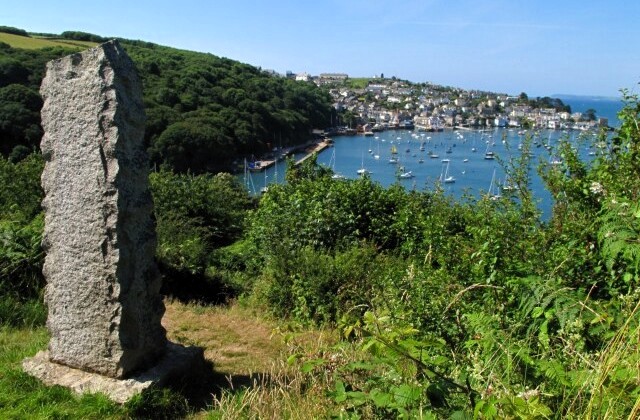 The view from Penleath Point to the Fowey Estuary
The village owes its existence to the water. It's ferry, formerly a cumbersome rowing boat, was recorded as far back as 1344. A vital commercial link in the old, southern route through Cornwall, the boat conveyed people, livestock and large consignments of beer. Ferry rights were once owned by the local Mohun family of Hall. Later, rights passed to the Passage House Inn, now the Old Ferry Inn. As you walk down to the ferry, look out for a house called Ferryside, beyond the slipway. This was once the home of Daphne de Maurier, and is still owned by the family. It was here that she wrote her first novel, The Loving Spirit.
Leaving the waterside, you walk up Bodinnick Hill, past the Old Ferry Inn. Further up, a plaque on the wall of Hall Walk Cottage shows the way onto the historic Hall Walk, a private promenade created by the Mohun family in the 16th century. Charles I, walking here during the Civil War siege of Fowey, saw one of his men killed by a musket shot fired from across the river.
At the confluence of the River Fowey and Pont Pill Creek stands a monument to the Cornish writer and scholar Sir Arthur Quiller-Couch, famous for his novels, in which Fowey is 'Troy', and as the compiler of the Oxford Book of English Verse. He became mayor of Fowey in 1937, and is buried there.
The thick woodland that clothes the slopes of Pont Pill is surprisingly recent. Until 100 years ago, the steep hillsides were grazed, but a change in land management - much of the area is now managed by the National Trust - has resulted in the natural regeneration of oak, ash, beech and sycamore.
The route passes a heronry in the woods and, as you drop down the hill from Hall Walk to the sleepy hamlet of Pont Quay, you may see buzzards and nesting swans. By crossing a wooden footbridge that links the stone quays on either side of the creek and ascending the hill ahead, you come to the door of the lovely church at Lanteglos-by-Fowey. The church is dedicated to the Christian hermit St Wyllow, who it is thought was murdered close to the head of the creek, a martyr to his faith. Much of the church dates from the 14th century, thought a few Norman fragments survive.
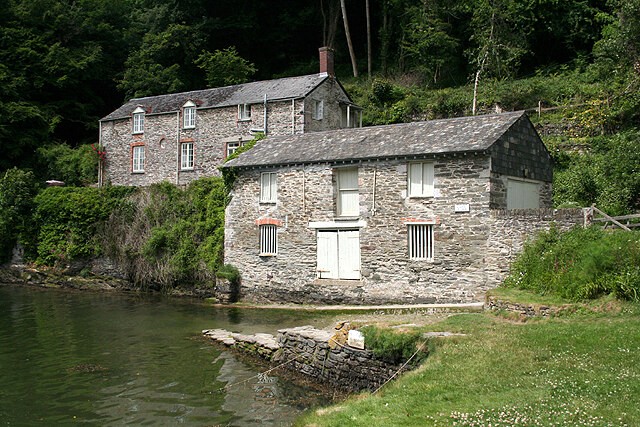 Buildings beside Pont Pill Creek
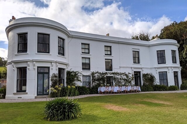 Porthpean House
The route loops round a narrow lane, field paths, and a road. When the road crosses the river, look upstream from the bridge to Porthpean House, once the site of Gragon Leat, which for centuries powered the wheels of a tucking (or fulling) mill. First recorded in 1331, locally spun cloth was cleaned and dressed here until the 18th century, when the mill was converted to paper making. The settling tanks used in making paper are now covered by the lawns of the house.
More signs of ancient country industry appear further along the road. The remains of a smithy and limekiln, and Lombard Mill, which dates from 1298, tell of a thriving local community long gone.
Climbing out of Pont to rejoin the tail end of Hall Walk, the going gets harder. After bearing right on a footpath by a slate cattle grid, it becomes tougher still, rising to over 300 feet (91 metres). There are fine panoramic views to all points of the compass ahead, and a little below, Hall Farm sits on the site of the former Manor of the Mohuns, which was destroyed in the Civil War.
The estate was later bought by Thomas Pitt, grandfather of Prime Minister William Pitt the Elder, but little of the original buildings has survived, save the remains of the 14th century Chapel. Beyond Hall Farm, the path dropped steadily down to the start of Hall Walk and on back to Bodinnick, and the starting point of the walk.
Acknowledgments: Text derived from the Out and Out Series; Discovering the Countryside on Foot. Pictures courtesy of Wikipedia.


