Avebury Stone Circle, Silsbury Hill, West Kennett Long Barrow, Sanctuary Stone Circle and Overton Down
A walk exploring Britian's finest collection of prehistoric monuments
Google Maps Open Source Maps| Statistics and Files | ||
|---|---|---|
| Start: Avebury Church | Distance: 8.6 miles (13.9 km) | Climbing: 164 metres |
| Grid Ref: SU 09938 70003 | Time: 4 hours | Rating: Easy |
| GPX Route File | Google Earth File | About Avebury |
| Statistics | |
|---|---|
| Start: Avebury Church | Distance: 8.6 miles (13.9 km) |
| Climbing: 164 metres | Grid Ref: SU 09938 70003 |
| Time: 4 hours | Rating: Easy |
| GPX Route File | Google Earth File |
Ordnance Survey Explorer Map (1:25,000)
The Walk:
The largest henge and stone circle in the British Isles are set within a tranquil Wiltshire vale. A settlement sprang up within the standing stones and grew to become the village of Avebury.
In 1649, Avebury was discovered by the diarist and author John Aubrey, who wrote, "it does as much exceed in greatness the so renowned Stonehenge as a cathedral doth a parish church". He had no idea who had constructed it, nor could he have foreseen its near destruction within the next century.
Fortunately, William Stukeley, an antiquarian, was equally captivated by the place , and spent seven years making meticulous notes and drawings of what he called "that stupendous temple, the most august work at this day upon the globe of the earth". He witnessed the toppling and smashing of many great stones by builders extending the village. His work provides an invaluable insight into what has been lost, and inspired a partial restoration of the site in the 20th century. It helped archaeologists to prove that the Avebury complex was a national monument when it was laid out over 4,500 years ago.
The Avebury we see today would not exist without the work of Alexander Keiller. This Scot, from the famous Dundee marmalade family, gave his personal fortune and the most active years of his life to restoring what he saw as Britain's most important archaeological site. Impressed by Stuckley's book on Avebury, Keiller started excavating the area in the late mid 1920's, buying up land even when no trace of ancient monuments remained above the soil. He helped prevent the building of a planned Marconi wireless station and tower, and slowly acquired the land on which ancient Avebury stood. Most of the stones seen today were located underground by skilled teams, and were carefully raised into their former positions, where most of them had not been seen for centuries. Alexander Keiller died in 1955, and as a final act of goodwill he left all the land he had acquired to the National Trust, in the hope they would complete the restoration.
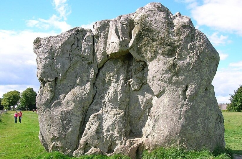 Devil's Chair, Avebury Stone Circle
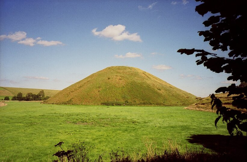 Silbury Hill
Today, Avebury is listed by the United Nations as an International Heritage Site. Unlike Stonehenge, one can still roam freely here, touch the surviving stones and clamber up and down the banks. Walking around Avebury is an unforgettable experience. The surrounding downland is both beautiful and unspoilt, and the impact of the site increases as you leave cars and crowds behind and look back over the complex from the surrounding hills.
Medieval Christians saw Avebury as the work of the devil. Stukeley's drawings show that stones were arranged in the form of a serpent passing through the main circle. At Avebury Church, where the walk begins, the Norman font bears are carving of a Bishop who is stabbing one of a pair of winged serpents in the head with his crozier.
The standing stones are called 'sarsens', a corruption of saracen, meaning non-Christian. A concerted effort was made to remove these pagan survivals towards the end of the Middle Ages. Many of them were toppled into pits and buried.
The stone circles predate Stonehenge by at least 500 years. Many of the latter stones came from this area. Both centres were built over several generations in the transitional period between the Stone Age and the Bronze Age, by people who lived close to the henges. Their only tools were stone axes, deer antler picks, blade-bone shovels, wicker carrying baskets, leather ropes and logs to lever, or roll, the massive stones.
They began by digging a circular ditch with high banks, 4,439 feet (1,353 metres) in circumference and 60 feet (18 metres) high. Grey-wether's, flat stones, that from a distance resemble recumbent sheep, were selected from several miles away and hauled down the ancient tracks to be set into four circles within the henge.
The largest stone, the Devil's Chair, is 23 feet (7 metres) long and weighs over 20 tons. An obelisk 18 feet (5.4 metres) high was set like the pin of a sundial within the southern circle; at the centre of the northern sector, a cove was created from three enormous megaliths.
An avenue of paired stones was constructed next, running southwards from the circles. Each pair consisted of a lozenge-shaped and a pillar-shaped stone, and some archaeologists believe that they symbolise male and female.
The route south goes along the River Kennet, past an even older construction than the stone circles and avenues. The 130 foot (39 metre) mound known as Silbury Hill is larger than many of the pyramids of Egypt. It would have taken 700 labourers 10 years to complete.
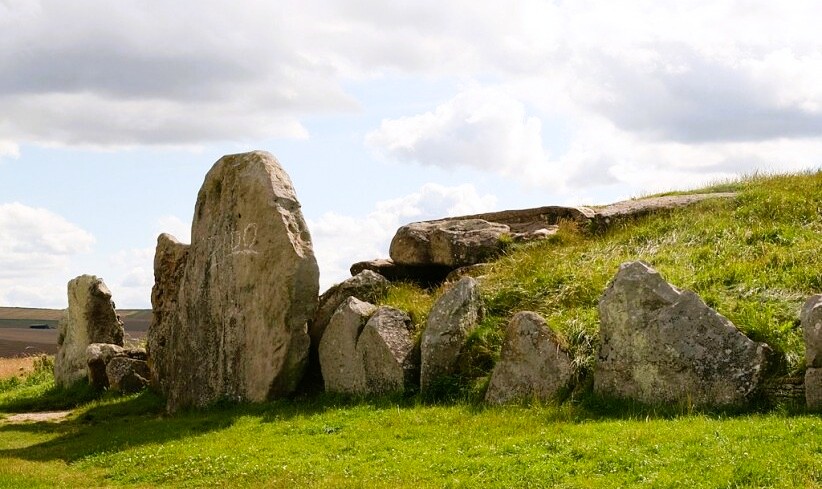 West Kennett Long Barrow
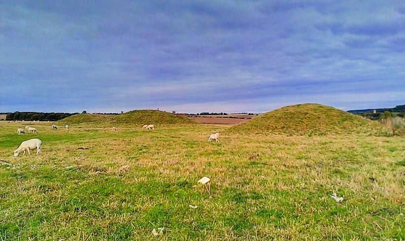 Ancient Barrows on Overton Down
On the other side of the A4 road, which follows the course of a Roman road at this point, is West Kennett Long Barrow, about 330 feet (100 metres) long. It is the second largest barrow in England and is 1,000 years older than the other monuments around. The stone chambers inside contained bones from people crippled by arthritis.
Curiously, the only complete skeleton found came from a man who was placed by the entrance before the chambers were sealed, around 2,000 BC. This was after the completion of the stone circles at Avebury when a new tradition of round Barrow burials began. His death may have been a sacrificial one; an arrow head was found in his neck.
Further along is The Sanctuary, which was the end of the stone avenue from Avebury as well as the head of Stukeley's serpent. A circular hut ringed by stones stood on this hilltop site. A large number of human bones have been found here in what was perhaps a communal burial ground.
From The Sanctuary, the route heads north along the Ridgeway, an ancient track some 5,000 to 6,000 years old. A steady climb, marked by tumuli, takes you on to the dawns where larks rise over a timeless landscape of pastures and crop fields. There are good views away to the left over Avebury and Silbury. And closer to you, just off the track, is a row of ancient round barrows.
Look north from the summit of Overton Down, towards Monkton Down, or east to Fyfield Down, and you should see some grey-wethers. The return to Avebury follows the Herepath, the ancient track along which the sarsens that made up the four stone circles were hauled.
Acknowledgments: Text derived from the Out and Out Series; Discovering the Countryside on Foot. Pictures courtesy of Wikipedia.


