Cremyll, Mount Edgcumbe, Kingsand, Cawsand and Empacombe House
A walk around a Cornish peninsula which overlooks Devon's greatest city
Google Maps Open Source Maps| Statistics and Files | ||
|---|---|---|
| Start: Cremyll | Distance: 6.6 miles (10.7 km) | Climbing: 327 metres |
| Grid Ref: SX 45218 53371 | Time: 3 hours | Rating: Moderate |
| GPX Route File | Google Earth File | About Cremyll |
| Statistics | |
|---|---|
| Start: Cremyll | Distance: 6.6 miles (10.7 km) |
| Climbing: 327 metres | Grid Ref: SX 45218 53371 |
| Time: 3 hours | Rating: Moderate |
| GPX Route File | Google Earth File |
Ordnance Survey Explorer Map (1:25,000)
The Walk:
From the high ground of Mount Edgecumbe Country Park, there are spectacular views over the water to the historic city of Plymouth. Countless vessels, from rowing boats to naval warships, ply the deep channels of Plymouth Sound. The water hubbub of the city dominates the scene, but never spoils the tranquility of the park.
Mount Edgecumbe Park covers about 165 acres. The land came into the ownership of the Edgecumbe family in 1479. The house they built here in 1533 was virtually destroyed by incendiary bombs in World War Two. The present building is a faithful replica.
Mount Edgecumbe's greatest glory, though, is its garden, the oldest landscaped park in Cornwall and scheduled as a Grade One Historic Garden. The garden's finest feature is its trees. There are unusual species such as Japanese cedar and cork ork, but even common trees like sycamore assume a new majesty from their sheer size.
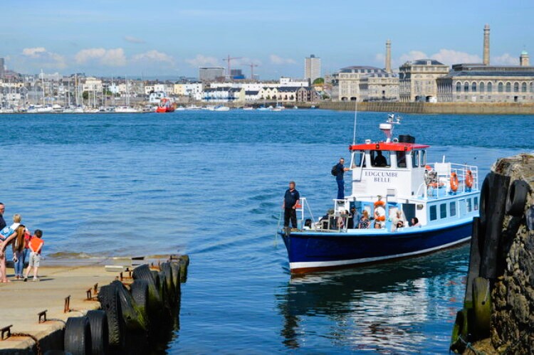 Cremyll Ferry
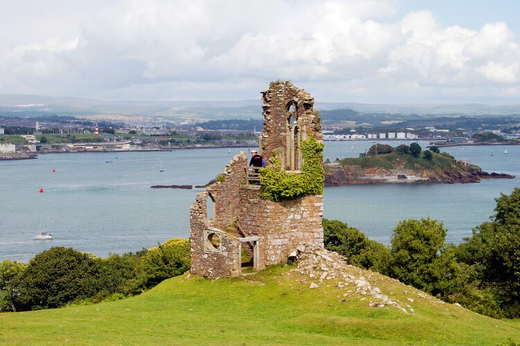 Folly in Mount Edgcumbe Park
The whole day could be spent wandering around the formal gardens, marvelling at the 600 or more species that make up the famous collection of the International Camellia Society, or pondering the problem of clipping the magnificent 17th century hedge. However, there are other delights to be discovered on the Maker Peninsula.
The first half of the walk skirts the estate on the coastal path. Beyond the Blockhouse, where the battery of cannons defended the channel through the Sound, is a large natural bowl surrounded by trees and planted with ornamental shrubs. On the far side is the Classical Milton's Temple, named for the inscription it bears from 'Paradise Lost'.
Look out for a large conifer with a straight, reddish trunk. This is a coast redwood which can live for well over 1,000 years and become one of the largest living organisms on earth. This one, despite its size, is still a youngster.
Beyond the amphitheatre, the path climbs and becomes wilder as it enters the high fenced deer park. Fallow deer here roam the woods, but are rarely seen in summer as they search out secretive places for their fawns. The romantic ruin just inside the park was built around 1747.
The woodland becomes richer and thicker between Ravenness and Reading Points. Inland of the path, camellias eucalyptus and even large palm trees and mimosa grow.
The protective arc of the quay wall to Fort Picklecombe, which was built in 1848, can be seen far below, as you round Picklecombe Point. The fort, now converted into secluded private flats, was one of a series protecting Plymouth harbour and dockyards. The best view of it is from further along the route.
Gaps in the trees reveal the wooded slopes of Penlee Point, one a half miles away across Cawsand Bay. The woods were planted for game hunting by the Edgecumbe family early in the 19th century.
Beyond the woodland, you crossed the grassy Minadew Brakes, where wildflowers abound. Yellow spires of agrimony, thistles and a pink vetch appear through the tangle of bramble and wild honeysuckle. Gatekeepers, common blues and speckled woods are among the butterflies abundant here in July.
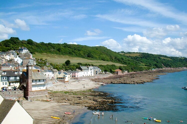 Cawsand
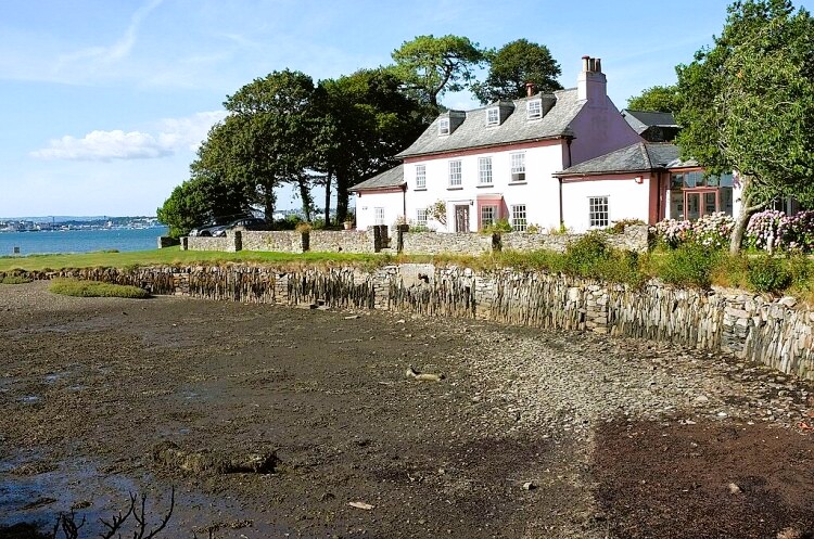 Empacombe House and Quay
The mid-point of the walk is at the twin villages of Kingsand and Cawsand. The stream running between them once formed the boundary between Cornwall and Devon. Revisions in 1844 restored the whole peninsula to Cornwall.
Leaving Kingsand, the route climbs steadily past the disused Grenville Battery, and reaches just over 350 feet (110 metres) close to Maker's church, whose 70 foot (21 metre) tower is clearly visible from land and sea for miles around. There is a view north of the urban sprawl up the banks of the River Tamar, past Devonport Dockyards to the Tamar road-bridge and Brunel's railway bridge. On the horizon, beyond are the masses of Bodmin Moor and Dartmoor.
A short detour takes you to St Julian's Well, dedicated to the patron saint of ferrymen. The ancient trough, fed by a natural spring, is right on the roadside and the restored stone well-house just behind looks like a tiny chapel.
You descend through Pigshill Wood to a muddy creek known as Millbrook Lake, pass the derelict tower of an old windmill, and arrive at Empacombe Quay. It was here that John Rudyerd based his shore workshops for the building of the Eddystone lighthouse in 1706-09. Rudyerd's achievements were eclipsed by John Smeaton's more famous tower half a century later.
At one time, the quay and adjoining Empacombe House were the property of the Edgecumbe estate, and the present Earl lives in one of the houses here. At low tide, you can see the extensive mudflats which provide a feeding ground for a wide variety of birds.
A little way round the coast, close to the car park at Cremyll, is an obelisk which was moved from the site of the folly seen earlier. It was supposedly commissioned by a countess to commemorate her pet pig. A lavish memorial to so humble a creature was considered so inappropriate by her heirs that they re-sited it outside the grounds.
The Cremyll Ferry has been an important link to Plymouth for at least 600 years and is still in service. The site marks the shortage crossing, and in the past was the traditional southern gateway to Cornwall. Centuries ago, there was a much larger settlement here known as West Stonehouse, but it was raised by the marauding French in 1350. The boatyard here dates from the 18th century and still produces very fine vessels under its modern ownership. Francis Chichester's yacht 'Gypsy Moth IV' was fitted out here prior to his solo round the world voyage.
Acknowledgments: Text derived from the Out and Out Series; Discovering the Countryside on Foot. Pictures courtesy of Wikipedia.


