Gorran Haven, Gorran Churchtown, Treveor, Porthluney Cove and Dodman Point
A walk on country lanes and along a thrilling clifftop path
Google Maps Open Source Maps| Statistics and Files | ||
|---|---|---|
| Start: Gorran Haven | Distance: 8.1 miles (13.1 km) | Climbing: 505 metres |
| Grid Ref: SX 01045 41543 | Time: 4 hours | Rating: Hard |
| GPX Route File | Google Earth File | Gorran Haven |
| Statistics | |
|---|---|
| Start: Gorran Haven | Distance: 8.1 miles (13.1 km) |
| Climbing: 505 metres | Grid Ref: SX 01045 41543 |
| Time: 4 hours | Rating: Hard |
| GPX Route File | Google Earth File |
Ordnance Survey Explorer Map (1:25,000)
The Walk:
This walk to the wild headland of the Dodman takes in some very finest coastal scenery in south-west Britain, but it begins in very different surroundings, the modern housing of the sleepy village of Gorran Haven.
It takes a while to leave the newer sprawl behind, but once you are on the path to the smaller settlement of Gorran Churchtown, reminders of the present begin to slip away.
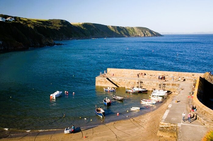 Gorran Haven Harbour
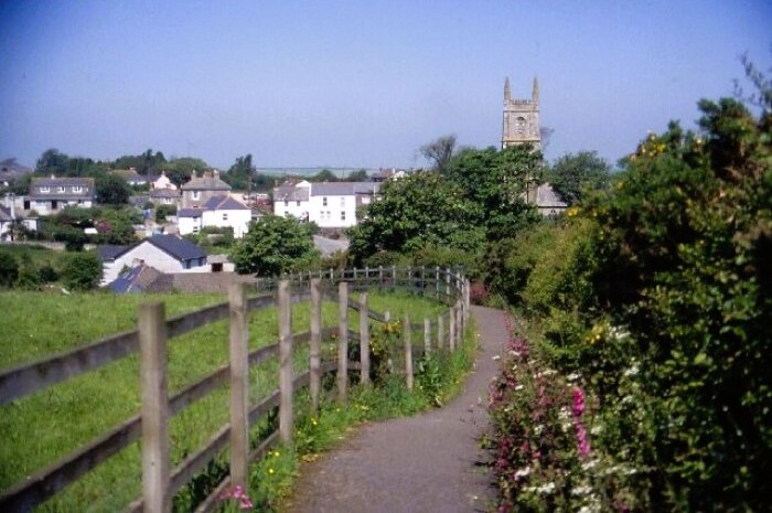 Gorran Churchtown
As you cross the table-top landscape towards Treveor, you will see that many of the old stone stiles are topped with curious granite columns laid on their sides. These are the remains of old field rollers.
The walking is easy here, and remains so to beyond Tregavarras. But the appearance of Caerhays Castle, which is splendidly set on a wooded hillside at the head of a tiny sandy cove, heralds a change.
Caerhays Castle owes its neo-Gothic look to John Nash, who converted it on behalf of the Trevanion family. Nash remains best known for redesigning Buckingham Palace, and for his imposing curved terraces in London's Regent Street. Oddly, he chose papier-mache as the roof covering for Caerhays, defying the Cornish climate to do its worst. It did, and the castle was abandoned to the ducks in 1852. It was bought and restored by a Michael Williams, whose descendants still live there.
Away from Caerhays Castle, the coast path starts to rise steeply. More than 130 steps climb high over Black Rock, giving spectacular views on a clear day. The huge radio dishes of Goonhilly Downs are visible beyond Gull Rock, over 20 miles (32 kilometres) away on the Lizard peninsula.
The National Trust owns substantial stretches of the local coastline, including Dodman Point itself. The first section to be encountered, after taking a breather to cast your eye over the sands of Porthluney Cove, is Lambsowden Cove, on the way towards the unmistakable jagged outline or Greeb Point.
Veryan Bay as a whole has long had a notorious reputation among sailors - almost every headland, it seems, has been the scene of a maritime catastrophe. In 1838, the brig Brandywine struck the rocks at Greeb Point with great loss of life. Its cargo, hundreds of barrels of brandy, was washed ashore and the ensuing race between the locals and the authorities to salvage the contraband was won by the Revenue Men.
The path undulates between stunted sycamore, hawthorn and elder. Blackthorn thickets often provide a welcome boundary between the steeper cliff edges. See spleenwort can be found in the area, and the rare, narrow-leaved everlasting pea is known to occur. Great black-backed gulls, marauders of the seabird colonies on Gull Rock, sometimes sweep by. In winter, there may be the occasional refugee black-throated or great northern diver in the bay.
As you walk above Hemmick Beach, the grandeur of the Dodman begins to show as the headland bulks before you. From here, the path rises fairly severely, in parts as steeply as it is possible to walk without scrambling.
Further on, the gradient eases a little, but the ascent is generally relentless. At the top you stand 374 feet (114 metres) above the sea. From here, you can see how the Dodman commands the eastern end of the great scoop of Veryan Bay. To the west there are views to the Lizard peninsula; to the east, Looe Island can be picked out against the sweep of coast stretching as far as Rame Head near Plymouth.
The dizzying height is felt more strongly at the Stone Cross, where the cliffs fall away to the crashing sea. The original cross was cut from a huge chunk of granite and erected in 1896 by the rector of St Michaels Caerhays, as a navigational aid. Such as the prominence of its position that it was soon struck by lightning and shattered. It has since been repaired.
 Porthluney Cove
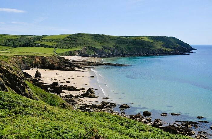 Dodman Point
Just a little way inland from the cross, a tiny watchhouse stands close to the path, now restored as a shelter for walkers. It was once one of a chain of flag signalling stations set up by the Admiralty in the late 18th century. The flagpole fell in the storm, but its anchoring shackles can still be found in nearby rocks. The rusty iron bar in the low turret next to the 'house' once supported a telescope mount.
As the path opens out into a large, grassy field, it passes close to a long, narrow field, bounded by stone walls. This is the survivor of the medieval strip field system of arable farming, and is one of many that once existed here.
Dodman Point has a long history of settlement. With the sea as an ally, and only one defensive line to maintain, Bronze and Iron Age settlers found the headland attractive, despite its exposure to the elements. The great bank across the neck of the headland, known as the Bulwark, defines the site of an ancient fort. The bulwark is not easy to pick out as you walk inland from the cross; it's 2,000 feet (610 metre) length is better appreciated from the air or the track from the hamlet of Penare.
However, where the path passes through it, part of the 20 foot (6 metre) banking fronted by a ditch can be clearly seen. Two Bronze Age barrows lie within the Bulwark's enclosure. One, close to the passage through the Bulwark, appears only as a very shallow hump fronted by a stone wall. But it has never been excavated and may be brimming with ancient bones and artefacts.
Vault Beach marks the path's curving descent from the Dodman to almost sea level. The home stretch, though, along the cliffs dotted with heather, thrift and ox-eye daisies, climbs again. Finally, the small harbour wall of Gorran Haven appears below to your left, as the path drops towards the sheltered beach and the old cottages of this once thriving fishing village.
Acknowledgments: Text derived from the Out and Out Series; Discovering the Countryside on Foot. Pictures courtesy of Wikipedia.


