Bosherston Ponds, Stackpole Head and Broad Haven Dunes
From secluded lakes of lilies to the drama of Pembrokeshire's cliffs
Google Maps Open Source Maps| Statistics and Files | ||
|---|---|---|
| Start: Bosherston | Distance: 7.8 miles (12.6 km) | Climbing: 450 metres |
| Grid Ref: SR 96610 94776 | Time: 4 hours | Rating: Moderate |
| GPX Route File | Google Earth File | About Bosherston |
| Statistics | |
|---|---|
| Start: Bosherston | Distance: 7.8 miles (12.6 km) |
| Climbing: 450 metres | Grid Ref: SR 96610 94776 |
| Time: 4 hours | Rating: Moderate |
| GPX Route File | Google Earth File |
Ordnance Survey Explorer Map (1:25,000)
The Walk: This walk starts in the village of Bosherston and first visits the lush lily ponds, once part of a great estate. The walk continues along quiet country lanes, ending above the high cliffs on part of the impressive Pembrokeshire Coast Path, rightfully classified as a National Trail. Bosherston was originally known as Stackpole Bosher, one of the retinue of Elidyr de Stackpole, who came to Britain with William the Conqueror. The church is substantially Norman of the late 13th century and it has some notable effigies, including a 14th century Crusader.
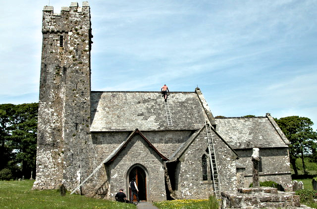 Bosherston Church
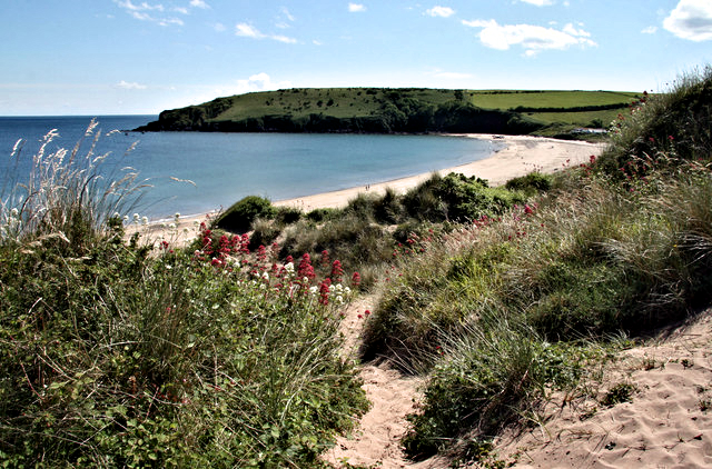 Coastal View to Trewent Point
The beautiful lily ponds were created in the 18th century to enhance the Stackpole Estate. There are pleasant, shaded walkways all through the woods at the water's edge and the paths are linked by a series of low footbridges across the ponds. Water fowl are abundant in the ponds all year round but summer is definitely the time to visit to best enjoy the wonderful array of water lilies in full bloom. The site of an iron age hill fort on the promontory is a reminder that there was a settlement here more than a thousand years before the Normans came.
The walk continues to Stackpole village and then on through gentle farming country to Trewent Point (Stackpole Quay). This sheltered spot has been given further protection by a simple stone quay, jutting out from the cliffs. It serviced the old limestone quarry nearby, for it was here that fuel for the lime kiln was landed, and stone from the quarry and lime were sent out around the coast. The path climbs to the top of the cliffs to join the National Trail. From here it is clear that Stackpole marks a distinct break in the nature of the coast. To the east the cliffs show rich reds and oranges typical of sandstone. to the west is grey limestone. This forms in blocks and horizontal bands, so that the cliff top is flat, and this combined with the short, springy turf makes for easy and pleasant walking. Erosion has created rock arches and isolated sea stacks and one good reason for taking the route around Stackpole Head is to get a good view of the great natural arches below the cliffs.
This first break in the cliffs appears at Barafundle Bay. The sand has piled up at the back of the beach to create high dunes, which the wind has whipped into strange shapes. This whole sandy area was once a vast rabbit warren, and the massive wall on one side of the bay separated the warren from the deer park. Another fine cliff-top walk is leads on to Broad Haven. The narrow line of dunes at the back of the beach divide it from the end of the Bosherston Ponds. It is here that the dam was built to hold back the water to create these sumptuous ornamental lakes.
Acknowledgment: Text derived from the Out and Out Series; Discovering the Countryside on Foot. Pictures courtesy of Wikipedia.


