Aberedw and Llewelyn's Cave
Seeking a prince in the hills of mid Wales above the Wye Valley
Google Maps Open Source Maps| Statistics and Files | ||
|---|---|---|
| Start: Aberedw | Distance: 4.1 miles (6.6 km) | Climbing: 300 metres |
| Grid Ref: SO 07636 47502 | Time: 2 hours | Rating: Moderate |
| GPX Route File | Google Earth File | About Llewelyn the Great |
| Statistics | |
|---|---|
| Start: Aberedw | Distance: 4.1 miles (6.6 km) |
| Climbing: 300 metres | Grid Ref: SO 07636 47502 |
| Time: 2 hours | Rating: Moderate |
| GPX Route File | Google Earth File |
Ordnance Survey Explorer Map (1:25,000)
The Walk: This is a pleasant walk in wooded and craggy country with impressive views of the Black Mountains and the Brecon Beacons. It also has historical connections with the medieval Welsh Price Llewelyn. The walk starts by Aberedw Church which was dedicated to Saint Cwydd, a brother of the 6th century historian Gildas. It is one of the finest churches in old Brecknockshire.
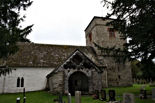 Aberedw Church
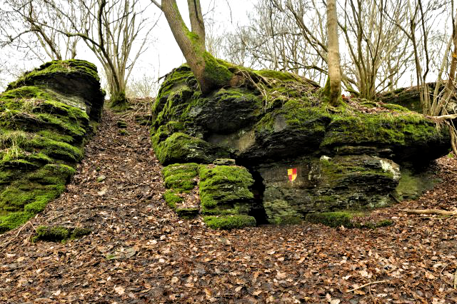 Llewelyn's Cave
Not far from the church lie the remains of Aberedw Castle. It is situated above the River Edw which rushes noisily below through a rocky gorge to join the River Wye. Built by the Norman lord, Radulphus de Baskerville, who came over to England with William the Conqueror. The castle was later used as a hunting lodge by Prince Llewelyn. Much of the castle site was destroyed when the Cambrian railway was constructed and stone from the castle was broken up and used as ballast.
In the year 1282, the English and Welsh were at war and Prince Llewelyn was on the run. He is said to have spent his last night alive in a cave now named Prince Llewelyn's Cave. Inside, the walls are scratched with the names and dates of the visitors who have been in the cave over the years. The legend relates that a local blacksmith reversed the shoes on the hooves of Llewelyn's horse so that the tracks on the snow would mislead his enemies. However, the blacksmith then sold this information to the English troops leading to his capture and beheading at Cilmeri near Bulith Wells, on a bleak December day in 1282.
The Aberedw Rocks are crags which are scattered over the hillside near the village. From the high point there is an excellent view southwards to the Black Mountains and Brecon Beacons, looming dramatically against the sky. The rocks are outcrops of Silurian limestone rising in terraces above the deep gorge cut by the River Wye. On these grassy heights there are grouse, skylarks, meadow pipits and wheatears to be seen. You may also hear the piped notes of a ring ouzel or catch a glimpse of a merlin. The biggest prize of all is to sight the red kite with its forked tail - the bird which gave its name to the toy because of its hovering skills.
Acknowledgment: Text derived from the Out and Out Series; Discovering the Countryside on Foot. Pictures courtesy of Wikipedia.
Feedback and Suggestions: To suggest a link for inclusion on a this page please complete the Walking Englishman Feedback Form. Thank you.