Llangollen, Castell Dinas Bran, Valle Crucis Abbey and Pillar of Eliseg
Above Llangollen and past the ruins of a 13th century Cistercian abbey
Google Maps Open Source Maps| Statistics and Files | ||
|---|---|---|
| Start: Llangollen | Distance: 7.5 miles (12.1 km) | Climbing: 537 metres |
| Grid Ref: SJ 21498 42047 | Time: 3-4 hours | Rating: Hard |
| GPX Route File | Google Earth File | About Llangollen |
| Statistics | |
|---|---|
| Start: Llangollen | Distance: 7.5 miles (12.1 km) |
| Climbing: 537 metres | Grid Ref: SJ 21498 42047 |
| Time: 3-4 hours | Rating: Hard |
| GPX Route File | Google Earth File |
Ordnance Survey Explorer Map (1:25,000)
The Walk: Limestone cliffs, stiff climbs up the grassy slopes of two shapely hills and the tranquility of a canal towpath combined to make this a varied walk. Although it is rich in legend, history and culture, nature is not to be outdone. Come in spring to see alder catkins hanging from the trees or enjoy a summer ramble with a company of lime loving common blue butterflies.
 Llangollen
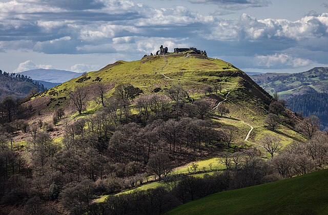 Castell Dinas Bran
Llangollen is the sacred enclosure of St Collen, who made his name in the 7th century for dealing with fairies. It is the bridge that finds its way into the old rhyme about the 'Seven Wonders of Wales', however. Originally a packhorse bridge built by John Trevor, Bishop of St Asaph, in 1345. It has been widened several times and the rapids below it are a testing ground for canoeists.
Llangollen Railway Station was on the Great Western Railway line from Ruabon to Dolgellau. It received its first train in 1862 and the line westward to Corwen opened in 1865, just a century before British Rail closed the route. Preservationists reopened the station in 1975 and the Llangollen Railway now runs steam and diesel hauled trains to Berwyn.
The limestone escapement of Trevor Rocks is an impressive sight. It began as a coral reef in tropical waters 350 million years ago. The Offa's Dyke Path follows this route on its journey of some 170 miles between Chepstow and Prestatyn, although the nearest stretch of dyke is actually the earlier Wat's Dyke, about six miles to the east.
There are splendid views all along this walk, but the best is seen from Castell Dinas Bran. Descending into the valley the path leads to the ruins of Valle Crusis Abbey. It was actually dedicated to St Mary, while the cross referred to in the valleys name is the nearby Pillar of Eliseg. The abbey was endowed by Madoc ap Grufydd Maelor, Prince of Powys Fadog (or North Powys) on the 28th January, 1201.
Its first monks came from Strata Marcella near Welshpool and were Cistercians, renounced for the hard work and self-sufficiency. Its resulting prosperity was affected by the Welsh wars, but it was peaceful and wealthy in the early 14th century.
The Black Death of 1349 was followed by Owain Glyndwr's fight for liberation, however. An old story tells of the Abbot of Valle Crusis meeting his neighbour Owain Glyndwr while taking an early morning stroll by the River Dee. Owain joked that the abbot was up early, but the abbot replied that it was Owain who had risen too soon - a century too soon. This was a prophecy of Henry Tudor's victory at the Battle of Bosworth in 1485. The Tudors were later to dissolve the abbeys, but the number of monks had dwindled in number and had lapsed from the structured Cistercian rules by the time Valle Crusis was closed in 1537 after the Dissolution of the Monasteries. Its ruins are now in the care of Cadw (Welsh Historic Monuments).
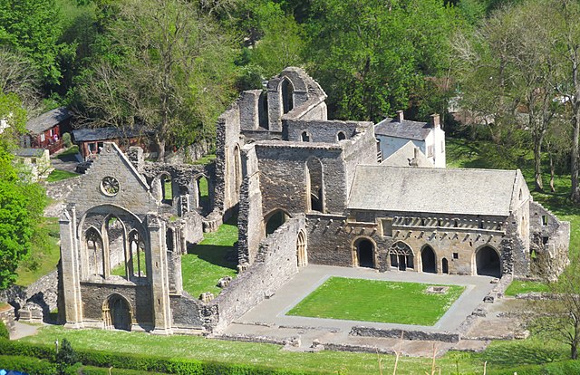 View to Valle Crucis Abbey from Velvet Hill
 Train crossing River Dee near Pentrefelin
The Pillar of Eliseg now stands eight feet high. It was broken during the Civil War and originally formed a cross of about twenty feet in height. This is the cross that gave its name to this valley and would seem to mark the crossing point of male and female Earth energy lines (The Mary and Michael Ley Lines). Its significance led to a man, possibly Eliseg, being buried here under the cross. The tumulus was opened up before the pillar was re-erected in 1779. It was found to contain the skeleton of a man, plus a silver coin, which would rule out an earlier date to his burial. The pillar is most famous for its Latin inscription. This is now indecipherable, but it was carefully transcribed by Edward Lhuyd in 1696. The thirty-one lines of Latin recorded that the stone was erected by Concenn, great grandson of Eliseg, who fought to save Powys from the English.
The next stage of the walk is the crossing of Velvet Hill, whose Welsh name, Coed Hyrddyn, means 'wood of the long man' which may relate to the tall skeleton unearthed beneath the Pillar of Eliseg. From the top of Velvet Hill stop a while to enjoy the breathtaking views eastwards to the neighbouring hill on which Castell Dinas Bran stands and to the Vale of Llangollen below you.
Come in early July to have a look at the tented pavilion on the grounds of the Llangollen International Musical Eisteddfod. Since 1947 this annual event has attracted singers, dancers and musicians from all over the world. The feast of colours is especially vivid on the Wednesday, when folk dancers take to the stage and can be seen practicing beforehand in the Eisteddfod grounds and around the town.
Celebrate the end of the walk with a leisurely cruise in a horse drawn barge. This starts from Llangollen Wharf, where there is an excellent canal exhibition. Notice the crane that has been carefully preserved outside. The Llangollen Canal is a branch of the Shropshire Union Canal and was completed in 18O5 by Thomas Telford.
Acknowledgment: Text derived from the Out and Out Series; Discovering the Countryside on Foot. Pictures courtesy of Wikipedia.


