Gospel Pass, Twmpa and Capel-y-ffin
A walk in the spectacular Black Mountains
Google Maps Open Source Maps| Statistics and Files | ||
|---|---|---|
| Start: Gospel Pass | Distance: 7.1 miles (11.4 km) | Climbing: 422 metres |
| Grid Ref: SO 23623 35058 | Time: 3 hours | Rating: Moderate |
| GPX Route File | Google Earth File | About Gospel Pass |
| Statistics | |
|---|---|
| Start: Gospel Pass | Distance: 7.1 miles (11.4 km) |
| Climbing: 422 metres | Grid Ref: SO 23623 35058 |
| Time: 3 hours | Rating: Moderate |
| GPX Route File | Google Earth File |
Ordnance Survey Explorer Map (1:25,000)
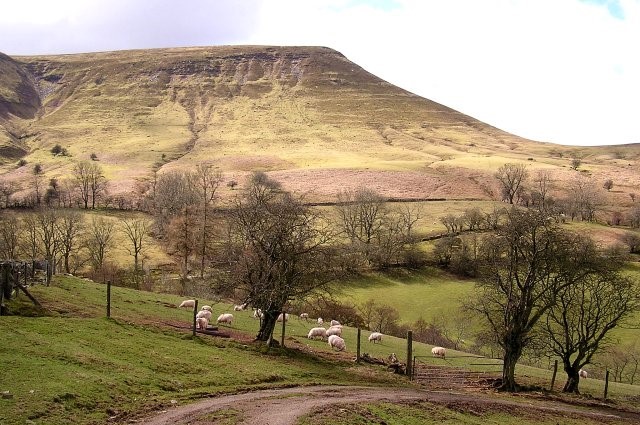
The Walk: This hill walking route crosses a summit over 2,000 feet high. It is an easy climb, however, since the ascent begins at the top of the mountain pass and it is rewarded with extensive views. The walk continues down the narrow and secluded valley of Nant-y-Bwch (Buck's Stream), a tributary of the River Honddu, to reach Capel-y-ffin. From there, the route ascends the lower slopes of the green dome of Darren Lwyd along a path around the side of the hill to meet the mountain road, which it then follows on a steady climb back to the start.
 Twmpa, Lord Hereford's Knob
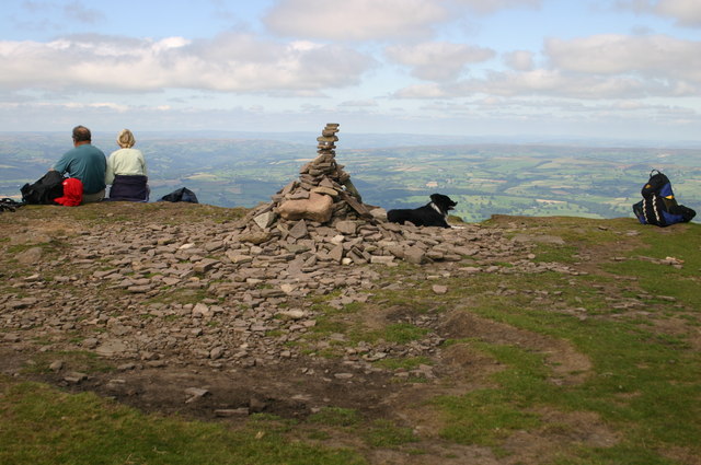 The summit of Twmpa
The narrow gap between Twmpa and Hay Bluff, which lies to the northeast, is known in Welsh as 'Bwlch-yr-Efengyl' or in English as 'Gospel Pass'. It was once considered to be hazardous because of the danger of ambush. According to legend, St Peter passed this way with his brother apostle Paul on the mission into Wales to evangelise the local people. However, it is most unlikely that either Saint came to Britain, the name is more probably derived from memories of the preaching tour of Archdeacon Baldwin, accompanied by Gerald of Wales, when they passed through the Black Mountains in 1188 exhorting men to join the Crusades.
Twmpa - sometimes called Lord Hereford's Knob - is 2,263 feet in height. From its summit there is a glorious view over wooded foothills to the Wye Valley as it curves in a great loop from Builth to Whitney. In the distance can be seen the Radnor Hills and the mountains of mid Wales. To the east may be glimpsed the Clee Hills and in the west the distinctive flat top summits of the Brecon Beacons.
Hey Bluff on the other side of Gospel Pass is the most northerly point of the Black Mountains and can provide even more extensive views on a clear day. It is also a popular launching spot for hand gliding and paragliding enthusiasts who make good use of the thermals to soar above the escarpment, floating gently down to land on the flat area of Hay Common directly below.
Near the southern tip of this walk, the monastery of Father Ignatius is encountered. It is not as old as it looks, for it was founded in 1870. The style of the church was copied from Llanthony Priory further down the valley. Father Ignatius lived here with his small community for some 38 years, broken only by preaching trips and missions both at home and abroad.
The Reverend Francis Kilvert, an Englishman who was curate at Clyro near Hay-on-Wye and a noted diarist, passed through the hamlet on one of his walks and saw the monks working in the garden of the monastery. He later reflected in his diary that there must have been very hot in their black habits and that their way of life seemed very unnatural, since they did not allow women even to do their washing.
In 1924 the artist Eric Gill came to live at the Capel-y-ffin monastery and he had left his mark in the form of sculptured stones in the village churchyard. Together with his family, he founded the self supporting Catholic community of the Ditchling Guild.
Today, the monastery is no longer inhabited by hooded monks, but it has for many years been a private residence. A small attic chapel however, is open to the public and services are sometimes held there. The ruins of the Abbey Church are maintained by the Father Ignatius Memorial Trust.
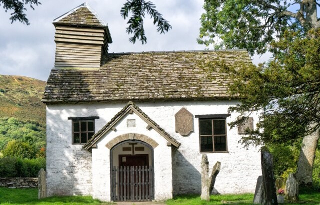 Capel-y-ffin Chapel
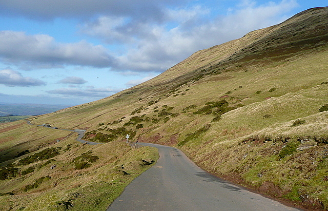 Gospel Pass
The name Capel-y-ffin means 'chapel of the boundary' and the little church that bears this name was built in 1821 beside the River Honddu, near the point where the boundaries of the old counties of Monmouthshire and Breconshire met. It has a small wooded louvered belfry leaning at an angle. The quaint little building was described by the reverent Francis Kilvert in his diaries. He wrote that the church reminded him of an owl. It is set in a circle of ancient yews and there are several memorial stones that make fascinating reading.
A short distance away on the other side of the River Honddu is the Capel-y-ffin Baptist Church, which is also worth a visit. It was established in 1737 by William and David Pross. Most of the tombstone descriptions are in Welsh, but one that is in English touchingly commemorates Susannah, wife of James Watkins of Sychtra, Cwmyoy. It reads:
This lovely rose, so young and fair
Was called by early doom
Just to show how sweet a flower
In Paradise would bloom
After Capel-y-ffin, the walk passes an attractive former farmhouse that was converted into a youth hostel. Situated at an altitude of 1,300 feet, the hostel is comfortable and popular with YHS members who pass here. Beyond the hostel the walk is a straightforward journey along the length of Gospel Pass, all the way back to the start at the car park.
Acknowledgment: Text derived from the Out and Out Series; Discovering the Countryside on Foot. Pictures courtesy of Wikipedia.


