Coed Rheidol, Devil's Bridge and Parson's Bridge
A walk through oak-clad slopes and over prehistoric moorland
Google Maps Open Source Maps| Statistics and Files | ||
|---|---|---|
| Start: Devil's Bridge | Distance: 6.9 miles (11.2 km) | Climbing: 571 metres |
| Grid Ref: SN 74195 77053 | Time: 3-4 hours | Rating: Hard |
| GPX Route File | Google Earth File | Devil's Bridge |
| Statistics | |
|---|---|
| Start: Devil's Bridge | Distance: 6.9 miles (11.2 km) |
| Climbing: 571 metres | Grid Ref: SN 74195 77053 |
| Time: 3-4 hours | Rating: Hard |
| GPX Route File | Google Earth File |
Ordnance Survey Explorer Map (1:25,000)
The Walk: Of all the vales in Wales, the Vale of Rheidol is arguably the most attractive. Its chief asset is its steep slopes clad in native sessile oaks. The views through these trees make a ride on the stream train from Aberystwyth a memorable experience. Countless visitors have come to the Vale of Rheidol, all to marvel at the dramatic falls below Devil's Bridge, as did William Wordsworth in 1824. He was astounded that "such a force of water issues from a British source". The falls are the meeting place of Afon Rheidol and Afon Mynach and are best seen from below. Here is spectacular scenery, wildlife in abundance, enigmatic remains from prehistory and a famous legend.
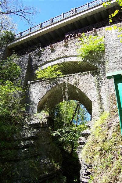 Devil's Bridge
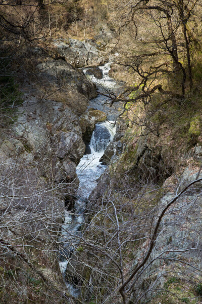 Afon Rheidol
The walk begins on Devil's Bridge. This is a place to provide for generously, both in time and money. A visit to its nature trail could extend the walk by well over an hour, while the turnstiles for both this and the Devil's Punchbowl will make demands on your purse.
Strangely, one of the places most famous visitors, George Borrow (the author of Wild Wales, 1862) seemed more interested in the band of young robbers, known as the Plant De Bat, who used to live in a cave here rather than in the story of the bridge itself. However, he wrote that "if pleasant recollections do not haunt you through life of the noble falls in the beautiful wooded dingles... you must be a very unpoetical person indeed". But it was to be another 40 years before mass tourism really came to this area with the construction of a railway. The local lead mines welcomed a line down to the port, but when work started it was the transport of tourists from Aberystwyth that carried more weight.
The Vale of Rheidol Railway opened for goods traffic in August, 1902, with the first passenger trains running that Christmas. The lead mines were virtually dead by 1914 and the last freight train ran in 1926. Tourist traffic was encouraged by the provision of a charabanc to carry passengers from the Devil's Bridge terminus right up Plynlimon. When the Great Western Railway acquired the line in 1922 they invested in two new engines, Owain Glyndwr and Llewelyn. These still pull the trains along with the rebuilt original company's Prince of Wales. The Lein Bach was sold by British Rail to the Brecon Mountains Railway in 1989.
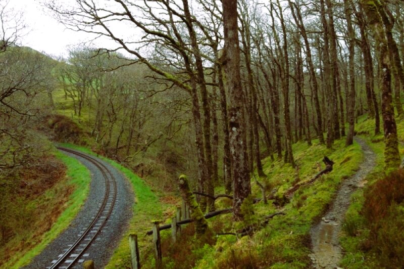 Railtrack and footpath in Coed Rheidol
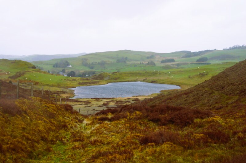 Bryn Bras Reservoir
The National Nature Reserve is formed mainly of sessile or Durmast oaks. Sessile, meaning stalkless, refers to the fact that the acorns sit tightly on the twigs without stalks. These trees covered most of the Welsh hills below 2,000 feet. Very few Welsh valleys have retained their trees, however, because of farming. But the sides of this gorge have defied the plough and the encroachment of sheep.
The Cwm Rheidol lead mine was connected to the railway via an aerial ropeway More lead mines are passed at Ystumtuen. Active from the 17th century to about 1900, the lead mines were served by the Bryn Bras reservoir, passed on this walk.
Ancient man valued these uplands too. The Temple Cairn Circle on Bwlch Gwyn may not be in the same league as Stonehenge or Avebury, but it is significant.
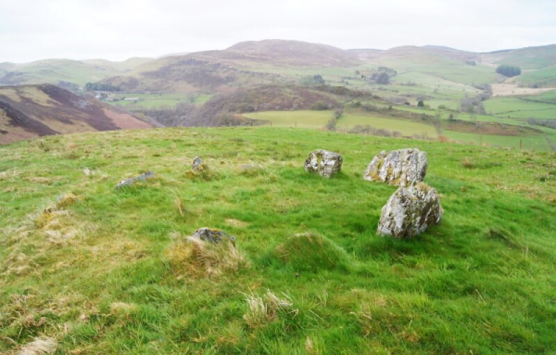 Temple Cairn Circle on Bwlch Gwyn
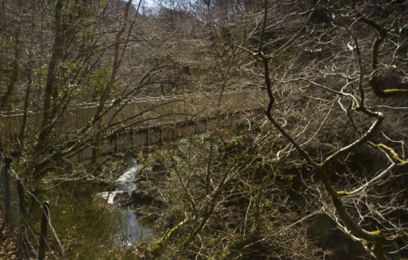 Parson's Bridge
Parson's Bridge refers to the place where the local parson had to cross the deep-cutting River Rheidol between Ystumtuen and Ysbyty Cynfyn. It used to be a swaying plank that hung from the sides of the gorge by chains until the present bridge was built in 1951.
The Church of St John the Baptist, Ysbyty Cynfyn, is where the first boundary hospice awaited pilgrims travelling to Strata Florida Abbey. 'Ysbyty' means hospice in Welsh. It may possibly be set within an ancient stone circle. Look too for some sad graves next to the railing around a yew tree to your left as you face the church porch. The graves include the first record of quadruplets. All four; Margaret, Elizabeth, Catherine and Isaac died within six days of their birth to Margaret Hughes on the 17th February, 1856. Typhoid was rampant and their elder brother Hugh, joined them on 1st March, 1856, followed by their father, Isaac Hughes, (aged 32) on the 6th March and his daughter Hannah (aged 3) on the 10th March. Of the entire family, only the mother survived.
Although there is not much to see now, Bodcall Woollen Mill was active in the 18th and 19th centuries. It was fed by water taken upstream of the nearby miniature gorge.
See my Vale of Rheidol Walk
Acknowledgment: Text derived from the Out and Out Series; Discovering the Countryside on Foot. Pictures courtesy of Wikipedia.


