Aberdulais Falls
Spectacular waterfalls, a site of historic interest, woodland and hills
Google Maps Open Source Maps| Statistics and Files | ||
|---|---|---|
| Start: Car Park | Distance: 4.5 miles (7.2 km) | Climbing: 232 metres |
| Grid Ref: SS 77110 99308 | Time: 2 hours | Rating: Moderate |
| GPX Route File | Google Earth File | About Aberdulais |
| Statistics | |
|---|---|
| Start: Car Park | Distance: 4.5 miles (7.2 km) |
| Climbing: 232 metres | Grid Ref: SS 77110 99308 |
| Time: 2 hours | Rating: Moderate |
| GPX Route File | Google Earth File |
Ordnance Survey Explorer Map (1:25,000)
The Walk: At first sight, this is a typical South Wales valley, with its terraced houses and no fewer than three chapels huddled together looking, somewhat disapprovingly it seems, at the pub across the road. Crowded into the narrow valley floor are the main road, the railway and the Neath and Tenant Canal. Yet just across the road, you can step straight into as romantic and wild a scene as you could wish to find. From the road bridge you can see the solitary remaining arch of an older bridge across the River Dulais.
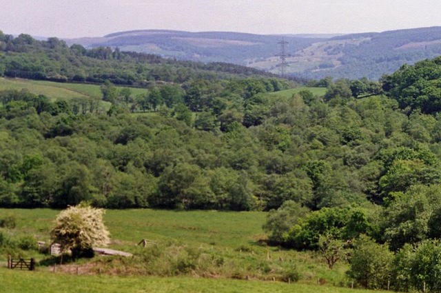 Countryside near Aberdulais
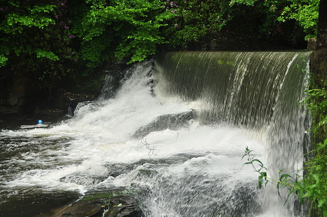 Aberdulais Falls
Aberdulais Falls and their surroundings are now in the care of National Trust and a major renovation scheme was completed in the 1990's. Walkways provide splendid views of the falls and of the complex remains of the iron tinplate works of the last century, while explanatory boards helped the visitor to make sense of the site. There is something here for everyone; historical remains in a beautiful setting. The information centre has details of the industrial site on the ground floor and reproductions of some of the works of artists who came here, including JMW Turner.
After leaving the falls, the walk climbed steeply up the hillside, arriving almost immediately at a country lane, bordered by a hedge on one side and a stone wall on the other. The path leads past a farmyard, crosses the railway and arrives at the main road. Soon you can see woodland stretching round the hillside with a craggy crest look rising above it. The path leaves the roadside and now leads up into this woodland, which is laced with a network of way-marked footpaths.
Although at first the woodland is dominated by conifers there is none of the dense uniformity associated with so many modern forestry plantations. The tree cover is broken up by streams rushing down the hillside, and rocks burst through the undergrowth, so the scenery is constantly changing. The walks have been skillfully devised to fit in with their surroundings with locked steps held in place by wooden pegs, simple rustic railings and seats and shelters made out of split logs. The woodland itself is varied and there is an incursion of birch into the otherwise relentless pine.
As you climb higher up the hill, so the rocks become a more dominant feature. Along the way, there are glimpses of the scenery of the Vale of Neath and the hills beyond. Towards the end of the woodland section, a greater variety of trees appear, including beech and oak.
When the woods end, the walk brings you out to a hillside of rough grassland, bracken and gorse. There are reminders here of the industrial past of the region - the grassy mounds of spoil heaps can be seen and across the valley by the pylons is the chimney of an old mine. The overall effect, though, is of remote hill scenery.
The further you climb, the rougher and more rugged the scenery becomes - trees are bent by the wind, boulders scatter the hillside and dry stone walls straggle away into the horizon, and the view steadily opens out over rolling countryside. An unusual feature can be seen near the brow of the hill at Gelli-march Farm, where the dry stone wall has been pierced by an arch to allow the livestock through.
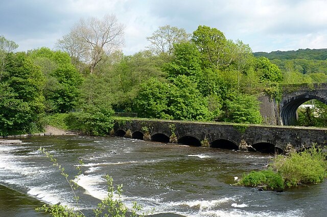 Aberdulais Aqueduct
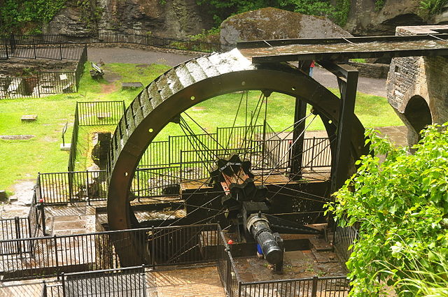 Aberdulais Waterwheel
The return to Aberdulais begins on a country lane that runs between dry stone walls, which are themselves interesting. The walls are topped by large overhanging flat slabs, kept in place by a haphazard jumble of heavy stones. This seems to be a very remote area where the grassland is broken up only by areas of reedy marsh.
Over to the right, you can see a very simple four-square stone farmhouse in an area of trees and stone walls. There is such a strong sense of remoteness that it comes as something of a shock to find the road running around the boundary of Neath Golf Course. Yet the well tended golf course has little impact; the scenery is still dominated by grasses, gorse and the straggles of pine.
The road crosses a busy hill stream and runs down through attractive woodland. The water rushes on down the steep slope through a succession of gurgling falls, while the trees that crowd in are very different from those of the Craig Gwladys Woods. For among the conifers are large, mature oaks and beech. Here too, there are spoil heaps from old mine workings.
On the left hand side of the road, just by the entrance to the Golf Club, is an old lime kiln. And shortly beyond that the route returns to the woodland paths. There is a brief open section where the path passes between dense gorse thickets and here the view opens out to show Neath and the river valley. Once into the woods, the narrow path runs under the shadow of tall rocky outcrops and along the way the hillside has eaten into the quarries. The path then reaches the perimeter fences of houses and then rejoins the path from Aberdulais which leads back to the start of the walk.
Aberdulais Falls became famous as a beauty spot in the 18th century, when the cult of the picturesque was at its height. At that time, a new taste was developed for wild romantic scenery, and the falls perfectly fitted into the tourist notion of the ideal landscape. It is easy to see how the scene appealed to such famous artists as Turner and Ruskin. The River Dulais crashes down in spectacular fashion, and the falls themselves are overhung by tall, rocky crags.
Industry first came to Aberdulais in the 1580's when Queen Elizabeth I paid for a German expert to come over and establish a copper smelter by the falls. It was a great success, and soon nearby Swansea became the centre of a vast copper smelting industry. Neath then developed as an iron working site, and Aberdulais was converted to an ironworks in 1667. Although this failed, a grain mill was establishe in its place. When the grain mill complex was eventually demolished iron working briefly returned to Aberdulais, to be followed by the final industrial phase, when tin plating was introduced and continued nearly to the end of the 19th century.
Acknowledgment: Text derived from the Out and Out Series; Discovering the Countryside on Foot. Pictures courtesy of Wikipedia.


