Coed y Brenin - Forest, Waterfalls and Mines
Through a nature reserve following rivers and visiting a gold mine
Google Maps Open Source Maps| Statistics and Files | ||
|---|---|---|
| Start: Car Park | Distance: 8.6 miles (13.9 km) | Climbing: 527 metres |
| Grid Ref: SH 74821 25623 | Time: 4 hours | Rating: Hard |
| GPX Route File | Google Earth File | About Coed y Brenin |
| Statistics | |
|---|---|
| Start: Car Park | Distance: 8.6 miles (13.9 km) |
| Climbing: 527 metres | Grid Ref: SH 74821 25623 |
| Time: 4 hours | Rating: Hard |
| GPX Route File | Google Earth File |
Ordnance Survey Explorer Map (1:25,000)
The Walk: The early history of the area, now known as Coed-y-Brenin, was dominated by Cymner Abbey with its Cistercian monks, and the Nannau Estate. The first house of this estate was built in 1100 AD by Cadwgan ap Bleddyn, Prince of Powys. It was then handed down, via an unbroken male succession for over 600 years, until it passed to the Vaughan family, by marriage in 1775. It was acquired by the Forestry Commission in 1920 and renamed Coed-y-Brenin (The Kings Wood), to celebrate King George V's Silver Jubilee in 1935.
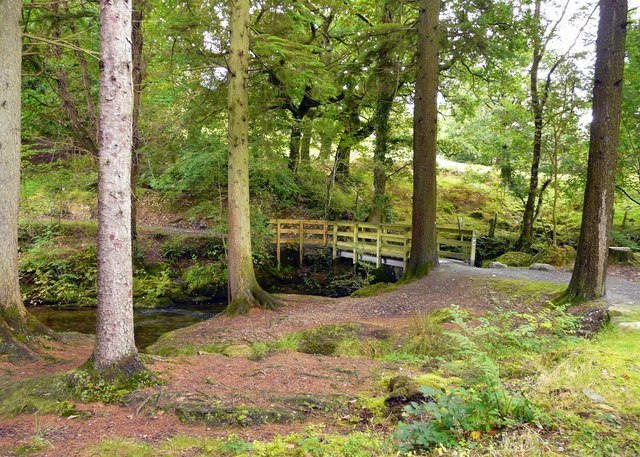 Coed-y-Brenin forest track
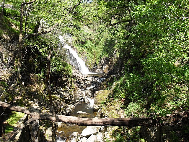
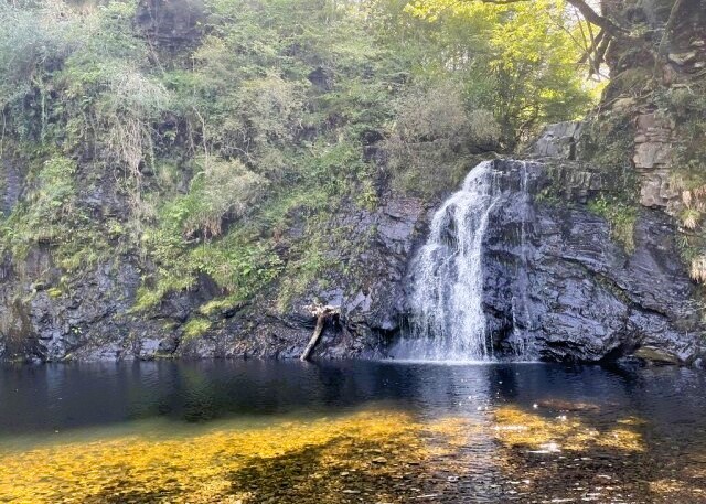 Rhaeadr Du Waterfall
One major incident in this long history happened around 1404. The house was burned down by Owain Glyndwr, supposedly because of the family subjection to Henry V. However, legend tells a more interesting tale. Hywel Sele, the 8th Lord Nannau, had resolved to settle a quarrel with Owain Glyndwr by killing him while out hunting. Hywel pretended to aim an arrow at a deer and at the last moment he turned to fire at Owain. His aim was true, but imagine his horror as the arrow struck, not with the dull thud as expected, but rebounded with a clank. Owain protected by armour under his tunic, turned and without hesitation, slew Hywel. He then hid the body in a hollow tree and went back to the house and burned it. Forty years later, a skeleton was discovered in this tree, and it became known as the 'Demon's Hollow Tree'. Apparently it fell in a great storm which occurred in 1813.
Also dating back to ancient times is the Drover's Road, which follows the river through the forest. Before the railways were introduced in the 19th century, cattle were moved through the forest on their way to the markets in England, after crossing the mountains from Llanbedr. Great herds of up to 400 used to stop in the valley, to be shod in preparation for the long journey. They were penned, brought down with a rope, and then fitted with two shoes on each hoof.
The walk begins at Dolfrwynog and climbs through the forest towards the Mawddach River. As the path descends to the river, you go through an area designated as a nature reserve. On the way you will see the earliest of the original forest with Birch, Oak, Alder, Ash and Willow. However, as these species take around 100 years to reach maturity, it is not surprising that they have become greatly outnumbered by exotic conifers like the Grand Fir, Douglas Fir and Japanese Larch. These can reach maturity within 40 years. In fact, the largest tree in the forest, which you will pass, is a Grand Fir standing 150 feet high which is around 100 years old.
These conifers have thankfully provided refuge for the rare native Red Squirrel, which has been ousted from the natural forest by the Grey Squirrel. Fallow Dear, descended from the herd owned by the Vaughan's are more likely to be spotted. Also found in the forest are Otter, Polecat and Pine Martin.
Birdlife is rich and varied. Goshawk, Goosander, Black Grouse and Peregrine may be seen, while Pied Flycatchers, Wood Warblers and Redstarts are some of the summer migrants. Grey Wagtails, Dippers and Heron fish the rivers.
 Pistyll Cain Waterfall and Afon Gain
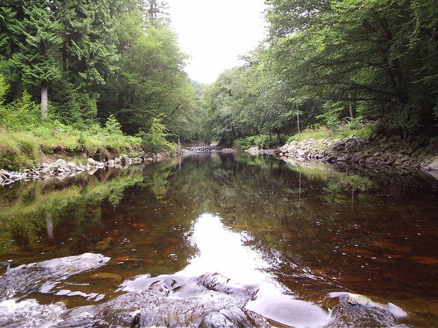 Afon Mawddach
After crossing the Mawddach to Ganllwyd, a short detour to Rhaeadr Du, or Black Waterfalls, can be made. These have been a popular tourist attraction since the 18th century, when rugged nature was in fashion. The artists Gainsborough, Turner and Richard Wilson were attracted to these falls.
The route now follows a forestry trail alongside Afon Mawddach. The river, like the Cain and Gamlan, is a spate river. It can be fished (with permit) and Brown Trout and Minnows are always there. From June to November, Salmon and Sea Trout are making their way to their spawning beds. Spring and early summer also see the river banks clothed with flowers, including Marsh Marigold, Bugle, Globe Flower, Bluebells and Cow Wheat.
As the walk reaches Pistyll Cain some old buildings will be noticed. The most noticeable of these are just below the falls. A leat off the river, just above the falls, once fed a reservoir leading to an iron pipe some 12 inches in diameter. This was to provide power for the gold mines situated about 400 yards upstream.
The central area of the forest is a nature reserve and the walk crosses it and circumnavigates much of the perimeter. Considerable efforts have been made to welcome visitors, and it is well worthwhile calling in at the forest visitor centre. Also four trails for walkers, and new trails for mountain bikers, have been laid out and marked with posts with coloured tops. The route covers part of two of these trails, the nature trail with green topped posts and the waterfalls and gold mines trail with yellow topped posts. However, these trails are well walked, so our route goes to more remote parts of the forest, thus increasing the chances of spotting some of the more timid wildlife.
There are over 100 miles of forest roads and paths to explore. To aid navigation posts have been erected at major junctions. These have an off white coloured top and a number attached. If you buy a park guide this gives you a map of the whole area. On the map, each post is shown with its number and so your position can be pinpointed with ease and accuracy.
Acknowledgment: Text derived from the Out and Out Series; Discovering the Countryside on Foot. Pictures courtesy of Wikipedia.


