Holyhead Mountain, North Stack and South Stack
Along cliffs to a nature reserve, to lighthouses, and a trek over a mountain
Google Maps Open Source Maps| Statistics and Files | ||
|---|---|---|
| Start: Car Park | Distance: 7.6 miles (12.3 km) | Climbing: 520 metres |
| Grid Ref: SH 22563 83285 | Time: 3-4 hours | Rating: Hard |
| GPX Route File | Google Earth File | About Holyhead |
| Statistics | |
|---|---|
| Start: Car Park | Distance: 7.6 miles (12.3 km) |
| Climbing: 520 metres | Grid Ref: SH 22563 83285 |
| Time: 3-4 hours | Rating: Hard |
| GPX Route File | Google Earth File |
Ordnance Survey Explorer Map (1:25,000)
The Walk:
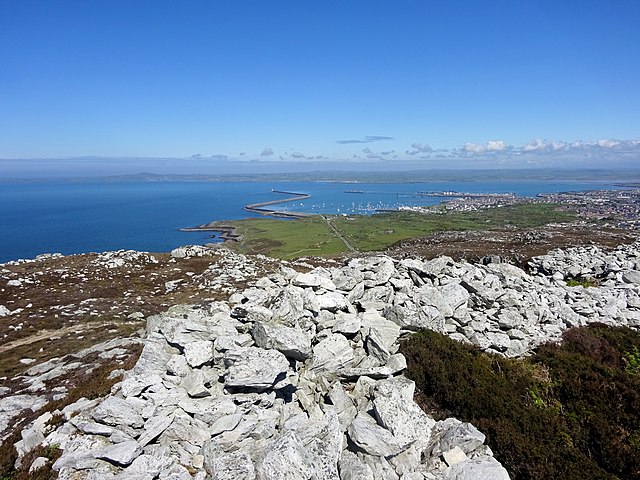
Holyhead Mountain, although a mere 722 feet (220 metres) in height, is the highest point on Anglesey, and, with its sheer rock faces, looks more daunting than it really is. From its summit there is usually a fine view of Holyhead and its great harbour, of the hundreds of yachts at anchor or sailing round the coast, and the comings and goings of the car ferries.
On the very finest days, when the air is crystal clear - usually after rain and rarely in the height of summer - the summit commands views of Ireland's Wicklow Mountains to the west, the Isle of Man to the north, and eastwards over the whole Snowdon range. The mountain is well endowed with archaeological sites, and a network of tortuous tracks and rocky paths, some unsuitable for the inexperienced walker, and all have some very steep sections.
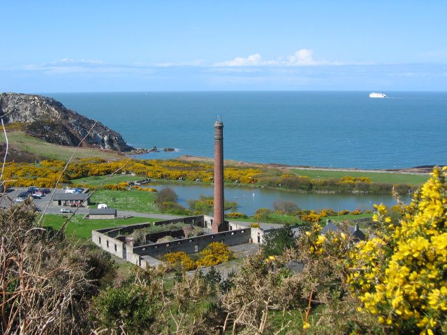 Holyhead Breakwater Country Park
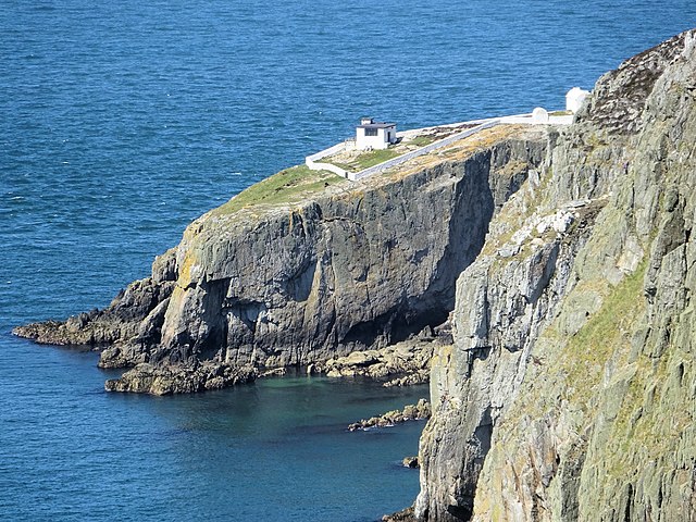 North Stack/ Ynys Arw
The walk starts with a gentle detour round the edge of the low limestone cliffs west of the breakwater to the quarries at the base of the mountain. The quarry site, with its ruined buildings, is now a country park. It was here that limestone was quarried, pulverised and made into house bricks for export from Holyhead.
The walk climbs over the top of the quarries, then takes a switchback route across the heads of several coves to North Stack. The fog signal station near here has a separate magazine, used for keeping the distress flares a safe distance away from the main building. North Stack itself is a 60 foot high rock, separated from the mainland by a 40 foot gully through which the sea often boils.
From North Stack to South Stack, the route goes inland, climbing to the mountain summit and then down again, providing some stiff gradients on rough paths.
On the low slopes of the mountain is Cytiau'r Gwyddelod. This remarkable collection of 20 hut circles is the remains of an extensive settlement occupied from at least 1500 BC to the 3rd century. Many of the walls, although now only about one to two feet tall, complete their circle with door posts. Stone slabs for beds, seats and hearths are still in place.
South Stack is a flat topped pear shaped islet, about 100 feet high and over 300 yards long. The tall white tower of the lighthouse - now unmanned and operated automatically - and the lightkeepers houses are surrounded by white stone walls. The stalk of the island is a chain suspension bridge, which spans the gap between the stack and the cliff face. The 160 steps down the cliff face to the bridge constitutes a small nature trail with observation points. At the top, heath vegetation - gorse, heather and tormentil - holds sway. Further down is the profusion of cliff plants: thrift, scurvy grass, wild thyme, spring squill, English stonecrop, sea campion, kidney vetch, wild carrot, golden samphire, sheep's bit and restharrow.
 Holyhead Mountain/ Mynydd Twr
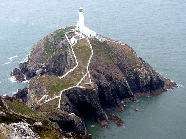 South Stack/ Ynys Lawd
In late May and June, maritime field fleawort blloms here at this, it's only site in the world, and it is followed in June and July by the spotted rock-rose and other rarities. The bare rock face also supports a variety of green and yellow lichens, whose abundance indicates a pollution free atmosphere.
Puffins, razorbills and guillemots breed on South Stack, as do fulmars, which arrived to nest on Anglesey as recently as 1948. In spring and autumn there are a wide variety of songbirds: wheatears, willow and grasshopper warblers, whinchats and ring ouzels among them. Some rare species that have been recorded in recent years include red footed falcon, honeybuzzard, dotterel, hoopoe and bee-eater.
On the return, via the mountain summit, are the vestiges of a 17 acre Iron Age hill fort, Caer y Twr. It takes a practised eye to recognise much of the wall that once encircled the summit, but an entrance gap overlooking Holyhead Harbour is quite obvious. If the wind is not too strong, and the air is clear, allow some time to enjoy the all round panoramas before leaving the gap in the wall for a quick steep walk back down to the start in Holyhead.
Acknowledgment: Text derived from the Out and Out Series; Discovering the Countryside on Foot. Pictures courtesy of Wikipedia.


