Tre'r Ceiri Fort, Porth y Nant and Llithfaen
A hidden village amid spectacular mountain and coastal scenery
Google Maps Open Source Maps| Statistics and Files | ||
|---|---|---|
| Start: Road Side | Distance: 7.2 miles (11.7 km) | Climbing: 570 metres |
| Grid Ref: SH 37867 44176 | Time: 3 hours | Rating: Hard |
| GPX Route File | Google Earth File | Tre'r Ceiri Fort |
| Statistics | |
|---|---|
| Start: Road Side | Distance: 7.2 miles (11.7 km) |
| Climbing: 570 metres | Grid Ref: SH 37867 44176 |
| Time: 3 hours | Rating: Hard |
| GPX Route File | Google Earth File |
Ordnance Survey Explorer Map (1:25,000)
The Walk: This is a fairly long, and sometimes strenuous expedition to a peak nearly 1,600 feet, (488 metres) high, and down a deep ravine to the coast of the Llyn Peninsula, the most Welsh part of Wales. It begins on the roadside, not far from the village of Llanaelhaearn, which has a church founded in the 6th century, and a holy well whose crystal clear eminently drinkable water still forms part of the village system.
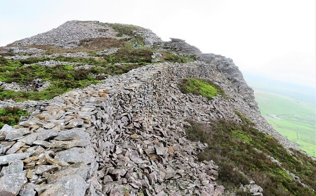 Tre'r Ceiri Fort
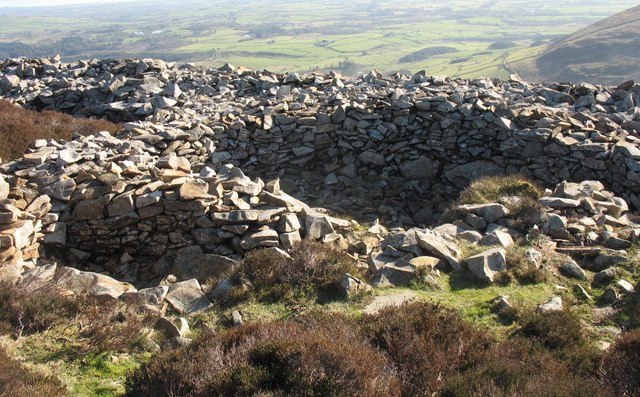 Dwellings in Tre'r Ceiri Fort
You climb a path grassy in parts, but at the steepest part made up very rough ankle jarring loose stone, up the slope to Tre'r Ceiri Fort, the town of the Giants, arguably the most dramatic prehistoric fortification in Britain, and certainly in Wales. It covers nearly five acres and provides some wonderful views over the whole region. Some 100 hut circles, arranged in groups, and each facing into a common courtyard, are surrounded by large dry stone walls. There are traces of a defensive stone parapet and walkway inside the perimeter wall.
Tre'r Ceiri was probably first built in the late Bronze Age by the Goidels (Gaels), and remained occupied throughout the time of the Roman occupation. Time and the weather have reduced much of the stonework to shapeless piles, but given time, if the light is right, a slanted sunlight reveals most the pattern of the huts, and their relationship to one another can be determined.
If the wind is blowing in the valley, it will be howling by the fort, and the walls of many of the circles still provide much needed windbreaks. Life must have been very hardier 2,000 years ago, with a steep walk of 1,000 feet (300 metres) up and down to farm the lower slopes - but perhaps the climate was kind then.
The hill fort occupies the top of the eastern most of three conical peaks known collectively as Yr Eifl, the Fork. The walk continues across country, along the low slopes of the central summit, 1,850 feet (464 metres) high to the deep valley of Nant Gwrtheyrn, known popularly as Vortigern's Ravine.
In a castle here, King Vortigern of south-east England once sought refuge after betraying the British to the Jutes under Hengist and Horta in 499 AD. Nature avenged his people; ortigern burned to death in his castle after it was struck by lightning. Given that Welsh was the language of the British who found their final refuge from successive waves of invaders from the east in what is now Wales, it is appropriate that the site of the King's Castle is now occupied by a thriving National Language Centre.
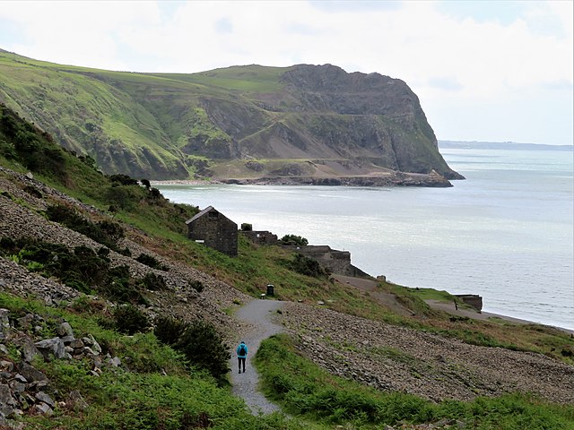 Porth y Nant and Penrhyn Glas
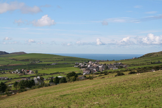 Llithfaen and Porth y Nant
For centuries, a community of farmers scraped a living off the small patches of fertile land on the slopes of the ravine. With the coming of the Industrial Revolution, some faces of Yr Eifl were quarried for granite, and a model village, Porth y Nant, was built in 1863 on a grassy ledge by the sea to house the workforce. The village was completely self contained with a chapel, a school, a village green and a grand house for the quarry manager.
The granite was shipped out from a quay, and most of the villages supplies also had to be brought in from the sea, as the only other access was down a rocky, rutted path, dropping some 800 feet (240 metres) on a steep gradient, and impassable to any vehicle more complex than a horse drawn sled.
Today, the village is beautifully restored and q metalled road with breathtaking gradients and hairpins has been engineered to service the Nant Gwrtheyrn National Language Centre, which has a cafe for students and visitors. The treacherously steep and slippery original track, however, is still open and passable with care for those who wish to get an idea of the harshness of life here as it was in previous centuries.
From Porth y Nant, the route takes you along a well-marked cliff top route past Gallt y Bwlch, an ancient wood of stunted sessile oaks, birch trees and wood sage. The area has been designated a Site of Special Scientific Interest and the cliffs which rise some 300 feet (90 metres) above the sea are a nesting site for thousands of seabirds.
The route back takes you along the quiet B4417 road which includes a walk through the lovely village of Llithfaen. From the village you can realx and enjoy the views provided by this wonderful quiet corner of north-west Wales.
Acknowledgment: Text derived from the Out and Out Series; Discovering the Countryside on Foot. Pictures courtesy of Wikipedia.


