Manobier, King's Quoit, Priest's Nose and Manobier Castle
Explore a distinctive coastline from a castle near the sea
Google Maps Open Source Maps| Statistics and Files | ||
|---|---|---|
| Start: Manobier | Distance: 2.9 miles (4.7 km) | Climbing: 160 metres |
| Grid Ref: SS 06419 97760 | Time: 1-2 hours | Rating: Easy |
| GPX Route File | Google Earth File | About Manobier |
| Statistics | |
|---|---|
| Start: Manobier | Distance: 2.9 miles (4.7 km) |
| Climbing: 160 metres | Grid Ref: SS 06419 97760 |
| Time: 1-2 hours | Rating: Easy |
| GPX Route File | Google Earth File |
Ordnance Survey Explorer Map (1:25,000)
The Walk: Manobier lies in a delightful quiet vale overlooking a curved sandy bear on the southern coast of Dyfed. The castle and village attract thousands of visitors every year, but nonetheless, it somehow manages to retain the timeless atmosphere of an unspoiled place. The valley is bordered by hilly farmland on three sides, while on stormy days, the sound of surf pounding the beach and cliffs can be heard in the village. And sand is blown up the valley, collecting near the base of the castle.
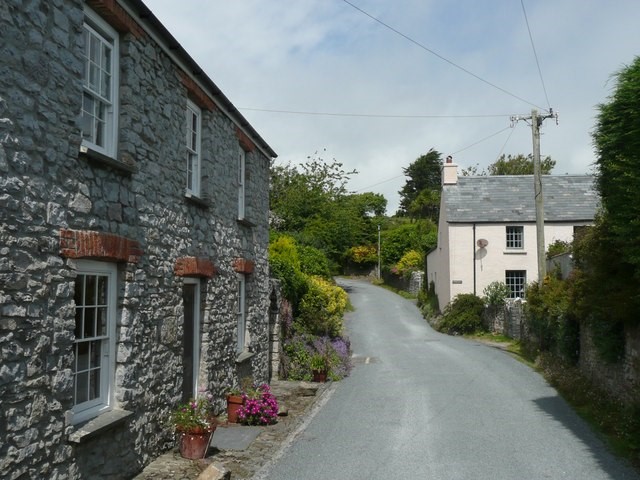 Manobier village
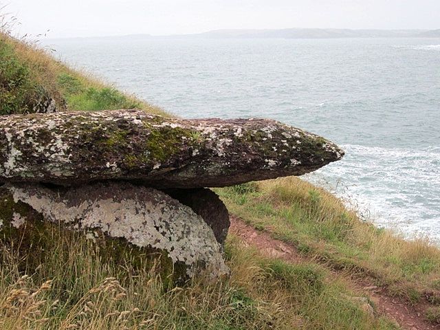 King's Quoit Neolithic Tomb
In the 12th century, ships sailed the short distance from the present shoreline right up to the castles water gate. This and other details of the lives of Norman and Welsh Lords of Manobier are apparent from the writings of a man who was born near 1146. Giraldus Cambrensis (Gerald of Wales), who became one of the foremost scholars of his day.
At the time of the Norman Conquest, this was known as the Manor of Pyr, named after the Abbot of nearby Caldey Island. William I awarded it to the de Barri family for their military services in subduing the Welsh. In the next 250 years, under their ownership, Manobier was transformed from a monastic grange where monks worked the land, to a fortress-cum-farm. They provisioned garrisons at larger castles nearby.
Manobier was never attacked, and the de Barri fish ponds, mills and dovecote continued to form part of a working farm until the 17th century. Even in ruins, the castle continued to be an agricultural centre.
The dovecote building exists to this day. This cylindrical stone building has about 250 pigeon holes, enough to provide the lodge table with up to 6,000 squabs, the unfledged birds that were prized as the most succulent. Pigeons were an important source of fresh winter meat in the Middle Ages. Only landowners were allowed to keep them. They ranged free, and it was a crime to kill or catch them.
What the rich did about loss of pigeons to raptors is unknown. In Gerald's day, the peregrines of Pembrokeshire were among the most prized of falcons, and he describes how they were used to kill the herons that came to prey on the contents of the fish ponds.
Writers other than Gerald have found their inspiration here. At the turn of the century, George Bernard Shaw spent several months at Manobier taking the airs and writing a successful West End play, 'Captain Brassbounds Conversion'.
At about the same time, Virginia Steven, later Virginia Woolf, was a regular summer visitor with her family. She confided to her diary how walking along the coast inspired her so that all she wanted to do was write, write, write. And how she sat on the sand drawing up the courage to tell her parents of the career she had chosen.
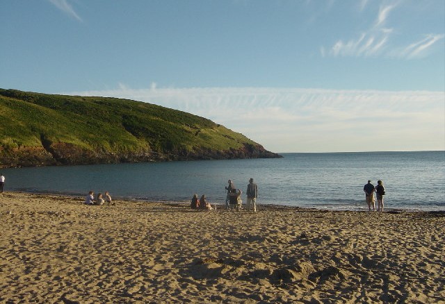 Manobier Bay
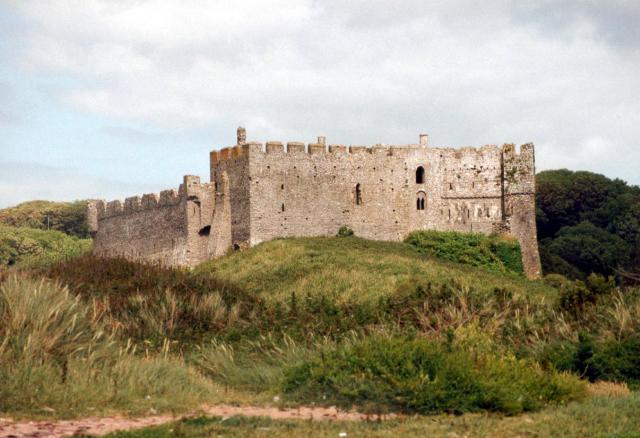 Manobier Castle
Today, the beach provides inspiration for surfers who come from miles around. Undersea rock formations force up a steady supply of large waves. The route leaves the castle and beach behind for the Pembrokeshire Coast Path, which leads to the quaintly named headland, the Priest's Nose. The outline of the rocks is said to resemble the imposing profile of the Archdeacon de Barri, but as no picture of him exists, the story is probably fanciful.
A gentle slope leads up to the half covered remains of King's Quoit, a Neolithic burial chamber that dates from around 3000 BC, and was fashioned from the local fossil encrusted red standstone. Its huge capstone rivals any other in Wales for size, but since this cromlech is partly covered by earth, as they all were originally, it cannot compete as the most spectacular.
The coast path comes into its own beyond the cromlech, with views far and wide across Carmarthen Bay and the Bristol Channel. Long fault lines cut the rocky coast into dangerous but fascinating crevices, some up to 100 feet (30 metres) deep.
Heather, gorse and bracken grow in abundance along with sea pinks, kale, ox-eye daisies, and very unusually in this type of habitat, snakes head fritillaries. Cormorants, shags and gulls sail past you at eye level. Eventually you arrive at a cliff overlooking an enticing sandy bay. The scramble down is worth it for those who like to swim. The sea here is calmer than at Manobier, and there is less danger of being hit by a surfboard.
The route heads inland from here. Before following it, take some time to admire the striking cliffs of Old Castle Head, above the beach to the east. There is a Celtic hill fort dating from 300 BC on the headland. It's builders skillfully included the abrupt changes in ground level, as well as geological faults, when they fortified the site. The headland has formed part of a Royal Artillery range for many years and access is very strictly controlled.
The return to Manobier is along a well signposted footpath, and quiet country lanes through open country, then along a minor road. There are memorable views of the church, castle and village for a good part of the way after you pass Hill Farm.
Back in the village, a short climb leads to St James, the Norman church on the hill across from the castle. The church is entered down stairs through a vaulted porch, in which there are remains of a medieval painting. Inside there are stone effigies of various lords of the manor, one of whom died on the crusade to the Holy Land.
Acknowledgment: Text derived from the Out and Out Series; Discovering the Countryside on Foot. Pictures courtesy of Wikipedia.


