Port Eynon, Culver Hole, Wales Coast Path and Paviland Manor
A smuggling village and ancient caves on the rocky Gower coast
Google Maps Open Source Maps| Statistics and Files | ||
|---|---|---|
| Start: Port Eynon | Distance: 5.9 miles (9.5 km) | Climbing: 186 metres |
| Grid Ref: SS 46735 85158 | Time: 3 hours | Rating: Moderate |
| GPX Route File | Google Earth File | About Port Eynon |
| Statistics | |
|---|---|
| Start: Port Eynon | Distance: 5.9 miles (9.5 km) |
| Climbing: 186 metres | Grid Ref: SS 46735 85158 |
| Time: 3 hours | Rating: Moderate |
| GPX Route File | Google Earth File |
Ordnance Survey Explorer Map (1:25,000)
The Walk: This walk takes in a curved sandy beach and a rocky inlet, an old fishing village with a smuggling past, intriguing architectural remains, caves once inhabited by prehistoric people and animals, and clifftop farmland.
 Port Eynon Point
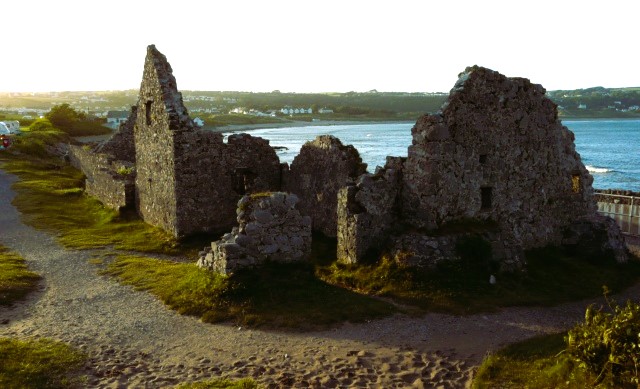 Port Eynon Salt House
The route starts from a village with a salty past. Port-Eynon, on the southern tip of the Gower Peninsula, was named after an 11th century Welsh Prince who built a castle here. No trace of it now remains. Despite the growing demands of recreation and tourism, this seaside village returns much of its ancient character with narrow lanes and a Norman church.
The village was once a haven for a rough breed of seaborne adventurers. And in the late 18th century, when smuggling was in its heyday, up to eight Customs and Excise men had to be stationed in the village.
To the south of the village is the Salt House, which consists of the remains of several fishermen's cottages. Visible today are the foundations of two that were occupied until the 1860's. Salt for curing fish was made there by evaporating sea water. The sea reaches the old walls at high water and at low tide, the remains of other structures are visible, including stone vaults that once formed a quay. The original Salt House was a fortified mansion belonging to John Lucas, a 16th century adventurer.
Further south along the rocky shore, Port-Eynon Point offers a good view back to the curved beach, and westwards along the coast. Below the point lie two ridges of sand and rock that can be approached from the shore, but are cut off by spring tides. The easiest to get to is Sedger's Bank while Skysea lies further from the shore.
A cave lies at the tip of Port-Eynon Point. It can be reached at low tide via track along the shore from the Salt House. Prehistoric bones have been found inside the cave, but this site does not really compare with other caves further along the walk.
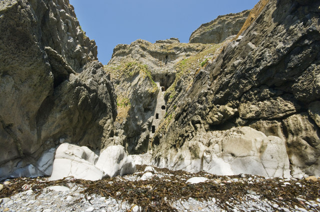
Around the headland are Overton Mere and Culver Hole, the focus of many local legends. The hole's outer wall of masonry, built in the narrow cleft between two cliffs that fall sleepily to the sea and pierced with windows, stands 60 feet (18 metres) high. It is almost impossible to scale without using ladders or climbing gear. Inside there are some stone shelves along the walls. These niches may have been nesting holes for pigeons. Some people think this intriguing structure was a dovecote for the now vanished Port-Eynon Castle, since a similar structure has survived at nearby Oxwich Castle. Others maintain that Culver Hole was a smuggler's den.
Yet another theory suggests that it was a Celtic hermit's retreat dating from the 16th century. John Lucas of the Salt House was reported to have rebuilt 'Kulverd Hall' in the sixth century and used it as a stronghold. This has given rise to the fanciful legend of a secret passageway leading to the Salt House through the limestone cliffs.
 Culver Hole
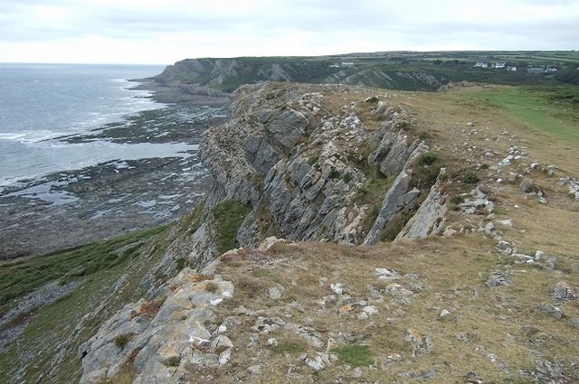 Wales Coast Path at Overton Cliff
From above Overton Mere, the cliff-top path leads westwards towards three of the most interesting caves in Glamorgan. Longhole Cave on Overton Cliff is about 130 feet (39 metres) above the high watermark, and is reached by a footpath branching off the main track. Animal remains and prehistoric artefacts have been discovered here by archaeologists. Many are now in the British Museum and the National Museum of Wales.
Paviland Caves lie lower down the cliffs near Foxhole Slade. These are difficult to find, and extremely dangerous to approach, due to incoming tides and crumbling cliff paths. The larger cave, Goat' Hole has yielded some of the richest finds in Britain for archaeologists. A headless skeleton stained red, and named the Red Lady of Paviland, was unearthed from its floor in 1823, and by 1913 over 800 implements, along with many Ice Age animal bones, had been discovered.
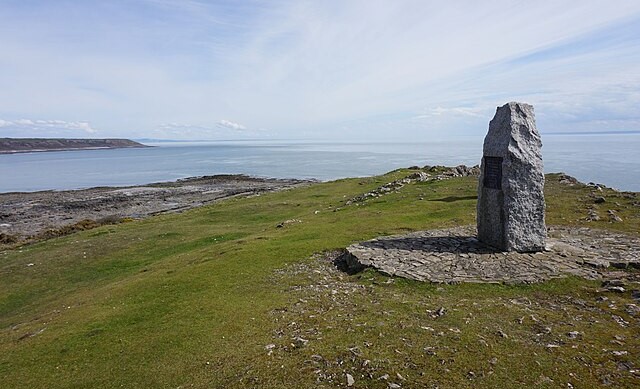
The route back to Port-Eynon follows well trodden footpaths and quiet byways inland across beautiful farmland. The trig point near Hills Farm offers a fabulous panorama of the South Gower headland on a fine day. From here there is an easy descent to Port-Eynon Village.
Acknowledgment: Text derived from the Out and Out Series; Discovering the Countryside on Foot. Pictures courtesy of Wikipedia.


