Carreg Cennan Castle, Llygad Llwchwr and Garreg Las Hut Circles
Explore the limestone landscape around a great natural fortress
Google Maps Open Source Maps| Statistics and Files | ||
|---|---|---|
| Start: Carreg Cennan | Distance: 5.3 miles (8.6 km) | Climbing: 359 metres |
| Grid Ref: SN 66641 19352 | Time: 3 hours | Rating: Hard |
| GPX Route File | Google Earth File | Carreg Cennan Castle |
| Statistics | |
|---|---|
| Start: Carreg Cennan | Distance: 5.3 miles (8.6 km) |
| Climbing: 359 metres | Grid Ref: SN 66641 19352 |
| Time: 3 hours | Rating: Hard |
| GPX Route File | Google Earth File |
Ordnance Survey Explorer Map (1:25,000)
186 Llandeilo and Brechfa Forest/ Fforest Brechfa
The Walk: Perched on sheer limestone cliffs, the brooding ruins of Carreg Cennen Castle cast a foreboding shadow over the peaceful Cennen Valley. It is a site redolant of history in a landscape of wild grandeur.
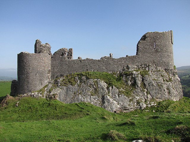 Carreg Cennan Castle
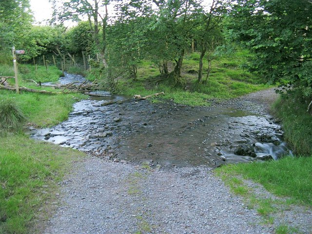 Ford near Llygad Llwchwr
This walk begins by heading across the land south of the massive rock of Carreg Cennen, whose impressive bulk dominates the skyline throughout. Three of its sides are 300 foot (91 metre) precipices, natural defences that have historically made the site attractive to settlers.
You walk down into a valley by hedgerows with a colourful profusion of lords and ladies, dog violets, stitchwort, wood sorrel, celandine and yellow rattle. The area is a nature reserve and is rich in bird life. Pied flycatchers, redstarts, wood warblers, woodpeckers, tree creepers and nuthatches are all found here.
The track follows the stream past the source of the Llwchwr, or Loughor. The river issues rather unromantically from a waterboard regulation point, though the banks on either side are carpeted with spotted orchids in late spring. Around 17 miles of underground passages lead from the Llygad Llwchwr cave which is a hotspot for cavers.
Nearby are the remains of 19th century limekilns, where rock was processed to reduce the acidity of the peaty soils and the surrounding uplands. In the deep, tree lined ravines along the path are the entrances to badger setts, piled high with soil and old bedding. Well worn badger highways cross the shady woodland floor.
The path runs along the lower slopes of the Black Mountain about 1,000 feet (300 metres) above sea level, with views back across the valley at Beddau'r Derwyddon are long low grassed over mounds known as 'Druid's Graves'. They are medieval pillow mounds, man-made warrens constructed where the soil was too thin for rabbits to burrow.
At the highest point of the walk at Garreg Las are the remains of Iron Age hut circles. ou will find evidence of ancient sites such as these all over the Black Mountain, which were probably communal meeting sites for the pre-historic hunter gatherers and early settlers of this remote and wild landscape.
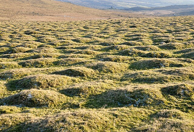 Pillow mounds at Beddau'r Derwyddon
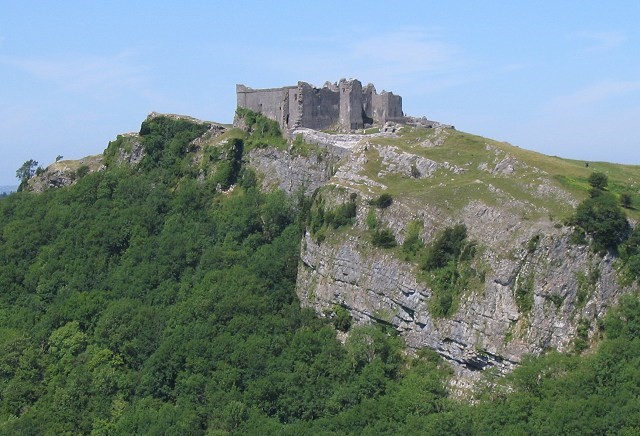 Carreg Cennan Castle, as seen from the hills
The open woodland and moor on the return to Carreg Cennen is the haunt of short-eared owls, ravens and kestrels. Buzzard circle over the tree tops with wings outstretched on the lookout for rabbits, voles and carrion. The occasional red kite may also be seen circling high on the rising thermals over the remote uplands.
The first Carreg Cennen Castle was probably built by the Welsh Chieftain, Prince Rhys ap Gruffydd, near the end of the 12th century. It was taken without a fight by Edward I in 1277. Most of what is visible today dates from the English occupation, which lasted well over a century. Some chroniclers say the castle fell to Owain Glyndwr early in the 15th century; others say the garrison's national defence being so good - that less than 20 men could defend it - held out until the rebellion ended in 1410.
The castle was a Lancastrain stronghold in the Wars of the Roses, but was surrendered in 1462. Soon afterwards, 500 men with picks and crowbars spent 110 days ruining the castle so that it could no longer be used. There is enough left, though, to give an indication of its layout and some spectacular viewpoints.
The castle has its own water supply, in a cave in the rock beneath. This is reached via a 200 foot (60 metre) vaulted passage, made by covering over a path down the rock face. The passage is dimly lit by narrow slits in the outer wall, but thus wishing to explore should take a torch or wrist bump in their heads.
Stewardship of the ruins passed back and forth between Welsh and English noble families until the 1960s when it was accidentally included in the sale of some agricultural land. It now belongs to Castle Farm in the valley below, where the walk ends. The site is managed by Cadw.
Acknowledgment: Text derived from the Out and Out Series; Discovering the Countryside on Foot. Pictures courtesy of Wikipedia.


