Rowen, Caer Bach Fort, Maen Penddu and Llangelynin Old Church
To an ancient church high in the mountains above Conwy
Google Maps Open Source Maps| Statistics and Files | ||
|---|---|---|
| Start: Rowen | Distance: 6.2 miles (10.1 km) | Climbing: 455 metres |
| Grid Ref: SH 76052 71939 | Time: 3 hours | Rating: Moderate |
| GPX Route File | Google Earth File | About Rowen |
| Statistics | |
|---|---|
| Start: Rowen | Distance: 6.2 miles (10.1 km) |
| Climbing: 455 metres | Grid Ref: SH 76052 71939 |
| Time: 3 hours | Rating: Moderate |
| GPX Route File | Google Earth File |
Ordnance Survey Explorer Map (1:25,000)
The Walk: As the winding lane to Rowen leads the motorists nowhere further, the village is usually found by accident. Once there, it is tempting to linger, especially on one of the wooden benches beside the river opposite the Ty Gwyn pub. It is a picture postcard village of white stone cottages and flower filled gardens. Through it runs the Afon Roe, which rises among the peaks and ridges that tower 2,000 feet (600 metres) above the village.
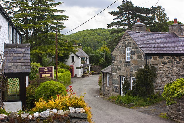 Rowen villlage
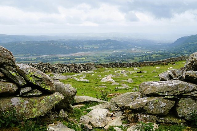 View from Caer Bach Fort to Conwy Bay
Branching off the lane is an old Roman road, which rises steeply up the mountainside and heads through a high pass. At its far end is Aber, on the Lavan Sands, where man and horse made the perilous crossing to Anglesey before a bridge was built across the Menai Strait. The walk starts with a steady climb up this road, metalled for a while and then quite rough, to Maen-y-bardd (the Poet's Stone), a burial chamber at about 1,100 feet (335 metres). On the way along the roads you also pass Rowen Youth Hostel.
From the cromlech you can see right out over the Conwy Valley, a view which gets wider and more wonderful as the route climbs. A short distance on from Maen-y-bardd is a single standing stone, eight feet high, known as 'Arthur's Spear' (Ffon-y-Cawr). This Arthur was not the legendary king, but a giant shepherd who was said to have thrown his stick towards his presumably equally large dog. Supposedly the stick turned to stone on hitting the ground.
The route leaves the Roman road at Cae Coch for a mountain track, which climbs back parallel with the Afon Conwy under the long Ridge of Tal-y-Fan. Along the way are many heaps and circles of stone, almost certainly the remains of ancient man-made structures. On all the mountain summits parallel with the Conwy Valley are prehistoric hill forts. Indeed you pass one around here; Caer Bach Fort, which translates as 'little fortress'.
From Caer Bach Fort, the track leads to an impressive single standing stone. Maen Penddu stands 6 feet high and measures 3 feet and 6 inches across. From Maen Penddu the route turns from northwards to eastwards, leading to farmstead of Garnedd-wen, at 950 feet (290 metres) above sea level. This is one of the highest farms in Wales, and has a commanding view of the great walls and castle of Conwy, beside the wide estuary.
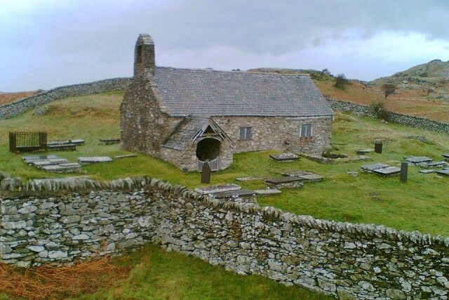 Llangelynin Old Church
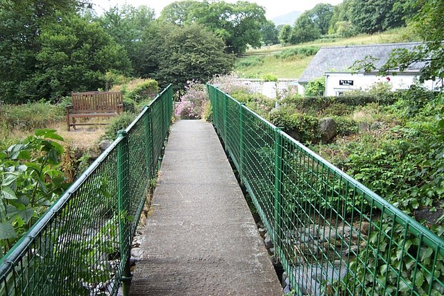 Afon Roe footbridge in Rowen
From Wales highest farm the route continues eastwards to arrive at Wales highest church. Llangelynin Old Church was founded by St Celynin in the 7th century. It has a primitive dignity. The nave was built in the 11th century, and the porch, transept, wooden barrel roof and part of an oak screen in the 14th century. Until the end of the 19th century, only women worshipped in the twelve foot wide nave, while their menfolk kept to the raised north transept, or Capel-y-Meibion (Men's Chapel), which still has its original earth floor.
Ffynnon Gelynin, a holy well in a corner of the graveyard, has been credited with miraculous healing powers. Even today, these are attested to by some locals, who will produce new paper cuttings in evidence. Outside the churchyard are sections of two walls that once belonged to an ale house, used by the slate workers from quarries further up the mountain. Before that, the building was to house the sick as they waited for the healing powers of the holy waters to take effect.
The church sits on an old drovers road, which runs steeply downhill between high dry stone walls, and provides a quick return to the valley. The surface is now too broken up to be passable, even by a Land Rover; but sheep are sometimes driven up it, albeit slowly; the gradient is steeper than 1 in 4.
After a while, the road plunges into a dark tunnel of trees, part of the ancient forest of Parc Mawr, some of which is now managed. The road becomes no more than the twisting track, soft and slippery with fallen leaves, but pleasantly cool for the summer walker. Finally, you follow a country lane back to Rowan. entering the village via a footbridge spanning the Afon Roe.
Acknowledgment: Text derived from the Out and Out Series; Discovering the Countryside on Foot. Pictures courtesy of Wikipedia.


