Tretower Castle, Pen-y-Gaer Roman Fort, Cefn Moel, Felindre and Cwmdu
Country lanes and airy moorland tracks near a Norman castle
Google Maps Open Source Maps| Statistics and Files | ||
|---|---|---|
| Start: Tretower | Distance: 8.1 miles (13.0 km) | Climbing: 382 metres |
| Grid Ref: SO 18646 21286 | Time: 3-4 hours | Rating: Moderate |
| GPX Route File | Google Earth File | About Tretower |
| Statistics | |
|---|---|
| Start: Tretower | Distance: 8.1 miles (13.0 km) |
| Climbing: 382 metres | Grid Ref: SO 18646 21286 |
| Time: 3-4 hours | Rating: Moderate |
| GPX Route File | Google Earth File |
Ordnance Survey Explorer Map (1:25,000)
The Walk: The small village of Tretower has an interesting mix of buildings. The most impressive of them is Tretower Court, where this walk begins. In addition, there is a rather grand farmhouse, the windows of which have hexagonal panes, along with a selection of houses in the dark reddish brown local stone, though some of these have been given a smooth stucco finish.
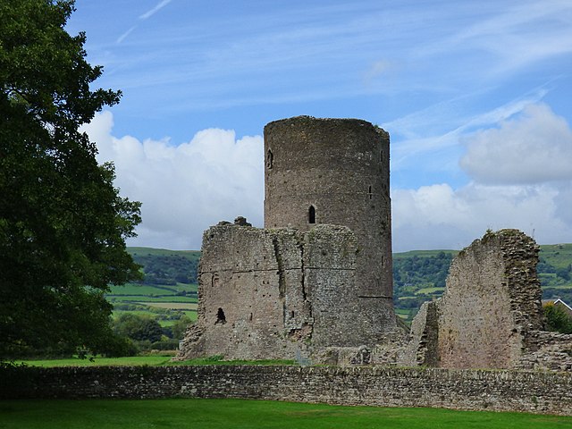 Tretower Castle
 Pen-y-Gaer Roman Fort
As the route leaves to Tretower Court, the tower of Tretower's Norman castle rears up from the fields to the left. At the end of a short section of road, is a small chapel, with an inscription stating that it was erected by Zoar in 1844. It has since been converted into an unusual but handsome dwelling.
The walk leaves the road for a broad farm track across the fields that crowd the broad, flat, valley floor. The hills rising up on every side seemed to consist of a series of ledges, as the smooth curve is broken by escarpments.
A concrete slab bridge takes you across a little river, the Rhiangoll, to a path beside a tall hedge. Here the fields are a mixture of crops and pasture, and this part of the walk is very easy going, with ever changing views down the valleys that open out on either side.
You cross a little flagstone bridge and continue, down the green lane between ferny banks that rise above head height to a trio of farms - Lower, Middle and Upper Gaer. There is an interesting array of farm buildings, some of them converted for housing, while a barn at Middle Gaer has unusual pointed arches, and signs of a former chimney, suggesting it was once a house.
The road leaves past the farm of Pen-y-gaer, which is enclosed by a grassy bank visible on both sides of the road. This square earthwork was part of a small Roman fort. The artificial platform is most clearly seen beyond the farmhouse.
This short section of road walking ends at the next junction, where the path leads uphill through an avenue of gnarled trees. There are some impressive beech trees, but the grandest are the massive oaks, with their short sturdy trunks and wide-spreading branches.
The going gets rougher, with stone pushing up through the soil. The path is clearly an old route; there are remains of stone walls on the banks. It is easier to walk on the grass at the side of the track than on the gully-like path. This has the added advantage of giving fine views across the hills on the left.
You meet a roadway by a group of imposing stone houses. The hillside steepens and a small stream burbles through the rocks to one side of the path, which is still overshadowed by small trees. A track with great slabs of standstone underfoot leads to a point where a splendid panorama opens out.
To the east is the shapely outline of the Sugar Loaf Mountain, above Abergavenny, and the rounded hump of the Blorenge, lying further south on the opposite side of the Usk Valley. From here, the wooded hill above Tretower appears as an isolated hump, and the view stretches over it to the next valley.
The broad track climbed steadily to the ridge of Cefn Moel, at a height of nearly 1,200 feet (366 metres) above sea level. On the top, the bracken is broken by patches of gorse and rough grass, and a dry stone wall snakes along the crest of the ridge.
The hills are far from deserted; wild ponies graze among the sheep, and the air is loud with birdsong - from the harsh chatter of the stonechat and the wheatear, to the tuneful trill of the skylark and the distant mew of a hunting buzzard.
There are signs of man's presence in the remains of small quarries, a cairn and, on the horizon, the ruler-straight edge of a forestry plantation. At a break in the high stone wall, there is a view over to the other side of the ridge. Down below is Llangorse Lake, busy with sailing boats in summer, and beyond that is the great mass of the Brecon Beacons. Here at the top of the hill, the few trees are bent almost horizontal by the prevailing winds.
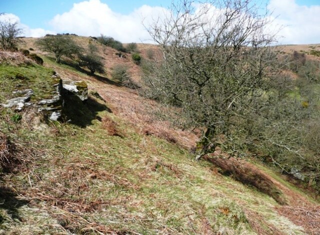 Cefn Moel
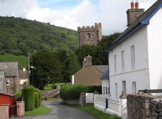 The village of Cwmdu
Just beyond the viewpoint is a rounded grassy hill with a small cairn of stones, and nearby is a crescent shaped overgrown mound of stones. In the Iron Age, water for cooking was heated by throwing in hot stones from a fire. As they broke they were removed, and piled up to create a burnt mound, like this one.
You descend gently, then turn off to the right on a narrow, grassy path through the bracken, which heads steeply down into a deep valley, its sides studded with scrubby trees. A stream, the Clarach Brook, tumbles down to a small farmhouse sitting at the edge of the valley, surrounded by a noisy clutter of sheep, goats, dogs and chickens. With its whitewashed walls and grey slate roof, it is the epitome of a hill farm.
The route continues along the farm track beside the stream to a second larger farmhouse, with neat dormer windows. Beyond it, you join a country lane that runs between high beech hedges. In this enclosed world, the banks on either side are bright with flowers, whose heavy scent seems to be trapped in the deep lane.
As the road runs into a little wood, it begins to drop quite steeply with tall ferns on one side and dense coppiced woodland on the other. To the left is a steep hillside covered with trees. The loop runs round this hill, which is revealed as a long promontory. Its steep sides made it an ideal natural defensive position and Iron Age settlers built a rampart and ditch across its neck to create a small ford, Coed y Gaer.
An old two-arched stone bridge crosses the river, which tumbles over a low weir at the edge of the village of Cwmdu. A mill once stood at the site. The houses are a mixture of old and new, some whitewashed, some left as dull, brownish red sandstone.
The road crosses a single arched bridge to come to the village pub, opposite which on a slight rise, stands the parish church of Michael the Archangel. The churches most prominent feature is its sturdy crenellated tower, but there is an interesting detail on the buttress between the two porches. An ancient gravestone has been left in the wall and its inscription reads 'Here lies Catloc the son of Teyrnoc' in Celtic script. It was brought here by the Reverend T Lewis in the last century.
The final part of the route runs past a large, but well screened caravan park, then continues along a footpath and old road between Cwmdu and Tretower. Once again, grand old oak trees line and overshadow the route. In several places, the path is a narrow green corridor, and at one point plunges into a little rocky gully. It runs down to the main road that leads back into Tretower.
Acknowledgment: Text derived from the Out and Out Series; Discovering the Countryside on Foot. Pictures courtesy of Wikipedia.


