Penarth, Lavernock Point and Cosmeston Lakes
A Victorian resort, and a country park with an unexpected attraction
Google Maps Open Source Maps| Statistics and Files | ||
|---|---|---|
| Start: Penarth Pier | Distance: 5.3 miles (8.6 km) | Climbing: 116 metres |
| Grid Ref: ST 18933 71337 | Time: 2-3 hours | Rating: Easy |
| GPX Route File | Google Earth File | About Penarth |
| Statistics | |
|---|---|
| Start: Penarth Pier | Distance: 5.3 miles (8.6 km) |
| Climbing: 116 metres | Grid Ref: ST 18933 71337 |
| Time: 2-3 hours | Rating: Easy |
| GPX Route File | Google Earth File |
Ordnance Survey Explorer Map (1:25,000)
The Walk: Penarth grew up around a tiny church on the headland overlooking Cardiff Bay. In the 19th century, the medieval St Augustines was replaced by a much grander church, designed by the architect William Butterfield. A fashionable town, home to several ship and mine owners, developed on the headland, while a genteel seaside resort grew up southwards along the coast.
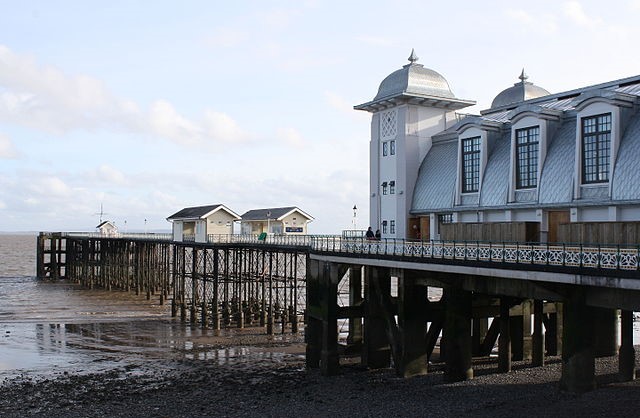 Penarth Pier
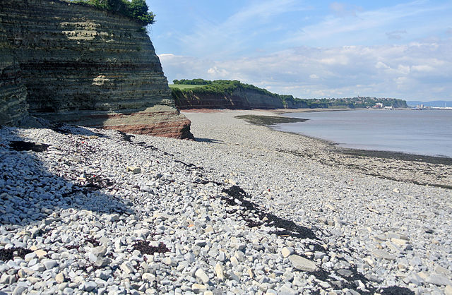 Lavernock Point
A pier was built in Penarth in 1894, and a regular steamship service was established between Clevedon in Somerset and the town. The pier was used for steamship sailings, including the Waverley, the last seagoing paddle steamer in the world, which still operates around the British coast. Penarth Pier also provides the starting point for the walk, which soon climbs the hill behind the Esplanade into Windsor Gardens. This. strip of lawns and shrubbery, complete with bandstand, was laid out in 1884 and retains an air of quiet gentility.
A cliff top path running first through wide lawns, and then along a gravel track between hedges and fields, gives fine views across the Severn Estuary; beyond the islands of Flat Holm and Steep Holm are Clevedon, Sand Bay and Brean Down, with the Mendips rising behind. Further south, are Brent Knoll and the Quantocks.
The coastal path ends somewhat abruptly at Lavernock. If the tide allows, you may like to go down to the beach and scramble across the stones to Lavernock Point. From the pavement of limestone beneath the cliffs, there are splendid views across the Bristol Channel to Exmoor.
Lavernock today consists of a few ruined farm buildings, and a small church. In the farm, on 11th of May 1897, Guglielmo Marconi received the first radio message ever transmitted across water, when his colleague on Flat Holm prosaically asked "Are you ready?". A plaque on the churchyard wall commemorates this event.
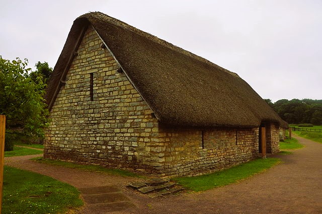 A building in Cosmeston Medieval Village
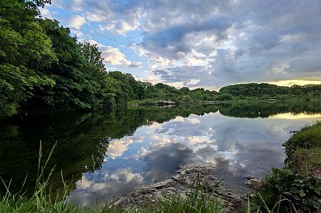 One of the Cosmeston Lakes
A lane leads past the chalets of Lavernock Point Holiday Estate to Cosmestone. This is the site of a village deserted in the 14th century, and rediscovered only in 1982. Excavations were made, and the village has now been reconstructed on the original foundations using medieval tools, methods and materials. The village is now a museum, appropraitely named the Cosmestone Medieval Village, and it is open to the public.
The village is within the boundaries of Cosmeston Lakes Country Park, created on the site of some limestone quarries. The route leads along an old lane between the lakes; the one on the right is used for windsurfing and sailing, while that on the left is a conservation area. Its islands of reeds and sedges provides nesting places for water birds.
The route goes around the pleasure lake and past the visitor centre, which has displays on the parks wildlife, and provides guided tours of the medieval village.
At the main entrance, you crossed the main Penarth to Sully road, into a modern housing estate built on the site of an old lime works. A road leads gently uphill to what was once a railway branch line, and is now a footpath leading back into Penarth, through the extensive modern development south of the town.
The walk ends with a stroll along the seafront, back to the pier. On the way, you pass the ornate Victorian iron verandahs of the Yacht Club, and the formal Italian Gardens, which were laid out in 1926.
Acknowledgment: Text derived from the Out and Out Series; Discovering the Countryside on Foot. Pictures courtesy of Wikipedia.


