West Stow Country Park, Larkford Lakes, Brockley Corner and Culford
A nature reserve and ancient settlement on the edge of Breckland
Google Maps Open Source Maps| Statistics and Files | ||
|---|---|---|
| Start: West Stow | Distance: 8.2 miles (13.2 km) | Climbing: 69 metres |
| Grid Ref: TL 82017 70464 | Time: 3-4 hours | Rating: Moderate |
| GPX Route File | Google Earth File | About West Stow |
| Statistics | |
|---|---|
| Start: West Stow | Distance: 8.2 miles (13.2 km) |
| Climbing: 69 metres | Grid Ref: TL 82017 70464 |
| Time: 3-4 hours | Rating: Moderate |
| GPX Route File | Google Earth File |
Ordnance Survey Explorer Map (1:25,000)
The Walk:
East Anglia's Breckland, straddling Norfolk and Suffolk, has a distinctive character shaped by geography and history. During the last Ice Age, the area - essentially a wide chalk basin - was spread with glacial deposits, which were. subsequently broken down and washed away, leaving behind a shallow surface layer of fine sand. As these loose light soils supported only a sparse covering of trees, they were easily cleared and cultivated.
This encouraged settlement and, by neolithic times, Breckland had become one of Britain's most densely populated regions. But because the thin sour sands were soon exhausted, a system of shifting cultivation developed, and at the same time livestock became more important than arable farming. Fields were cropped for just a few years, then abandoned and new areas cleared. Gradually Breckland was transformed into a vast heath given over to grazing.
From Roman times onwards, sheep assured Breckland's prosperity and during the Middle Ages played a vital role in East Anglia's thriving wool industry. In the 13th century, the sheep were joined by rabbits. Introduced from France, they were farmed in warrens for fur and meat - but many escaped. Towards the end of the Middle Ages, the area's fortunes declined. This was due partly to rural depopulation (a nationwide phenomenon), but mostly to over=grazing by sheep and rampant burrowing by rabbits, which totally destabilised the fragile topsoil, exposing it to the ravages of wind erosion. Sand 'blows' and floods devastated the landscape so that travellers described Breckland as 'a desolate barren treeless waste of shifting sand'.
Today, Breckland has changed yet again with arable fields, army ranges and conifer plantations. Here and there, one finds fragments of sandy heath, a reminder of Breckland's windswept past.
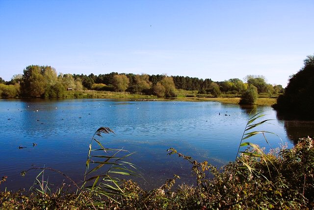 Lackford Lakes Nature Reserve
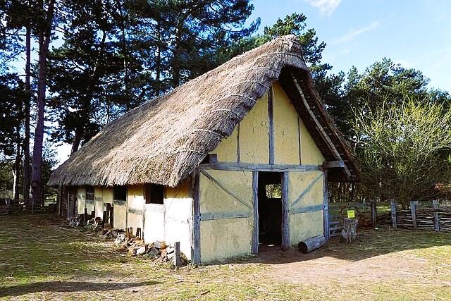 A hut in West Stow Anglo-Saxon Village
West Stow Country Park, where the walk begins covers 125 acres on the southern edge of Breckland. The park, and neighbouring Lackford Lakes Nature Reserve, offers a variety of habitats, including heath, plantation, woodland, river and lake, and claims over 300 plant species. Many of these, such as maiden pink, sand sedge and mossy tillaea, are Breckland specialties, well adapted to the region's low rainfall and sandy soil. Around 120 different species of birds have been seen - the Lackford Lakes are particularly important for wintering wildfowl, including the relatively rare gadwall, while the River Lark is a through route for many migrating birds. Toads, weasels, hares, muntjacs and roe deer are just some of the animals frequenting the park, but most are shy and seldom seen. At the heart of the country park is the Anglo Saxon village of West Stow.
From the country park, the first section of the walk goes through King's Forest, the southernmost part of Thetford Forest. Thetford, one of the very first forests established by the Forestry Commission, is now the country's largest lowland forest, and its premier pine forest. As well as conifers, there are belts of broadleaves, especially beech oak and sycamore. Clear felling started in the early 1970s - the first plantations were then some fifty years old, so the forest now presents a vast mosaic of distinct habitats - ranging from newly felled sites through to mature stands which shelter a wide variety of wildlife.
The bird population, for example, includes nightjars, woodlarks and tree pipits in clear felled areas and woodland species such as the goldcrest, siskin, crossbill, long-eared owl, sparrowhawk and goshawk among the pines.
Part of the route through King's Forest follows the Icknield Way path. The Icknield Way, which is probably the country's oldest road, curves across England from Norfolk to Wiltshire, following a natural line of chalk. In prehistoric times, the way was not a well defined track, but rather a broad swathe of downland, safe above low-lying marshes and free from dense forest. Over centuries routes along this ancient chalkland way frequently shifted, to accommodate changing conditions under foot.
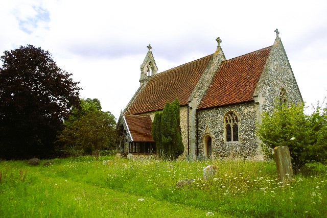 All Saints Church, Wordwell
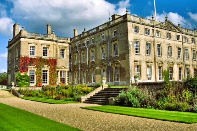 Culford School
Shortly after leaving the forest, the path comes to Wordwell, one of Breckland's lost villages. All that remains of the medieval settlement is the tiny church of All Saints, standing lonely against the sky. Built in the early 12th century, it was much restored in the 19th century, but retains some medieval features. Among the most interesting are the north and south doorways, both Norman, with remarkable carved stone tympana. Inside, the chancel arch and font are also Norman, while the wooden benches with beautiful poppyhead ends, and animal carvings, date from the 15th century. All Saints is now maintained by the Redundant Churches Fund.
From Wordwell, the path descends gently towards Culford. In doing so it passes a tree-topped tumulus, engagingly called 'the Hill of Health'. Culford is best known for its hall, now a school. Originally built in Tudor times by Sir Nicholas Bacon, step brother of the famous Francis, it was remodelled in the early 1800's for the first Marquess Cornwallis. Behind the hall, the church, rebuilt in 1856, has Bacon and Cornwallis memorials.
An attractive feature of the tree studded park, apart from its grazing flocks of sheep, is a long, narrow lake with a beautiful display of water lilies at its western end.
The way into West Stow village passes by the church of St Mary, flint-faced, like so many Breckland buildings. Although much restored in Victorian times, some original elements remain, including the tracery of the north windows, fragments of medieval class in the west window, and an 11th century door - the oldest part of the building.
West Stow itself is a neat village. Its cottages and gardens, arranged tidily behind sturdy flint walls. Standing well back from the village street, on the northern side, is a handsome red-brick gatehouse with octagonal corner turrets. Dating from the reign of King Henry VIII, the gatehouse is almost all that survives of the original Tudor Hall.
Acknowledgments: Text derived from the Out and Out Series; Discovering the Countryside on Foot. Pictures courtesy of Wikipedia.


