Heptonstall, Hebden Dale, Gibson Mill and Midgehole
Along old Pennine trade routes and through a fabulous wooded valley
Google Maps Open Source Maps| Statistics and Files | ||
|---|---|---|
| Start: Heptonstall | Distance: 4.4 miles (7.0 km) | Climbing: 252 metres |
| Grid Ref: SD 98689 28024 | Time: 2-3 hours | Rating: Easy |
| GPX Route File | Google Earth File | About Heptonstall |
| Statistics | |
|---|---|
| Start: Heptonstall | Distance: 4.4 miles (7.0 km) |
| Climbing: 252 metres | Grid Ref: SD 98689 28024 |
| Time: 2-3 hours | Rating: Easy |
| GPX Route File | Google Earth File |
Ordnance Survey Explorer Map (1:25,000)
The Walk: Heptonstall is a historic village with a steep and winding cobbled street. he earliest cottages date back to the 16th century. In the 17th and 18th centuries, when Heptonstall was at its peak as a textile community, some cottages were the homes of handloom weavers. These are distinguishable by their rows of upstairs windows, which allowed the weavers as much light as possible with which to work.
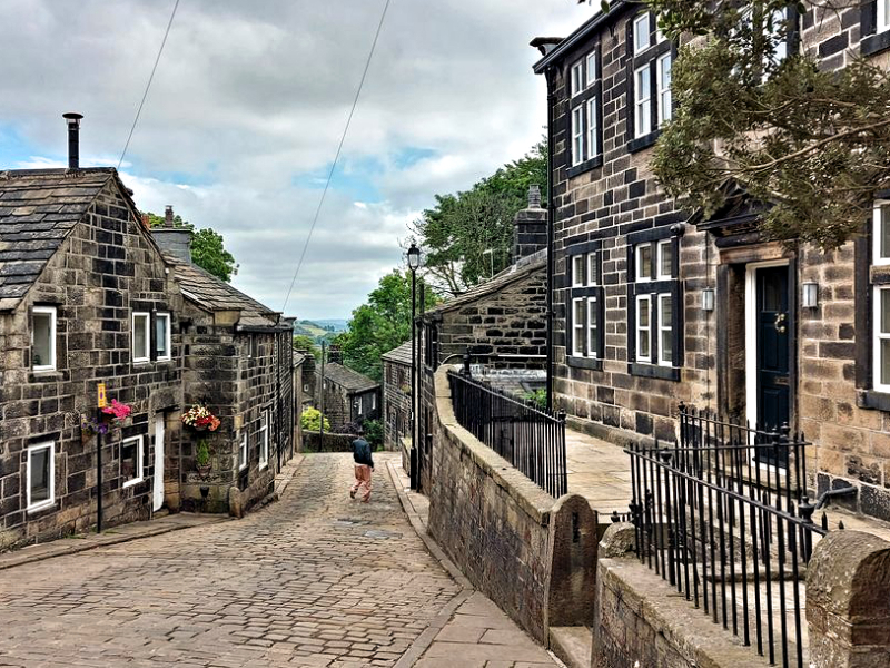 Heptonstall
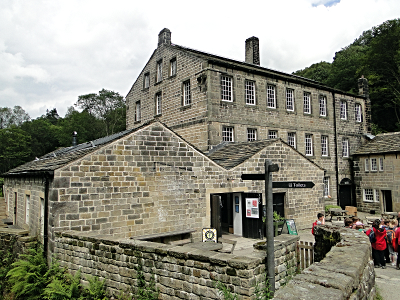 Gibson Mill
As you leave the village you pass the parish church. The graves in the churchyard include that of David Hartley, who was hanged in York in 1770 for counterfeiting gold coins. He was a member of the notorious Cragg Vale Coiners. Just beyond the church are the ruins of a 15th century chapel dedicated to St Thomas à Becket, and next to them stands the village's Old Grammar School of 1642.
Heptonstall lies on an old route between Halifax and Burnley. The walled lane that leads out to Heptonstall Crags, Eaves Lane, was once a route for packhorses and pedestrians. It passes through the South Field of a medieval two-field farming system. The North Field lies beyond the church. Farmers were allotted strips within the fields, which were used alternatively for growing corn, then left fallow. The terraced hummocks of the ridge and furrow strips are still visible in the lawns of the houses.
Heptonstall Crags are an outcrop of gritstone. From this vantage point, there are excellent views down the Calder valley. The stone tower visible across the valley is Stoodley Pike, erected to commemorate the Battle of Waterloo. (See my Stoodley Pike walk).
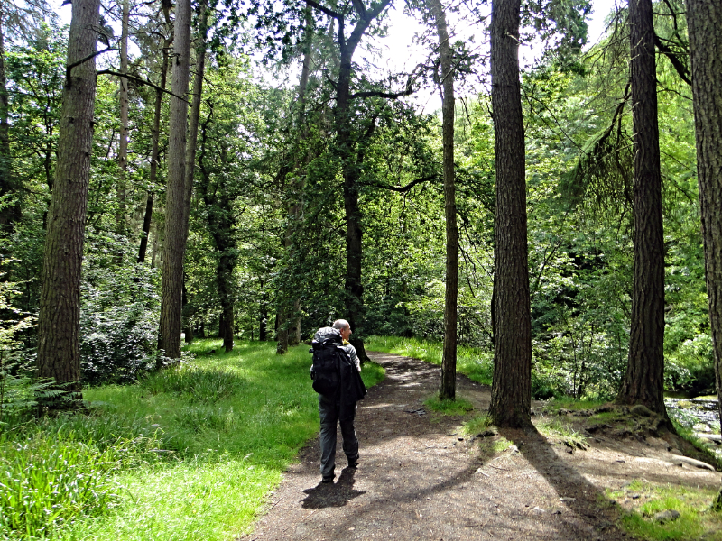 Hiking in Hebden Dale
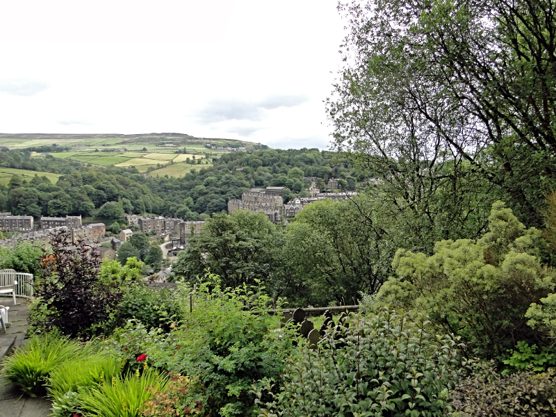 View from Midgehole to Hebden Bridge
Down below is Colden Water. The area around here used to be owned by the monks of Fountains Abbey, and they built a number of small water-mills in the valley. The mills were later converted to steam power, but much of the early water engineering remains, now hidden in dense woods.
Murking Lane, another walled and partly paved lane, is followed for a time from Heptonstall Crags. It now forms part of the Calderdale Way long distance footpath. There were many such routes between mills and villages, and, at the top of this lane, there is an intersection of five of these Pennine tracks.
The route goes through slack, where a 17th century finger-post indicates 'Burnly', an archaic spelling of Burnley. A green lane, lined with bilberry bushes, leads you to a wooded ravine, and you descend to Hebden Water. The woods of Hebden Dale are a botanist's paradise,with the flora including enchanter's nightshade, wood anemones, yellow pimpernel and pink campion. The treecreeper, a small bird with a curved beak, probes the bark of trees here for insects.
You cross Hebden Water by a footbridge beside the mill pond used to serve Gibson Mill. The deserted mill is named after Abraham Gibson, a cotton spinner. Next to the mill is a track with a stone bridge, originally a toll bridge. Gibson Mill now has shops including a cafe for refreshments which is very popular in the summer months. The route from Gibson Mill, following one of my walks, heads through lush woodland down Hebden Dale towards Midgehole. The woods here are home to wood ants, which make their nests out of the needles of Scots Pine which grows alongside broadleaved trees in the wood. In spring there is a carpet of bluebells to enjoy on the woodland floor, and you will also find wild hyacinth. At Midgehole, you cross Hebden Water by another old tollbridge, and head uphill along a track.
At the top of the track, there are excellent views over the town of Hebden Bridge. Steep lanes radiate at all angles, and the houses are built tall and narrow in order to make the best use of scarce valley bottom land. The colours of the stone houses and cottages reflect the hues of the surrounding hills. A further steep hill returns you to Heptonstall and the starting point of the walk.
Acknowledgments: Text derived from the Out and Out Series; Discovering the Countryside on Foot. Pictures courtesy of Wikipedia.


