Sandwich, Royal St George's, Stour Valley Walk and Richborough Castle
Three walks in one, centered around an historic Cinque Port
Google Maps Open Source Maps| Statistics and Files | ||
|---|---|---|
| Start: Sandwich | Distance: 8.3 miles (13.4 km) | Climbing: 16 metres |
| Grid Ref: TR 33326 58200 | Time: 4 hours | Rating: Easy |
| GPX Route File | Google Earth File | About Sandwich |
| Statistics | |
|---|---|
| Start: Sandwich | Distance: 8.3 miles (13.4 km) |
| Climbing: 16 metres | Grid Ref: TR 33326 58200 |
| Time: 4 hours | Rating: Easy |
| GPX Route File | Google Earth File |
Ordnance Survey Explorer Map (1:25,000)
The Walk:
In the Middle Ages, the town of Sandwich was one of England's most flourishing ports. One of the original Cinque Ports, it stood at the southern end of the River Wantsum, the navigable channel that seperated the Isle of Thanet from the mainland.
In the 15th century, the Wantsun silted up and Sandwich lost its sea harbour. The town's importance faded, but this has helped to preserve its fabric. Today, it is one of the most complete medieval towns in the country.
This walk has three distinct parts. The first takes you from Sandwich to the sea and back across a famous golf course; the second takes you out to see the remains of Richborough Castle, which guarded the entrance to the Wantsum; and the third explores the town itself.
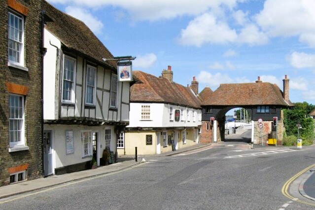 Old Tollgate in Sandwich
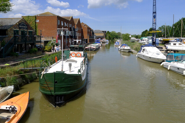 River Stour in Sandwich
The walk begins at The Quay. The Butts Stream and the Delph River thread their ways through the town, and the quays on the River Stour give an impression of how lively the medieval port once was.
In its 400 year retreat from Sandwich, the sea left salt marshes, sand dunes, and tidal mud flats in its wake. The walk heads across this new land which provides important wildlife habitats. Redshanks, shelduck, ringed plovers, and little terns breed here. Sanderlings, grey plovers, snow buntings and hen harriers can be found in the winter, and Sandwich Bay is a stopping off place for many migrants birds.
Clumps of pearly grey sea holly and pink roses grow on the dunes, along with sea sandwort, ragwort and the common mallow. Lady's bedstraw and wild asparagus border the paths and bulrushes, reeds, and the giant sharp rush grow in the water margins.
The dunes are also the location of the Royal St George's Golf Club, whose famous links course has been the venue for several Open Championships, is crossed by the walk. The famous Scottish golfer, Sandy Lyle, won his only British Open title here in 1985.
You return to the town by following the Stour Valley Walk to arrive around the massive ramparts of its 14th century walls, which line the town's landward side. They might have been designed for the 20th century tourist. From their heights you can see the closely grouped roofs of the town, dominated by the three remaining church towers.
The ramparts rise above the ditches to a height of 20 feet in places, forming an angle of 60 degrees. The best place for seeing the mighty chimneys of The Salutation, which was designed by Sir Edwin Lutyens in 1911, is from The Bulwarks, at the start of the wall top walk.
At the other end of the wall, between the tower and a road, is Gazen Salts Nature Reserve, one of three reserves in the area. You continue past it and head north towards Richborough.
This stretch of coast has for thousands of years been the landfall for invaders of all kinds; birds, butterflies, windborne seeds and armies. In AD43 Romans established a bridgehead at Richborough, which they called Rutupiae (Richborough Castle). Initially it was a supply base, but by the end of the century an enormous triumphal arch stood on a promontory facing the sea, making it eminently clear that Imperial Rome ruled here and was here to stay.
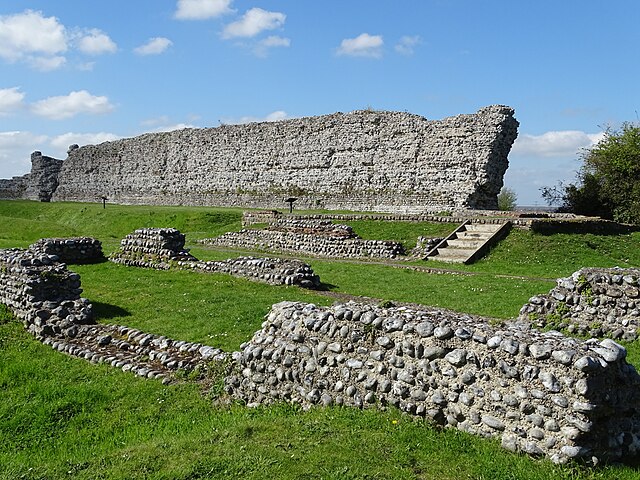 Richborough Castle Roman Fort
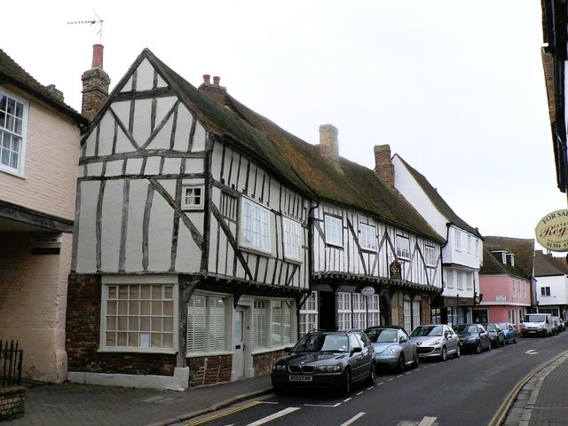 Strand Street, Sandwich
A settlement grew around the arch, but by the 2nd century barbarian invaders were making life in Britain less secure. The arch was demolished, leaving only the base, which can still be seen. A fort covering five acres was built. Its walls still stand to a height of 25 feet, striking testimony to the potential gravity of the Anglo-Saxon raids.
You return to Sandwich the way you came. To wander anywhere in the town is a delight and the route can only cover the principal sites. Strand Street, the old harbourside street, is full of timber framed houses, many distinguished by later brick fronts. Manwood Court, with its cross stepped gables, was built as a grammar school in 1580 in Sandwich. Brick made from the local river mud, this brick can be seen all over the town.
At the corner of Paradise Row, a decorated stone doorway in a wall is all that remains of a prosperous early 14th century house.
The jetted Long House is 16th century, with an 18th century false front that is best seen from the east end. The name of nearby Monk Quay recalls the presence of its owners in the Middle Ages, the monks of Christchurch, Canterbury.
At the junction with Church Street is The King's Arms, which has a corner bracket dated 1592, carved as a satyr. Opposite the pub is St Mary's Church, a sad relic of town decay. The central tower fell in 1668, irretrievably damaging the early 12th century interior. Now redundant, the barn like church has a desolate feel to it inside.
Beyond St Mary's is the Old House, once a hostel for pilgrims on their way to Canterbury. This, too, is a timber framed building, refaced in brick in 1713.
The Sandwich Doll Museum, of interest to all ages, faces you across the precinct, while in Harnet Street is a Georgian milestone, inscribed with the distances to Deal, Canterbury and London. Close by is a blocked 15th century wooden doorway with roses in the spandrels. In the fine course flint wall opposite can be seen the remains of a Gothic arch.
At the top of Harnet Street, you turn left to the Guildhall, whose showpiece is the 17th century courtroom with a collapsible jury box. The floor could be cleared to leave it free for the merchants of the various guilds to trade. In the council chamber above is the mayor's chair, which dates from 1561.
The old cattle market around Sandwich Guildhall has become a car park. Beyond it, narrow streets cluster round St Peters, another victim of the town's inability to repair its buildings. The central tower fell in 1661, removing the south aisle. The townsfolk could only afford to rebuild in Sandwich brick.
The present parish church, St Clements, still has its Norman crossing tower, with three tiers of arcading outside and another inside. The angel roof is more typical of East Anglia churches, and reflects the fact that sea travel to the east coast ports was easier than travel inland during the Middle Ages.
From St Clements you make for Fisher Street, a fine example of the variety of buildings in Sandwich. Jetties, Georgian and Victorian redbricks and walls washed green, pink, cream and grey, stand side by side.
From here, Quay Lane leads to Fisher Gate. Built in 1384, after the French first stacked the town, it is the only remaining town gate and is built in faced flints up to the string course. Above that it was restored by the Cooper's Guild in 1560 in Sandwich brick. It is interesting to compare the black brick diaper pattern as seen from Quay Lane with the pattern on the seaward side, where workmen got it wrong.
Acknowledgment: Text derived from the Out and Out Series; Discovering the Countryside on Foot. Pictures courtesy of Wikipedia.


