Chirk, River Ceiriog, Chirk Castle and Llangollen Canal
Through a canal tunnel and over an aqueduct via Chirk Castle
Google Maps Open Source Maps| Statistics and Files | ||
|---|---|---|
| Start: Chirk Station | Distance: 6.5 miles (10.4 km) | Climbing: 326 metres |
| Grid Ref: SJ 28453 37797 | Time: 3 hours | Rating: Moderate |
| GPX Route File | Google Earth File | The Ceiriog Valley |
| Statistics | |
|---|---|
| Start: Chirk Station | Distance: 6.5 miles (10.4 km) |
| Climbing: 326 metres | Grid Ref: SJ 28453 37797 |
| Time: 3 hours | Rating: Moderate |
| GPX Route File | Google Earth File |
Ordnance Survey Explorer Map (1:25,000)
The Walk: This walk, which begins in the Welsh town of Chirk (Y Waun) explores the Border country between Wales and England. It is fascinating from start to finish. A canal and the infrastructure to support it from the Industrial Revolution are prevalent from the start of the walk and when out in the countryside on the second half of the walk a striking medieval castle is visited. Apart from the evidence of man, the natural world is beautifully witnessed with flora and fauna abounding throughout. (Note: This walk can only be completed when the grounds of Chirk Castle are open. Pease check before undertaking the walk)
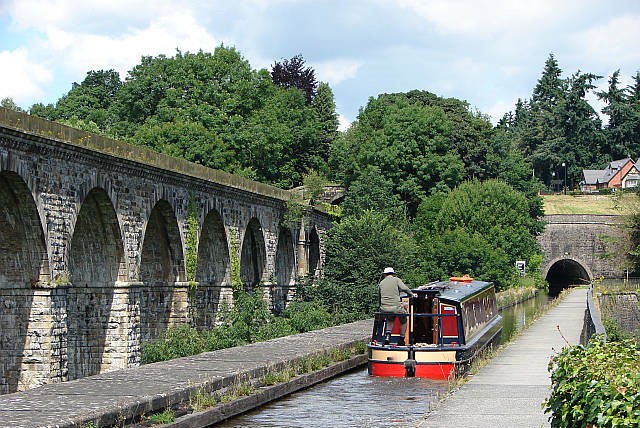 Chirk Aqueduct
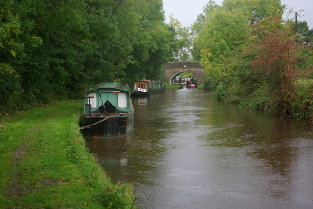 Llangollen Canal
Horse drawn trams once pulled trucks of slate around here, and the lines promoters spotted its potential as a tourist attraction. The tracks have gone, but it remains popular with walkers at its junction with Offa's Dyke Path and the Maelor Way. The Industrial Revolution led to the construction of transport routes to open up the mineral wealth of this area. One of these was the quaint little Glyn Valley Tramway (GVT). This used to go under the second of the two bridges at Chirk Station, where it terminated. The GVT followed the River Ceiriog for nine miles between Glyn Ceiriog and Chirk. The trucks were drawn by horses between 1873 and 1888. The eastern terminus was the canal at Chirk Bank but the introduction of steam haulage services in 1888 led to a new terminus at Chirk Station.
Slate, and later granite, was carried along a track running on the Welsh side of the River Ceiriog west of Pont-faen Bridge. In 1891 passenger trains were introduced but they finally succumbed to rival bus services in 1933, the line closing to all traffic just two years later in 1935. At its peak, however, it had four locomotives, 14 passenger coaches, 258 wagons and a staff of thirty-two.
The canal is a wildlife reserve. The section of the walk that follows the viaduct goes through the reserve where there are dragonflies, butterflies, water skaters and water boatmen. In the water are roach, perch, bream, rudd, pike, tench and carp with coot and moorhen above. The valley is rich in bird life, including wagtails, dippers, skylarks, meadow pipets, green woodpecker, hedge sparrows, blackbirds, thrushes, crows and magpies. There are blackberries, foxgloves, raspberry, willow herbs and yellow pimpernel. Primrose adorns the woodland in spring when there is the smell of wild garlic.
The dark tunnel is 459 yards long and shows the power of the owner of Chirk Castle, for it was built to preserve his view. Since 1963 the waterway has been called the Llangollen Canal, but was originally the Ellesmere Canal, planned in 1791 to link the River Severn with the rivers Dee and Mersey. It was never completed because of financial problems, but it did link with the Chester Canal in 1805. The canal passed into the hands of the London and North Western Railway, which ran it in competition with the trains of the Great Western Railway.
Thomas Telford and William Jessop built the aqueduct at Chirk. Its construction took from 1796 to 1801 and it stands 70 feet above the River Ceiriog. It is 696 feet long and 11 feet wide, within which is the iron trough containing the canal. There are 10 arches, each with a span of 40 feet. Overlooking the aqueduct is the Chirk Railway Viaduct. This fine example of Victorian architecture was built in 1848 for the Great Western Railway by Henry Robertson, who was notorious for surveying the land by night to avoid hostile landowners. It has 10 arches, each with a span of 45 feet. At 286 yards in length it stands 100 feet above the valley floor.
The aqueduct is a fine vantage point. Notice the church away to your left which is now dedicated to St Mary. Chirk may be a corruption of church or kirk, although the Welsh name is 'Y Waun', meaning The Moor. The village guarded the River Ceiriog so the Normans built a motte and bailey castle just below the church in the early 12th century. The remaining mound marks the site of the original 'Castell y Waun'.
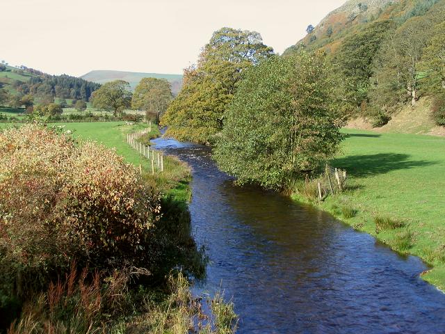 River Ceiriog
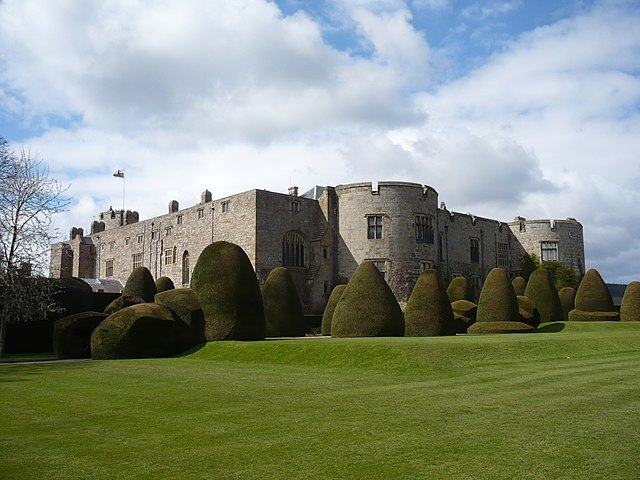 Chirk Castle
Following the Maelor Way, a 24 mile long route linking Offa's Dyke Path with the Cheshire Sandstone Trail, notice the remains of a dovecote. There are small square holes in the end wall of a barn dated 1778. Eventually you will reach Offa's Dyke Path at a well preserved part of the dyke. This was erected by King Offa of Mercia in the late 8th century. Near the dyke, towards the hamlet of Bronygarth, you may come across some limekilns. These processed lime from the quarries for use as a field dressing.
The gap in Offa's Dyke formed by the River Ceiriog is known as the 'Pass of the Graves'. The Battle of Crogen was fought here in 1165 when Henry II invaded Wales with an army of mercenaries, including some from Anjou in France. Henry and his allies were heavily defeated here by the valiant Welsh.
The 18th century landscaped park of Chirk Castle contains a lake that drowns part of Offa's Dyke. Chirk Castle was completed in 1310. It was built by the Marcher Lord Roger Mortimer to consolidate Edward I's conquest of Wales in 1282. Instead of providing the English crown with security in Wales though, it provided a long list of traitors. At least five of its owners had been executed for treason before the estate was sold to Thomas Myddleton in 1595. His descendants still here, though the castle was acquired by the National Trust in 1978.
The castle was badly damaged by Parliamentary artillery during the Civil War. Its 15 foot thick walls are aligned on the Cardinal points of the compass and its four corner towers are 47 feet in diameter. Its appearance has changed little with the courtyard enclosed by high sandstone walls and massive drum towers. It has been restored and converted into a stately home with elegant plaster work distinguishing the interior. The parkland has a Ha-Ha built in a ditch to keep in livestock without causing instruction to the view from the castle. As you leave the grounds, notice the timber frame cottage. Its end wall probably dates from the 15th century, while the timbers may have been recycled from galleons.
Acknowledgment: Text derived from the Out and Out Series; Discovering the Countryside on Foot. Pictures courtesy of Wikipedia.


