Aberdare, Dare Valley, Mynydd Bwllfa and Mynydd Cefn y gyngon
A walk through hills and valleys in a post-industrial landscape
Google Maps Open Source Maps| Statistics and Files | ||
|---|---|---|
| Start: Dare Visitor Centre | Distance: 7.6 miles (12.3 km) | Climbing: 400 metres |
| Grid Ref: SN 98439 02624 | Time: 3-4 hours | Rating: Moderate |
| GPX Route File | Google Earth File | About Aberdare |
| Statistics | |
|---|---|
| Start: Dare Visitor Centre | Distance: 7.6 miles (12.3 km) |
| Climbing: 400 metres | Grid Ref: SN 98439 02624 |
| Time: 3-4 hours | Rating: Moderate |
| GPX Route File | Google Earth File |
Ordnance Survey Explorer Map (1:25,000)
The Walk: When the Countryside Act of 1968 gave money to local authorities to make country parks, efforts were made to return the Dare Valley, long disfigured by spoil heaps and rusting railway lines, to its original condition. The tips that overshadowed Cwmdare village were spread out over the valley floor, and the colliery machinery was dismantled and removed. Trees were planted and the River Dare, contained in the culvert, was brought back above ground to create lakes and waterfalls.
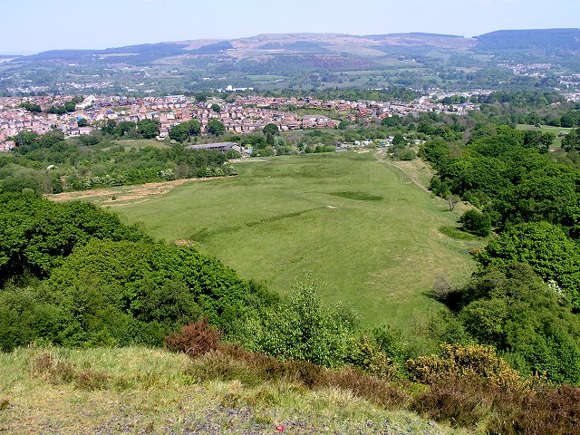 Dare Valley Country Park
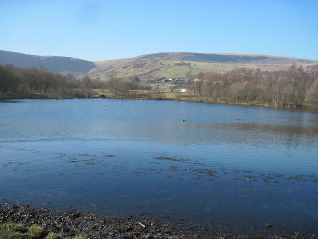 Lake in Dare Valley Country Park
Dare Valley Country Park Visitor Centre, where this walk begins, is built on the site of Powell's Pit. The stones for its walls, and the cast iron pillars inside, were taken from redundant chapels in the area.
The route follows a tarmac road and turns off where a man made waterfall cascades under a bridge into a pond. A sign indicates the route of the Coed Morgannwg Way, a long distance footpath that starts at Margam and continues for 36 miles (58 kilometres) to Gethin. Here, there was once a hamlet, Pithead, that served the Merthyr Dare Colliery. Nothing remains of either site now, other than a few grass covered spoil heaps up the hill on the left.
As you climb the slope into a small wood, the route follows a sunken track. The stones underfoot, and the drainage ditch to the side, indicates that this is an example of a man made parish road from before the coal mining era. This well preserved early route to Rhondda survived in its original state because other more convenient roads were built, leaving this one to the walker.
The ruined cottage on the left of the track at Pen-rhiw-Hech, abandoned in 1938, is a reminder of the system of farming whereby shepherds took their flocks to the high meadowland or 'hafod' in summer, and retreated to the shelter of the valleys in winter. There is additional evidence of this practise, in a number of ruined dwellings on the surrounding hillsides.
There are woodpeckers in the scant woodland of birch, oak and elder.; their holes can be seen in the tree trunks. On the steep slopes and open moorland, the mew of the buzzard is a common sound, and ravens live here too. Peregrine falcons regularly hunt over the area.
Are you climb higher, you can see two lakes visible in the valley below. One is a reservoir, the other is part of the parks leisure facilities. They mark the site of Bwllfa Colliery, one of the largest in the area. Nothing remains now except a row of cottages. To the left of Bwllfa Dare Terrace is Bwllfa House, which was originally a farm. When mining began, it became the property of the colliery manager. And in due course it was enlarged.
Ahead looms the steep cliffs of Tarren y Bwllfa. The hollowed out shape was created by a glacier which formed on the north facing slope. Bwllfa is one of the oldest place names in the district, and means 'basin' or 'site of a pool' suggesting that there may have been a glacial lake at the foot of the cliff.
The path emerges onto the flat land behind Tarren y Bwllfa and follows a narrow ridge of higher ground studded with granite outcrops. Beyond it, the land is boggy, and drains not into the Dare, as you would expect, but into the Rhondda Fach Valley to the south-west. On the left, in the distance, is the grass covered dam of Lluestwen Reservoir, with the darker green of conifer plantations beyond.
A quick detour takes you to the Berw-ddu waterfall, where the Dare drops over Tarren y Bwllfa. Berw-ddu means 'dark foaming' but it is only spectacular in very wet weather. Normally the moss absorbs the small amount of water.
The wet peaty soil supports marsh thistle, star sedge and creeping buttercup, while grasshoppers and frogs are found among the clumps of purple moor-grass.
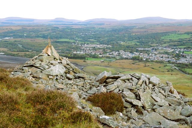 Summit view from Mynydd Cefn y gyngon
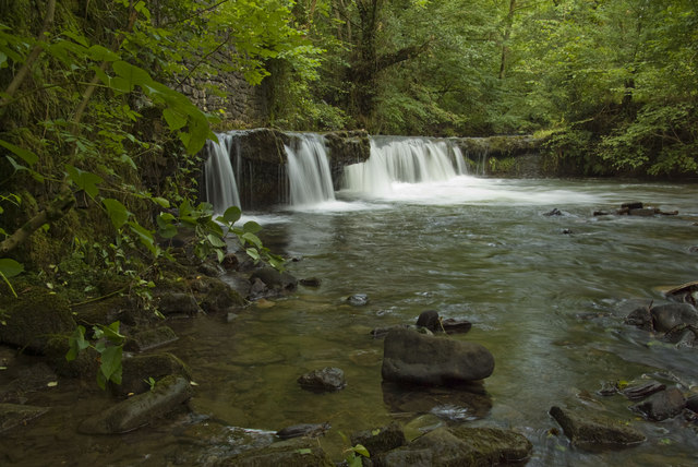 Gadlys Falls, River Dare
The route heads north, and passes a trig point, marking the summit of these hills at 1,672 feet (510 metres). At the cliff top of Tarren y Bwlch, the view is superb. On the clear day, the distinctive outline of the Brecon Beacons can be seen on the horizon. In the foreground is the town of Hirwaun. And immediately below is the site of Tower colliery, the last operative mine in the South Wales coalfield.
Just beneath the cliffs is evidence of a prehistoric settlement. As you go downhill on the broad track, you pass pre-Roman rock cairns. The sheep pen in the middle of these is 18th century in origin, but archaeologists have identified a prehistoric settlement nearby, of 17 round huts and enclosures.
The winding path takes you to the edge of Cwmdare village. It passes to the right of a mound of grass-covered stones with a concrete plug at their centre. This is a disused airshaft, one of many that served the underground tunnels in the area.
The route crosses the country park almost to the start of the walk, but turns left to join a tarmac path lined with oak, elder and birch trees, that heads along the river towards Aberdare. The riverside was once a source of fascination to local people. At one spot, flammable gas seeped up through the water, making it possible to 'set the river on fire'.
Soon, you come to some brick pillars overgrown with ivy and ferns. These are all that remain of a wooden viaduct built by Isambard Kingdom Brunel, to take another line across the river. It was 450 feet (137 metres) long and 70 feet (21 metres high); and a scale model of it can be seen in the visitor centre. The viaduct was dismantled in 1947, with just its supports left standing. Brunel was responsible for the Dare Aman Railway, which you follow on the return route. The path passes under a bridge and a pipe, the remnants of their junction station, which was situated here.
The line of which the viaduct was a part was in competition with the Taff Vale line, although there is evidence that it carried timber and supplies, rather than coal. It was initially constructed in broad gauge so that it could link up with the South Wales Railway, but had to be reduced to standard gauge when it became part of the Great Western Railway. Between 19O6 and 1924, the Dare Aman line carried passengers. It was closed to all traffic in 1939.
The return route passes a sign to Llwyn-helyg Farm. According to tradition, a plant grew in the fields here that made cattle vicious if they ate it. It must have had some effect on humans too, for in 1868 Thomas Morris from Aberaman stole some gunpowder from a local pit and attempted to blow up the farm. Although the house was damaged, no one was injured. Later, the land was mined, and the old spoil heaps of Llwyn-helyg Colliery can be seen beside the road.
Acknowledgment: Text derived from the Out and Out Series; Discovering the Countryside on Foot. Pictures courtesy of Wikipedia.


